Property Record
N 500 W, Mccordsville, IN 46055
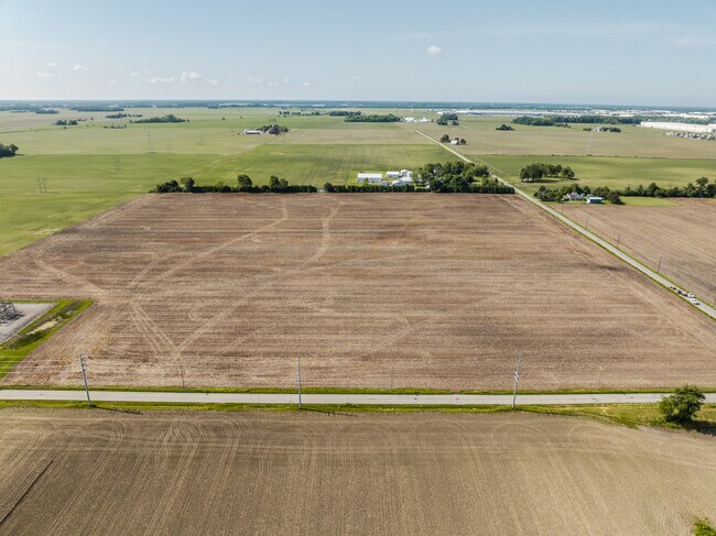

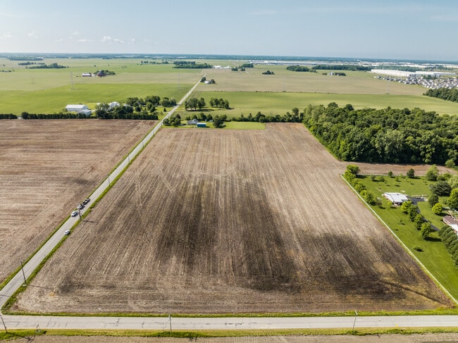
This Property Is For Sale
NEARBY LISTINGS FOR SALE OR LEASE
Property Detail
N 500 W
30-02-31-200-001.000-016
N NW 31-17-6 61.916AC
Agriculturalland
Hancock
X
Indiana
18057C0275G
61.92 AC
2024
Hancock County
2024
Indianapolis
410201
Indianapolis-Carmel-Anderson, IN
DEMOGRAPHICS near N 500 W
1 Mile
3 Mile
5 Mile
2024 Total Population
297
17,139
63,834
2029 Population
341
18,712
67,815
Pop Growth 2024-2029
+ 14.81%
+ 9.18%
+ 6.24%
Average Age
35
37
38
2024 Total Households
106
6,067
22,584
HH Growth 2024-2029
+ 15.09%
+ 9.25%
+ 5.84%
Median Household Inc
$85,185
$93,770
$109,249
Avg Household Size
2.80
2.80
2.80
2024 Avg HH Vehicles
2.00
2.00
2.00
Median Home Value
$256,382
$248,337
$283,806
Median Year Built
2010
2004
1999
Nearby Places
Map Layers
Map Styles
 Street
 Aerial
- Restaurants
- Banks
- Shops
- Fitness
- Groceries
PUBLIC TRANSPORTATION
AIRPORT
Indianapolis International
DRIVE
WALK
Distance
Indianapolis International
57 min
34.1 mi
Freight Ports
Port of Toledo
DRIVE
WALK
Distance
Port of Toledo
253 min
208.5 mi
Nearby Properties
Address
Land Use
TOTAL SIZE
Lot Size
Zoning
Address
Land Use
TOTAL SIZE
Lot Size
Zoning
2,896,370 SF
54.48 AC
Address
Land Use
TOTAL SIZE
Lot Size
Zoning
77.34 AC
Address
Land Use
TOTAL SIZE
Lot Size
Zoning
13.89 AC
Address
Land Use
TOTAL SIZE
Lot Size
Zoning
61.08 AC
Address
Land Use
TOTAL SIZE
Lot Size
Zoning
2,398 SF
64.58 AC
Address
Land Use
TOTAL SIZE
Lot Size
Zoning
390,106 SF
25.24 AC
Address
Land Use
TOTAL SIZE
Lot Size
Zoning
28.71 AC
Address
Land Use
TOTAL SIZE
Lot Size
Zoning
94,472 SF
15.91 AC
Address
Land Use
TOTAL SIZE
Lot Size
Zoning
259,780 SF
20.36 AC
Address
Land Use
TOTAL SIZE
Lot Size
Zoning
43,530 SF
5.06 AC
Address
Land Use
TOTAL SIZE
Lot Size
Zoning
16,836 SF
16.90 AC
Address
Land Use
TOTAL SIZE
Lot Size
Zoning
28,144 SF
10.70 AC
Address
Land Use
TOTAL SIZE
Lot Size
Zoning
192,246 SF
27.51 AC
Address
Land Use
TOTAL SIZE
Lot Size
Zoning
97.07 AC
Address
Land Use
TOTAL SIZE
Lot Size
Zoning
38,251 SF
10.45 AC
Address
Land Use
TOTAL SIZE
Lot Size
Zoning
28,494 SF
50.93 AC
Address
Land Use
TOTAL SIZE
Lot Size
Zoning
134,063 SF
14.43 AC
Address
Land Use
TOTAL SIZE
Lot Size
Zoning
114,675 SF
17.65 AC
Address
Land Use
TOTAL SIZE
Lot Size
Zoning
7,204 SF
2.85 AC
Address
Land Use
TOTAL SIZE
Lot Size
Zoning
17,269 SF
2.20 AC
Address
Land Use
TOTAL SIZE
Lot Size
Zoning
39,140 SF
4.05 AC
Address
Land Use
TOTAL SIZE
Lot Size
Zoning
40,147 SF
42.70 AC
Address
Land Use
TOTAL SIZE
Lot Size
Zoning
26,328 SF
2.96 AC
Address
Land Use
TOTAL SIZE
Lot Size
Zoning
38.09 AC
Address
Land Use
TOTAL SIZE
Lot Size
Zoning
22,535 SF
3.44 AC
Address
Land Use
TOTAL SIZE
Lot Size
Zoning
4,664 SF
6.69 AC
Address
Land Use
TOTAL SIZE
Lot Size
Zoning
12,881 SF
1.81 AC
Address
Land Use
TOTAL SIZE
Lot Size
Zoning
16,751 SF
1.68 AC
Address
Land Use
TOTAL SIZE
Lot Size
Zoning
37,826 SF
15.08 AC
Address
Land Use
TOTAL SIZE
Lot Size
Zoning
14,448 SF
10 AC
The World's #1 Commercial Real Estate Marketplace
Connect with us
© 2026 CoStar Group
The information above has been obtained from sources believed reliable. While we do not doubt its accuracy we have not verified it and make no guarantee, warranty or representation about it. It is your responsibility to independently confirm its accuracy and completeness. Any projections, opinions, assumptions, or estimates used are for example only and do not represent the current or future performance of the property. The value of this transaction to you depends on tax and other factors which should be evaluated by your tax, financial, and legal advisors. You and your advisors should conduct a careful, independent investigation of the property to determine to your satisfaction the suitability of the property for your needs.