Property Record
5000 Burrough Rd, Fort Smith, AR 72916


Save to a Folder
{{folder.Name}}
{{folder.ListingIds.length}} Properties
{{folder.ListingIds.length}} Property
Create a New Folder
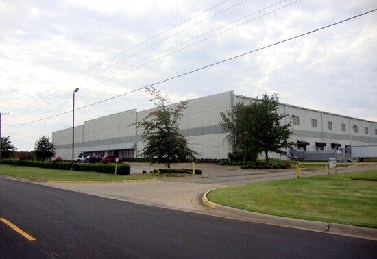
Property Detail
5000 Burrough Rd
Fort Smith, AR-OK
LT 2 TR 2
14017-0002-00000-02
Sebastian
Warehouse
Arkansas
B and X Area of moderate flood hazard, usually the area between the limits of the 100-year and 500-year floods.
2
2025
7.93 AC
2025
Greater Ft Smith
001306
Fort Smith
90,000 SF
NEARBY LISTINGS FOR SALE OR LEASE
DEMOGRAPHICS near 5000 Burrough Rd
1 mile
3 mile
5 mile
2025 Total Population
1,146
21,285
53,739
2030 Population
1,151
21,457
54,325
Pop Growth 2025-2030
+ 0.44%
+ 0.81%
+ 1.09%
Average Age
44
40
41
2025 Total Households
469
8,987
22,846
HH Growth 2025-2030
+ 0.43%
+ 0.91%
+ 1.12%
Median Household Inc
$92,835
$89,317
$70,271
Avg Household Size
2.30
2.30
2.30
2025 Avg HH Vehicles
2.00
2.00
2.00
Median Home Value
$236,410
$245,706
$225,733
Median Year Built
1985
1991
1983
Nearby Places
Map Layers
Map Styles
 Street
 Aerial
Layers
 Traffic
 Biking
Places
Listings with unknown addresses are not visible on the map
- Restaurants
- Banks
- Shops
- Fitness
- Groceries
PUBLIC TRANSPORTATION
AIRPORT
Fort Smith Regional
Drive
Walk
Distance
Fort Smith Regional
14 min
6.4 mi
Freight Ports
Tulsa Port of Inola
Drive
Walk
Distance
Tulsa Port of Inola
141 min
112.1 mi
SALE & LEASE HISTORY
LISTING DATE
SALE/LEASE

Apr 17, 2017
For Lease
Apr 11, 2017
For Sale
Nearby Properties
Address
Land Use
TOTAL SIZE
Lot Size
Zoning
Address
Land Use
TOTAL SIZE
Lot Size
Zoning
124,455 SF
38.09 AC
Address
Land Use
TOTAL SIZE
Lot Size
Zoning
364,749 SF
32.41 AC
Address
Land Use
TOTAL SIZE
Lot Size
Zoning
212,590 SF
30.06 AC
Address
Land Use
TOTAL SIZE
Lot Size
Zoning
208,886 SF
212.42 AC
Address
Land Use
TOTAL SIZE
Lot Size
Zoning
342,092 SF
12.15 AC
Address
Land Use
TOTAL SIZE
Lot Size
Zoning
847,154 SF
66.34 AC
Address
Land Use
TOTAL SIZE
Lot Size
Zoning
21,556 SF
47 AC
Address
Land Use
TOTAL SIZE
Lot Size
Zoning
205,000 SF
30 AC
Address
Land Use
TOTAL SIZE
Lot Size
Zoning
1,174,056 SF
90.54 AC
Address
Land Use
TOTAL SIZE
Lot Size
Zoning
3,675 SF
21.98 AC
Address
Land Use
TOTAL SIZE
Lot Size
Zoning
13,911 SF
25.40 AC
Address
Land Use
TOTAL SIZE
Lot Size
Zoning
356,451 SF
44.13 AC
Address
Land Use
TOTAL SIZE
Lot Size
Zoning
242,000 SF
10.62 AC
Address
Land Use
TOTAL SIZE
Lot Size
Zoning
340,729 SF
26.25 AC
Address
Land Use
TOTAL SIZE
Lot Size
Zoning
89,157 SF
15.84 AC
Address
Land Use
TOTAL SIZE
Lot Size
Zoning
613,600 SF
54.46 AC
Address
Land Use
TOTAL SIZE
Lot Size
Zoning
419,250 SF
22.86 AC
Address
Land Use
TOTAL SIZE
Lot Size
Zoning
418,608 SF
27.04 AC
Address
Land Use
TOTAL SIZE
Lot Size
Zoning
108,519 SF
13.38 AC
Address
Land Use
TOTAL SIZE
Lot Size
Zoning
18,492 SF
2.03 AC
Address
Land Use
TOTAL SIZE
Lot Size
Zoning
29,522 SF
25 AC
Address
Land Use
TOTAL SIZE
Lot Size
Zoning
105.25 AC
Address
Land Use
TOTAL SIZE
Lot Size
Zoning
106,455 SF
5 AC
Address
Land Use
TOTAL SIZE
Lot Size
Zoning
61,881 SF
8.89 AC
Address
Land Use
TOTAL SIZE
Lot Size
Zoning
74,434 SF
8.63 AC
Address
Land Use
TOTAL SIZE
Lot Size
Zoning
108,000 SF
16.12 AC
Address
Land Use
TOTAL SIZE
Lot Size
Zoning
147,360 SF
20.71 AC
Address
Land Use
TOTAL SIZE
Lot Size
Zoning
168,195 SF
33.51 AC
Address
Land Use
TOTAL SIZE
Lot Size
Zoning
87,003 SF
5.29 AC
Address
Land Use
TOTAL SIZE
Lot Size
Zoning
111,684 SF
19.56 AC
The World's #1 Commercial Real Estate Marketplace
Connect with us
© 2026 CoStar Group
The information above has been obtained from sources believed reliable. While we do not doubt its accuracy we have not verified it and make no guarantee, warranty or representation about it. It is your responsibility to independently confirm its accuracy and completeness. Any projections, opinions, assumptions, or estimates used are for example only and do not represent the current or future performance of the property. The value of this transaction to you depends on tax and other factors which should be evaluated by your tax, financial, and legal advisors. You and your advisors should conduct a careful, independent investigation of the property to determine to your satisfaction the suitability of the property for your needs.