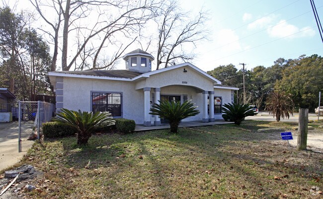
Property Record
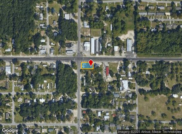
5000 E Highway 22, Panama City, FL 32404

NEARBY LISTINGS FOR SALE OR LEASE
Property Detail
5000 E Highway 22
Panama City-Panama City Beach, FL
St And Bay Dev Co Plat
24476-000-000
12 4S 14W -147- ST AND BAY DEV CO PLAT BEG AT NW COR LOT 68 TH E 155 S 100 W 155 N 100 TO BEG ORB 3556 P 2226
Officebuilding
Bay
X
Florida
12005C0363J
68
2024
0.36 AC
2025
Panama City
000803
Other Market Areas
2,000 SF
DEMOGRAPHICS near 5000 E Highway 22
1 mile
3 mile
5 mile
2024 Total Population
6,713
34,500
54,437
2029 Population
7,250
37,014
58,821
Pop Growth 2024-2029
+ 8.00%
+ 7.29%
+ 8.05%
Average Age
38
39
39
2024 Total Households
2,457
13,027
20,588
HH Growth 2024-2029
+ 8.55%
+ 7.81%
+ 8.49%
Median Household Inc
$47,293
$51,701
$53,082
Avg Household Size
2.60
2.60
2.50
2024 Avg HH Vehicles
2.00
2.00
2.00
Median Home Value
$137,713
$160,357
$174,486
Median Year Built
1979
1983
1985
Nearby Places
Map Layers
Map Styles
 Street
 Aerial
Transit
 Traffic
 Biking
Places
Listings with unknown addresses are not visible on the map
- Restaurants
- Banks
- Shops
- Fitness
- Groceries
PUBLIC TRANSPORTATION
AIRPORT
Northwest Florida Beaches International
Drive
Walk
Distance
Northwest Florida Beaches International
41 min
26.6 mi
Freight Ports
Port of Panama City
Drive
Walk
Distance
Port of Panama City
18 min
9.8 mi
SALE & LEASE HISTORY
LISTING DATE
SALE/LEASE

Mar 16, 2023
For Sale
Nearby Properties
Address
Land Use
TOTAL SIZE
Lot Size
Zoning
Address
Land Use
TOTAL SIZE
Lot Size
Zoning
764,032 SF
12.80 AC
PC14
Address
Land Use
TOTAL SIZE
Lot Size
Zoning
263,872 SF
41.33 AC
PC12
Address
Land Use
TOTAL SIZE
Lot Size
Zoning
226,068 SF
12.80 AC
Address
Land Use
TOTAL SIZE
Lot Size
Zoning
415,651 SF
266 AC
BC13
Address
Land Use
TOTAL SIZE
Lot Size
Zoning
55,300 SF
10.91 AC
PC12
Address
Land Use
TOTAL SIZE
Lot Size
Zoning
424,813 SF
30 AC
Address
Land Use
TOTAL SIZE
Lot Size
Zoning
143,208 SF
5.26 AC
Address
Land Use
TOTAL SIZE
Lot Size
Zoning
126,234 SF
20.02 AC
PI
Address
Land Use
TOTAL SIZE
Lot Size
Zoning
60,670 SF
15 AC
Address
Land Use
TOTAL SIZE
Lot Size
Zoning
189,909 SF
27.77 AC
PC14
Address
Land Use
TOTAL SIZE
Lot Size
Zoning
34,664 SF
19.20 AC
PC09
Address
Land Use
TOTAL SIZE
Lot Size
Zoning
181,571 SF
22.29 AC
CLWY04
Address
Land Use
TOTAL SIZE
Lot Size
Zoning
107,778 SF
10 AC
Address
Land Use
TOTAL SIZE
Lot Size
Zoning
126,164 SF
9.81 AC
R5
Address
Land Use
TOTAL SIZE
Lot Size
Zoning
43,110 SF
2.54 AC
PC09
Address
Land Use
TOTAL SIZE
Lot Size
Zoning
74,914 SF
14.23 AC
BC02
Address
Land Use
TOTAL SIZE
Lot Size
Zoning
39,628 SF
4.45 AC
CLWY04
Address
Land Use
TOTAL SIZE
Lot Size
Zoning
40,264 SF
2 AC
CLWY04
Address
Land Use
TOTAL SIZE
Lot Size
Zoning
43,564 SF
9.33 AC
C2
Address
Land Use
TOTAL SIZE
Lot Size
Zoning
42,456 SF
3.90 AC
CLWY04
Address
Land Use
TOTAL SIZE
Lot Size
Zoning
45,403 SF
2.65 AC
CLWY04
Address
Land Use
TOTAL SIZE
Lot Size
Zoning
48,576 SF
5.20 AC
CLWY23
Address
Land Use
TOTAL SIZE
Lot Size
Zoning
68,401 SF
30 AC
Address
Land Use
TOTAL SIZE
Lot Size
Zoning
74,996 SF
10 AC
PI
Address
Land Use
TOTAL SIZE
Lot Size
Zoning
39,298 SF
15.40 AC
PI
Address
Land Use
TOTAL SIZE
Lot Size
Zoning
56,716 SF
4.32 AC
Address
Land Use
TOTAL SIZE
Lot Size
Zoning
39,456 SF
8.70 AC
Address
Land Use
TOTAL SIZE
Lot Size
Zoning
67,478 SF
12.40 AC
PC14
Address
Land Use
TOTAL SIZE
Lot Size
Zoning
46,368 SF
2.30 AC
CLWY23
Address
Land Use
TOTAL SIZE
Lot Size
Zoning
103,006 SF
11 AC
The World's #1 Commercial Real Estate Marketplace
Connect with us
© 2026 CoStar Group
The information above has been obtained from sources believed reliable. While we do not doubt its accuracy we have not verified it and make no guarantee, warranty or representation about it. It is your responsibility to independently confirm its accuracy and completeness. Any projections, opinions, assumptions, or estimates used are for example only and do not represent the current or future performance of the property. The value of this transaction to you depends on tax and other factors which should be evaluated by your tax, financial, and legal advisors. You and your advisors should conduct a careful, independent investigation of the property to determine to your satisfaction the suitability of the property for your needs.