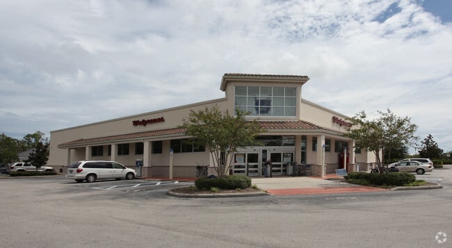
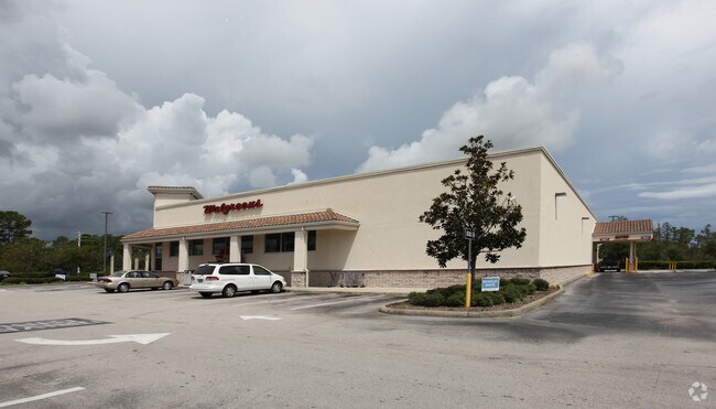
Property Record
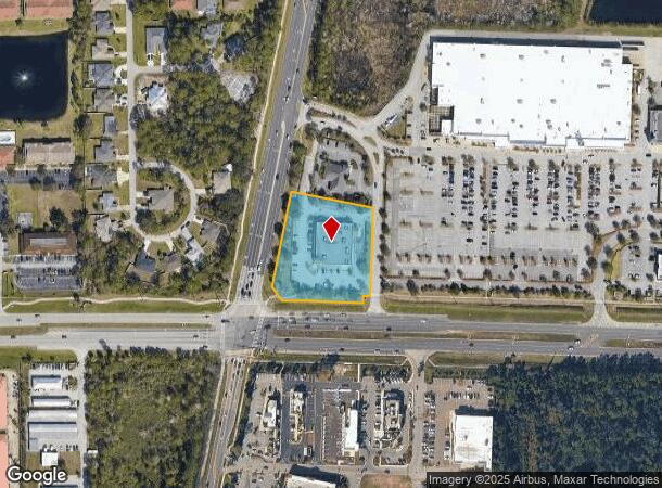
5000 E State Highway 100 E, Palm Coast, FL 32164
NEARBY LISTINGS FOR SALE OR LEASE
Property Detail
5000 E State Highway 100 E
Deltona-Daytona Beach-Ormond Beach, FL
Belle Terre
07-12-31-0650-000A0-0014
2.08 AC LYING ON THE NE CRNR OF SR 100 & BELLE TERRE, BEING 345 ON BELLE TERRE & 313.89 ON N R/W SR 100 (EXC 0.018 AC DOT #101.1) OR 594/648 OR 1139/566 OR 1139/570 OR 1168/1557-BLA OR 1401 PG 228
Storebuilding
Flagler
X
Florida
12035C0226E
14
2024
2.09 AC
2025
Flagler County
060213
Other Market Areas
14,850 SF
DEMOGRAPHICS near 5000 E State Highway 100 E
1 mile
3 mile
5 mile
2024 Total Population
2,771
30,598
61,348
2029 Population
3,413
37,494
75,103
Pop Growth 2024-2029
+ 23.17%
+ 22.54%
+ 22.42%
Average Age
49
45
45
2024 Total Households
1,169
12,149
24,249
HH Growth 2024-2029
+ 22.67%
+ 21.86%
+ 21.67%
Median Household Inc
$59,832
$57,753
$63,361
Avg Household Size
2.40
2.50
2.50
2024 Avg HH Vehicles
2.00
2.00
2.00
Median Home Value
$306,213
$255,987
$258,694
Median Year Built
2006
2004
2003
Nearby Places
Map Layers
Map Styles
 Street
 Aerial
Transit
 Traffic
 Biking
Places
Listings with unknown addresses are not visible on the map
- Restaurants
- Banks
- Shops
- Fitness
- Groceries
PUBLIC TRANSPORTATION
AIRPORT
Daytona Beach International
Drive
Walk
Distance
Daytona Beach International
36 min
26.8 mi
Nearby Properties
Address
Land Use
TOTAL SIZE
Lot Size
Zoning
Address
Land Use
TOTAL SIZE
Lot Size
Zoning
345,915 SF
94.85 AC
COM-2
Address
Land Use
TOTAL SIZE
Lot Size
Zoning
913,614 SF
85.53 AC
PSP
Address
Land Use
TOTAL SIZE
Lot Size
Zoning
320,259 SF
83.19 AC
P
Address
Land Use
TOTAL SIZE
Lot Size
Zoning
217,927 SF
1,165.37 AC
I-C
Address
Land Use
TOTAL SIZE
Lot Size
Zoning
280,742 SF
16.06 AC
MPD
Address
Land Use
TOTAL SIZE
Lot Size
Zoning
225,108 SF
41.71 AC
MPD
Address
Land Use
TOTAL SIZE
Lot Size
Zoning
236,316 SF
61.38 AC
PSP
Address
Land Use
TOTAL SIZE
Lot Size
Zoning
138,991 SF
18.66 AC
P
Address
Land Use
TOTAL SIZE
Lot Size
Zoning
141,171 SF
8.18 AC
MPD
Address
Land Use
TOTAL SIZE
Lot Size
Zoning
121,173 SF
10 AC
AC
Address
Land Use
TOTAL SIZE
Lot Size
Zoning
64,208 SF
8.41 AC
PSP
Address
Land Use
TOTAL SIZE
Lot Size
Zoning
69,026 SF
1.59 AC
MPD
Address
Land Use
TOTAL SIZE
Lot Size
Zoning
76,544 SF
48.85 AC
R/C
Address
Land Use
TOTAL SIZE
Lot Size
Zoning
124,911 SF
10.18 AC
PUD
Address
Land Use
TOTAL SIZE
Lot Size
Zoning
15.91 AC
PSP
Address
Land Use
TOTAL SIZE
Lot Size
Zoning
220,314 SF
17.41 AC
MPD
Address
Land Use
TOTAL SIZE
Lot Size
Zoning
82,459 SF
4.09 AC
MPD
Address
Land Use
TOTAL SIZE
Lot Size
Zoning
122,353 SF
17.97 AC
MPD
Address
Land Use
TOTAL SIZE
Lot Size
Zoning
208,450 SF
11.85 AC
MPD
Address
Land Use
TOTAL SIZE
Lot Size
Zoning
137,827 SF
7.66 AC
MPD
Address
Land Use
TOTAL SIZE
Lot Size
Zoning
68,684 SF
9.68 AC
MPD
Address
Land Use
TOTAL SIZE
Lot Size
Zoning
89,590 SF
9.90 AC
B-1
Address
Land Use
TOTAL SIZE
Lot Size
Zoning
220.05 AC
MPD
Address
Land Use
TOTAL SIZE
Lot Size
Zoning
42,025 SF
15.64 AC
MPD
Address
Land Use
TOTAL SIZE
Lot Size
Zoning
84,899 SF
10.35 AC
COM-2
Address
Land Use
TOTAL SIZE
Lot Size
Zoning
35,243 SF
8.45 AC
COM-3
Address
Land Use
TOTAL SIZE
Lot Size
Zoning
59,889 SF
0.75 AC
R-3A
Address
Land Use
TOTAL SIZE
Lot Size
Zoning
28,591 SF
3.84 AC
PUD
Address
Land Use
TOTAL SIZE
Lot Size
Zoning
54,500 SF
4.95 AC
COM-2
The World's #1 Commercial Real Estate Marketplace
Connect with us
© 2026 CoStar Group
The information above has been obtained from sources believed reliable. While we do not doubt its accuracy we have not verified it and make no guarantee, warranty or representation about it. It is your responsibility to independently confirm its accuracy and completeness. Any projections, opinions, assumptions, or estimates used are for example only and do not represent the current or future performance of the property. The value of this transaction to you depends on tax and other factors which should be evaluated by your tax, financial, and legal advisors. You and your advisors should conduct a careful, independent investigation of the property to determine to your satisfaction the suitability of the property for your needs.