Property Record
5000 Highway 22, Mandeville, LA 70471
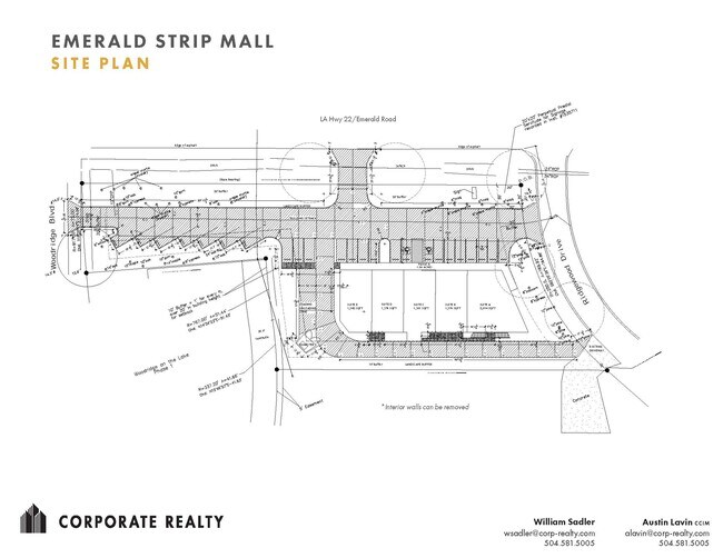

Property Detail
5000 Highway 22
Slidell-Mandeville-Covington, LA
PARCEL A CONT 1.059 ACS M/L SEC 54 7 11 INST NO 1343598 INST NO 1535707 INST NO 1977042
54192
Saint Tammany
Commercialnec
Louisiana
2025
1.06 AC
2025
Mandeville/Covington
040307
New Orleans/Metairie/Kenner
2,400 SF
NEARBY LISTINGS FOR SALE OR LEASE
DEMOGRAPHICS near 5000 Highway 22
1 mile
3 mile
5 mile
2025 Total Population
7,538
31,922
73,381
2030 Population
7,692
32,831
75,543
Pop Growth 2025-2030
+ 2.04%
+ 2.85%
+ 2.95%
Average Age
43
43
42
2025 Total Households
2,946
12,603
29,079
HH Growth 2025-2030
+ 2.00%
+ 2.94%
+ 3.01%
Median Household Inc
$94,874
$98,020
$89,260
Avg Household Size
2.50
2.50
2.50
2025 Avg HH Vehicles
2.00
2.00
2.00
Median Home Value
$421,392
$440,562
$387,550
Median Year Built
1989
1994
1996
Nearby Places
Map Layers
Map Styles
 Street
 Aerial
Layers
 Traffic
 Biking
Places
Listings with unknown addresses are not visible on the map
- Restaurants
- Banks
- Shops
- Fitness
- Groceries
PUBLIC TRANSPORTATION
AIRPORT
Louis Armstrong New Orleans International
Drive
Walk
Distance
Louis Armstrong New Orleans International
51 min
37.1 mi
Freight Ports
Port of New Orleans
Drive
Walk
Distance
Port of New Orleans
55 min
38.1 mi
SALE & LEASE HISTORY
LISTING DATE
SALE/LEASE

May 03, 2022
For Lease
Nearby Properties
Address
Land Use
TOTAL SIZE
Lot Size
Zoning
Address
Land Use
TOTAL SIZE
Lot Size
Zoning
Address
Land Use
TOTAL SIZE
Lot Size
Zoning
178,608 SF
34.02 AC
Address
Land Use
TOTAL SIZE
Lot Size
Zoning
277,159 SF
55.34 AC
Address
Land Use
TOTAL SIZE
Lot Size
Zoning
229,994 SF
30 AC
Address
Land Use
TOTAL SIZE
Lot Size
Zoning
220,860 SF
25.07 AC
Address
Land Use
TOTAL SIZE
Lot Size
Zoning
154,751 SF
14.96 AC
Address
Land Use
TOTAL SIZE
Lot Size
Zoning
201,095 SF
Address
Land Use
TOTAL SIZE
Lot Size
Zoning
147,767 SF
35.97 AC
Address
Land Use
TOTAL SIZE
Lot Size
Zoning
165,168 SF
18.16 AC
Address
Land Use
TOTAL SIZE
Lot Size
Zoning
66,500 SF
4.35 AC
Address
Land Use
TOTAL SIZE
Lot Size
Zoning
43,301 SF
3.26 AC
Address
Land Use
TOTAL SIZE
Lot Size
Zoning
57,360 SF
2.77 AC
Address
Land Use
TOTAL SIZE
Lot Size
Zoning
131,925 SF
2.02 AC
Address
Land Use
TOTAL SIZE
Lot Size
Zoning
119,452 SF
10.34 AC
Address
Land Use
TOTAL SIZE
Lot Size
Zoning
139,485 SF
16.60 AC
Address
Land Use
TOTAL SIZE
Lot Size
Zoning
130,535 SF
9.63 AC
Address
Land Use
TOTAL SIZE
Lot Size
Zoning
54,226 SF
5.10 AC
Address
Land Use
TOTAL SIZE
Lot Size
Zoning
93,800 SF
10.35 AC
Address
Land Use
TOTAL SIZE
Lot Size
Zoning
206,403 SF
9.06 AC
Address
Land Use
TOTAL SIZE
Lot Size
Zoning
50,560 SF
6.32 AC
Address
Land Use
TOTAL SIZE
Lot Size
Zoning
56,162 SF
5.30 AC
Address
Land Use
TOTAL SIZE
Lot Size
Zoning
48,866 SF
2.21 AC
Address
Land Use
TOTAL SIZE
Lot Size
Zoning
77,388 SF
7.57 AC
Address
Land Use
TOTAL SIZE
Lot Size
Zoning
44,371 SF
3.70 AC
Address
Land Use
TOTAL SIZE
Lot Size
Zoning
48,200 SF
1.95 AC
Address
Land Use
TOTAL SIZE
Lot Size
Zoning
111,997 SF
8.12 AC
Address
Land Use
TOTAL SIZE
Lot Size
Zoning
40,064 SF
3.66 AC
Address
Land Use
TOTAL SIZE
Lot Size
Zoning
2,302 SF
3 AC
Address
Land Use
TOTAL SIZE
Lot Size
Zoning
41,311 SF
Address
Land Use
TOTAL SIZE
Lot Size
Zoning
107,727 SF
2.69 AC
The World's #1 Commercial Real Estate Marketplace
Connect with us
© 2026 CoStar Group
The information above has been obtained from sources believed reliable. While we do not doubt its accuracy we have not verified it and make no guarantee, warranty or representation about it. It is your responsibility to independently confirm its accuracy and completeness. Any projections, opinions, assumptions, or estimates used are for example only and do not represent the current or future performance of the property. The value of this transaction to you depends on tax and other factors which should be evaluated by your tax, financial, and legal advisors. You and your advisors should conduct a careful, independent investigation of the property to determine to your satisfaction the suitability of the property for your needs.