Property Record
5000 Reynolda Rd, Winston Salem, NC 27106

NEARBY LISTINGS FOR SALE OR LEASE
Property Detail
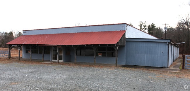
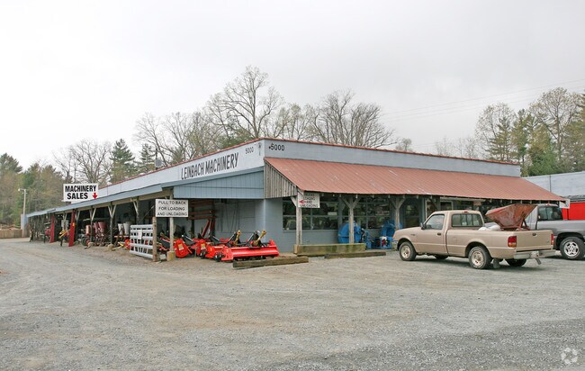
5000 Reynolda Rd
Greensboro/Winston-Salem
Leinbach Brothers Inc
Winston-Salem, NC
LEINBACH BROTHERS INC LO:120 BL:3599 BU:1
6808-52-2391
Forsyth
Commercialnec
North Carolina
2024
120
2025
14.02 AC
002604
NW Forsyth County
14,675 SF
DEMOGRAPHICS near 5000 Reynolda Rd
1 Mile
3 Mile
5 Mile
2024 Total Population
5,374
33,555
85,525
2029 Population
5,591
34,877
88,981
Pop Growth 2024-2029
+ 4.04%
+ 3.94%
+ 4.04%
Average Age
38
40
39
2024 Total Households
1,983
13,667
33,776
HH Growth 2024-2029
+ 4.08%
+ 3.91%
+ 4.16%
Median Household Inc
$75,264
$67,928
$69,104
Avg Household Size
2.60
2.40
2.30
2024 Avg HH Vehicles
2.00
2.00
2.00
Median Home Value
$219,062
$226,627
$249,176
Median Year Built
1990
1985
1983
Nearby Places
Map Layers
Map Styles
 Street
 Aerial
- Restaurants
- Banks
- Shops
- Fitness
- Groceries
PUBLIC TRANSPORTATION
AIRPORT
Piedmont Triad International
DRIVE
WALK
Distance
Piedmont Triad International
47 min
28.9 mi
Freight Ports
Virginia Port Authority - Richmond
DRIVE
WALK
Distance
Virginia Port Authority - Richmond
274 min
232.5 mi
Nearby Properties
Address
Land Use
TOTAL SIZE
Lot Size
Zoning
Address
Land Use
TOTAL SIZE
Lot Size
Zoning
329,963 SF
58.84 AC
RM18-S
Address
Land Use
TOTAL SIZE
Lot Size
Zoning
160,210 SF
33.21 AC
AG
Address
Land Use
TOTAL SIZE
Lot Size
Zoning
711,274 SF
38.24 AC
LI
Address
Land Use
TOTAL SIZE
Lot Size
Zoning
82,843 SF
16.06 AC
RM18
Address
Land Use
TOTAL SIZE
Lot Size
Zoning
67,643 SF
19.19 AC
RM12-S
Address
Land Use
TOTAL SIZE
Lot Size
Zoning
89,957 SF
14.65 AC
RM18
Address
Land Use
TOTAL SIZE
Lot Size
Zoning
93,541 SF
10.75 AC
RM18
Address
Land Use
TOTAL SIZE
Lot Size
Zoning
57,152 SF
9.82 AC
RM18-S
Address
Land Use
TOTAL SIZE
Lot Size
Zoning
95,375 SF
20.15 AC
RS9
Address
Land Use
TOTAL SIZE
Lot Size
Zoning
51,100 SF
11.29 AC
RM18-S
Address
Land Use
TOTAL SIZE
Lot Size
Zoning
56,653 SF
13.83 AC
RM12-S,RM1
Address
Land Use
TOTAL SIZE
Lot Size
Zoning
68,730 SF
8.97 AC
RM18
Address
Land Use
TOTAL SIZE
Lot Size
Zoning
79,327 SF
22.97 AC
RS9
Address
Land Use
TOTAL SIZE
Lot Size
Zoning
71,548 SF
11.15 AC
RM18
Address
Land Use
TOTAL SIZE
Lot Size
Zoning
45,326 SF
7.49 AC
RM18
Address
Land Use
TOTAL SIZE
Lot Size
Zoning
150,753 SF
11.49 AC
HB
Address
Land Use
TOTAL SIZE
Lot Size
Zoning
333.30 AC
GI-S
Address
Land Use
TOTAL SIZE
Lot Size
Zoning
81,703 SF
8.34 AC
HB
Address
Land Use
TOTAL SIZE
Lot Size
Zoning
198,668 SF
13.50 AC
RM12-S,RS9
Address
Land Use
TOTAL SIZE
Lot Size
Zoning
93,293 SF
16.48 AC
IP
Address
Land Use
TOTAL SIZE
Lot Size
Zoning
62,004 SF
6.15 AC
IP
Address
Land Use
TOTAL SIZE
Lot Size
Zoning
72,636 SF
35.84 AC
IP
Address
Land Use
TOTAL SIZE
Lot Size
Zoning
82,476 SF
3.96 AC
GO
Address
Land Use
TOTAL SIZE
Lot Size
Zoning
52,033 SF
18.16 AC
RS9
Address
Land Use
TOTAL SIZE
Lot Size
Zoning
60,556 SF
9.90 AC
LB
Address
Land Use
TOTAL SIZE
Lot Size
Zoning
72,644 SF
9.68 AC
HB
Address
Land Use
TOTAL SIZE
Lot Size
Zoning
84,234 SF
5.26 AC
LI
Address
Land Use
TOTAL SIZE
Lot Size
Zoning
104,748 SF
11.75 AC
HB
Address
Land Use
TOTAL SIZE
Lot Size
Zoning
29,325 SF
6.38 AC
RM18-S
Address
Land Use
TOTAL SIZE
Lot Size
Zoning
38,202 SF
16.62 AC
RM12-S
The World's #1 Commercial Real Estate Marketplace
Connect with us
© 2025 CoStar Group
The information above has been obtained from sources believed reliable. While we do not doubt its accuracy we have not verified it and make no guarantee, warranty or representation about it. It is your responsibility to independently confirm its accuracy and completeness. Any projections, opinions, assumptions, or estimates used are for example only and do not represent the current or future performance of the property. The value of this transaction to you depends on tax and other factors which should be evaluated by your tax, financial, and legal advisors. You and your advisors should conduct a careful, independent investigation of the property to determine to your satisfaction the suitability of the property for your needs.