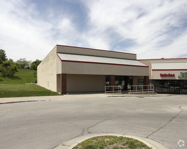
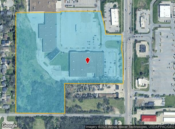
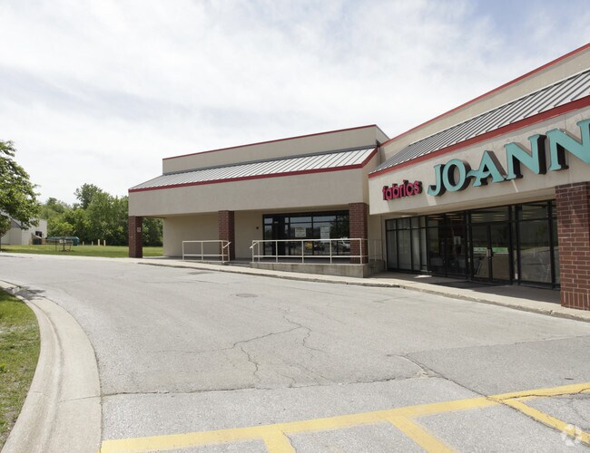
Property Record
5000 Se 14Th St, Des Moines, IA 50320

NEARBY LISTINGS FOR SALE OR LEASE
Property Detail
5000 Se 14Th St
Des Moines-West Des Moines, IA
Southdale
120-04690106000
LOT 6 SOUTHDALE
Regionalshoppingcenterormallwithanchorstore
Polk
X
Iowa
19153C0365F
6
2024
20.84 AC
2025
South
004602
Des Moines
147,173 SF
DEMOGRAPHICS near 5000 Se 14Th St
1 Mile
3 Mile
5 Mile
2024 Total Population
10,510
62,387
117,338
2029 Population
10,924
64,761
122,712
Pop Growth 2024-2029
+ 3.94%
+ 3.81%
+ 4.58%
Average Age
37
37
37
2024 Total Households
3,955
24,515
49,453
HH Growth 2024-2029
+ 4.10%
+ 4.04%
+ 4.90%
Median Household Inc
$55,976
$61,033
$56,049
Avg Household Size
2.60
2.50
2.30
2024 Avg HH Vehicles
2.00
2.00
2.00
Median Home Value
$147,280
$160,971
$162,405
Median Year Built
1973
1972
1972
Nearby Places
Map Layers
Map Styles
 Street
 Aerial
- Restaurants
- Banks
- Shops
- Fitness
- Groceries
PUBLIC TRANSPORTATION
AIRPORT
Des Moines International
DRIVE
WALK
Distance
Des Moines International
10 min
4.2 mi
SALE & LEASE HISTORY
LISTING DATE
SALE/LEASE

Sep 25, 2016
For Lease
Nearby Properties
Address
Land Use
TOTAL SIZE
Lot Size
Zoning
Address
Land Use
TOTAL SIZE
Lot Size
Zoning
162,217 SF
6.32 AC
Address
Land Use
TOTAL SIZE
Lot Size
Zoning
274,385 SF
3.83 AC
D-R
Address
Land Use
TOTAL SIZE
Lot Size
Zoning
208,456 SF
14.42 AC
PUD
Address
Land Use
TOTAL SIZE
Lot Size
Zoning
231,168 SF
22.29 AC
PUD
Address
Land Use
TOTAL SIZE
Lot Size
Zoning
260,420 SF
18.17 AC
R-3
Address
Land Use
TOTAL SIZE
Lot Size
Zoning
178,415 SF
13.35 AC
R-6
Address
Land Use
TOTAL SIZE
Lot Size
Zoning
74,760 SF
3.17 AC
Address
Land Use
TOTAL SIZE
Lot Size
Zoning
74,880 SF
0.45 AC
Address
Land Use
TOTAL SIZE
Lot Size
Zoning
67,080 SF
1.29 AC
Address
Land Use
TOTAL SIZE
Lot Size
Zoning
160,680 SF
20.08 AC
C-2
Address
Land Use
TOTAL SIZE
Lot Size
Zoning
658,855 SF
47.73 AC
M-1
Address
Land Use
TOTAL SIZE
Lot Size
Zoning
684,064 SF
2 AC
C-3
Address
Land Use
TOTAL SIZE
Lot Size
Zoning
155,640 SF
9.15 AC
R-6
Address
Land Use
TOTAL SIZE
Lot Size
Zoning
138,490 SF
10.01 AC
R-6
Address
Land Use
TOTAL SIZE
Lot Size
Zoning
51,965 SF
3.83 AC
C-4
Address
Land Use
TOTAL SIZE
Lot Size
Zoning
169,201 SF
13.66 AC
C-4
Address
Land Use
TOTAL SIZE
Lot Size
Zoning
82,044 SF
2.91 AC
Address
Land Use
TOTAL SIZE
Lot Size
Zoning
207,624 SF
8.35 AC
Address
Land Use
TOTAL SIZE
Lot Size
Zoning
58,366 SF
11.58 AC
Address
Land Use
TOTAL SIZE
Lot Size
Zoning
301,434 SF
29.03 AC
C4
Address
Land Use
TOTAL SIZE
Lot Size
Zoning
121,200 SF
10.32 AC
C-2
Address
Land Use
TOTAL SIZE
Lot Size
Zoning
178,721 SF
8.19 AC
C-2
Address
Land Use
TOTAL SIZE
Lot Size
Zoning
73,000 SF
4.07 AC
PUD
Address
Land Use
TOTAL SIZE
Lot Size
Zoning
310,851 SF
18.05 AC
C-4
Address
Land Use
TOTAL SIZE
Lot Size
Zoning
91,166 SF
C-4
Address
Land Use
TOTAL SIZE
Lot Size
Zoning
92,232 SF
6.01 AC
R-3
Address
Land Use
TOTAL SIZE
Lot Size
Zoning
110,260 SF
9.56 AC
PUD
Address
Land Use
TOTAL SIZE
Lot Size
Zoning
73,860 SF
2.52 AC
The World's #1 Commercial Real Estate Marketplace
Connect with us
© 2026 CoStar Group
The information above has been obtained from sources believed reliable. While we do not doubt its accuracy we have not verified it and make no guarantee, warranty or representation about it. It is your responsibility to independently confirm its accuracy and completeness. Any projections, opinions, assumptions, or estimates used are for example only and do not represent the current or future performance of the property. The value of this transaction to you depends on tax and other factors which should be evaluated by your tax, financial, and legal advisors. You and your advisors should conduct a careful, independent investigation of the property to determine to your satisfaction the suitability of the property for your needs.