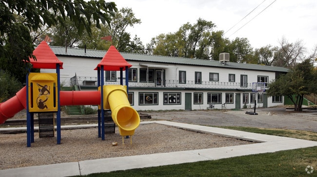
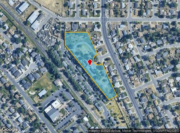
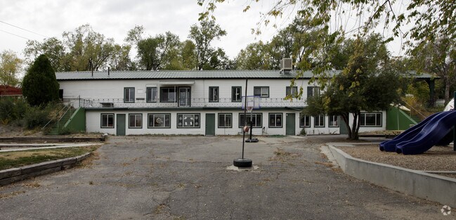
Property Record
5000 W 5035 S, Salt Lake City, UT 84118

NEARBY LISTINGS FOR SALE OR LEASE
Property Detail
5000 W 5035 S
20-12-426-002-0000
COM N 0^04 W 2666.55 FT & N 89^5430 W 1257.89 FT FR SE COR SEC 12 T 2S R 2W SL MER N 89^5430 W 227.74 FT S 0^0530 W 126.2 FT S 38^2330 E 704.58 FT N 65^3530 E 89.31 FT N 24^2430 W 704.09 FT TO BEG 3.13 AC. 5937-244 10275-1734
Daycare
Salt Lake
X
Utah
49035C0275G
3.13 AC
0
West Valley/Lake Park
2025
Salt Lake City
113802
Salt Lake City, UT
3,084 SF
DEMOGRAPHICS near 5000 W 5035 S
1 Mile
3 Mile
5 Mile
2024 Total Population
22,464
155,136
336,323
2029 Population
22,511
156,892
340,192
Pop Growth 2024-2029
+ 0.21%
+ 1.13%
+ 1.15%
Average Age
34
35
35
2024 Total Households
6,054
43,853
99,335
HH Growth 2024-2029
+ 0.08%
+ 1.05%
+ 1.09%
Median Household Inc
$69,662
$82,345
$81,589
Avg Household Size
3.50
3.40
3.30
2024 Avg HH Vehicles
2.00
2.00
2.00
Median Home Value
$303,930
$345,871
$363,482
Median Year Built
1971
1982
1986
Nearby Places
Map Layers
Map Styles
 Street
 Aerial
- Restaurants
- Banks
- Shops
- Fitness
- Groceries
PUBLIC TRANSPORTATION
AIRPORT
Salt Lake City International
DRIVE
WALK
Distance
Salt Lake City International
18 min
10.3 mi
Freight Ports
Port of Stockton
DRIVE
WALK
Distance
Port of Stockton
714 min
694.6 mi
Nearby Properties
Address
Land Use
TOTAL SIZE
Lot Size
Zoning
Address
Land Use
TOTAL SIZE
Lot Size
Zoning
895,175 SF
28.95 AC
SSD-X
Address
Land Use
TOTAL SIZE
Lot Size
Zoning
1,113,459 SF
80.09 AC
M
Address
Land Use
TOTAL SIZE
Lot Size
Zoning
187.81 AC
P-F
Address
Land Use
TOTAL SIZE
Lot Size
Zoning
329,306 SF
14.67 AC
5005
Address
Land Use
TOTAL SIZE
Lot Size
Zoning
187,717 SF
15.02 AC
R-M
Address
Land Use
TOTAL SIZE
Lot Size
Zoning
63,758 SF
13.93 AC
RM
Address
Land Use
TOTAL SIZE
Lot Size
Zoning
40,042 SF
15.43 AC
R-3-16
Address
Land Use
TOTAL SIZE
Lot Size
Zoning
289,725 SF
8.42 AC
1108
Address
Land Use
TOTAL SIZE
Lot Size
Zoning
250,027 SF
8.46 AC
PF
Address
Land Use
TOTAL SIZE
Lot Size
Zoning
57,772 SF
8.09 AC
MU
Address
Land Use
TOTAL SIZE
Lot Size
Zoning
186,337 SF
20 AC
1107
Address
Land Use
TOTAL SIZE
Lot Size
Zoning
314,994 SF
10 AC
R-3
Address
Land Use
TOTAL SIZE
Lot Size
Zoning
330,834 SF
7.60 AC
R-1-8
Address
Land Use
TOTAL SIZE
Lot Size
Zoning
80 AC
PF
Address
Land Use
TOTAL SIZE
Lot Size
Zoning
297,972 SF
45.67 AC
M
Address
Land Use
TOTAL SIZE
Lot Size
Zoning
72 AC
2000
Address
Land Use
TOTAL SIZE
Lot Size
Zoning
71,093 SF
29.58 AC
PF
Address
Land Use
TOTAL SIZE
Lot Size
Zoning
205,091 SF
15.71 AC
R-3-16
Address
Land Use
TOTAL SIZE
Lot Size
Zoning
281,172 SF
12.91 AC
MI
Address
Land Use
TOTAL SIZE
Lot Size
Zoning
244,871 SF
14.53 AC
4144
Address
Land Use
TOTAL SIZE
Lot Size
Zoning
162,248 SF
29.60 AC
PO
Address
Land Use
TOTAL SIZE
Lot Size
Zoning
350,675 SF
36.41 AC
M
Address
Land Use
TOTAL SIZE
Lot Size
Zoning
342.97 AC
M
Address
Land Use
TOTAL SIZE
Lot Size
Zoning
12,118 SF
9.86 AC
RM
Address
Land Use
TOTAL SIZE
Lot Size
Zoning
95,998 SF
9.46 AC
1107
Address
Land Use
TOTAL SIZE
Lot Size
Zoning
391,140 SF
17.41 AC
M
Address
Land Use
TOTAL SIZE
Lot Size
Zoning
131,159 SF
14 AC
5306
Address
Land Use
TOTAL SIZE
Lot Size
Zoning
338,098 SF
7.24 AC
SSD-X
Address
Land Use
TOTAL SIZE
Lot Size
Zoning
171,937 SF
24.21 AC
R-1-8
Address
Land Use
TOTAL SIZE
Lot Size
Zoning
60,295 SF
41.98 AC
4144
The World's #1 Commercial Real Estate Marketplace
Connect with us
© 2025 CoStar Group
The information above has been obtained from sources believed reliable. While we do not doubt its accuracy we have not verified it and make no guarantee, warranty or representation about it. It is your responsibility to independently confirm its accuracy and completeness. Any projections, opinions, assumptions, or estimates used are for example only and do not represent the current or future performance of the property. The value of this transaction to you depends on tax and other factors which should be evaluated by your tax, financial, and legal advisors. You and your advisors should conduct a careful, independent investigation of the property to determine to your satisfaction the suitability of the property for your needs.