Property Record
5001 E W Ave N, Palmdale, CA 93551


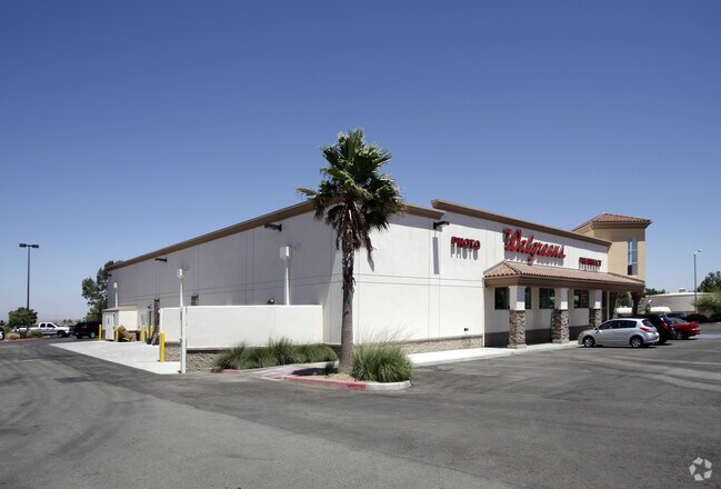

Property Detail
5001 E W Ave N
3101-048-003
PM 348-89-91 LOT 3
Storemultistory
LOS ANGELES
PDLCC
California
B and X Area of moderate flood hazard, usually the area between the limits of the 100-year and 500-year floods.
3
2024
1.14 AC
2025
Antelope Valley
910216
Los Angeles
13,565 SF
Los Angeles-Long Beach-Glendale, CA
NEARBY LISTINGS FOR SALE OR LEASE
DEMOGRAPHICS near 5001 E W Ave N
1 mile
3 mile
5 mile
2025 Total Population
10,466
52,512
117,393
2030 Population
10,376
52,280
117,440
Pop Growth 2025-2030
(0.86%)
(0.44%)
+ 0.04%
Average Age
42
41
39
2025 Total Households
3,495
17,135
38,657
HH Growth 2025-2030
(1.09%)
(0.56%)
(0.01%)
Median Household Inc
$112,366
$110,063
$102,535
Avg Household Size
3.00
3.00
3.00
2025 Avg HH Vehicles
2.00
2.00
2.00
Median Home Value
$643,734
$619,579
$588,315
Median Year Built
1988
1991
1991
Nearby Places
Map Layers
Map Styles
 Street
 Aerial
Layers
 Traffic
 Biking
Places
Listings with unknown addresses are not visible on the map
- Restaurants
- Banks
- Shops
- Fitness
- Groceries
PUBLIC TRANSPORTATION
COMMUTER RAIL
Palmdale (Antelope Valley Line - Southern California Regional Rail Authority (Metrolink))
Drive
Walk
Distance
Palmdale (Antelope Valley Line - Southern California Regional Rail Authority (Metrolink))
14 min
7.7 mi
Lancaster (Antelope Valley Line - Southern California Regional Rail Authority (Metrolink))
Drive
Walk
Distance
Lancaster (Antelope Valley Line - Southern California Regional Rail Authority (Metrolink))
16 min
9.8 mi
Nearby Properties
Address
Land Use
TOTAL SIZE
Lot Size
Zoning
Address
Land Use
TOTAL SIZE
Lot Size
Zoning
69,157 SF
PDSP*
Address
Land Use
TOTAL SIZE
Lot Size
Zoning
58,043 SF
5.94 AC
PDC3
Address
Land Use
TOTAL SIZE
Lot Size
Zoning
189,762 SF
4.58 AC
PDR3-C1*
Address
Land Use
TOTAL SIZE
Lot Size
Zoning
62,739 SF
18.53 AC
LRA22
Address
Land Use
TOTAL SIZE
Lot Size
Zoning
46,328 SF
4.78 AC
LCR1 10000
Address
Land Use
TOTAL SIZE
Lot Size
Zoning
67,985 SF
3.34 AC
LCRA10000*
Address
Land Use
TOTAL SIZE
Lot Size
Zoning
43,255 SF
3.92 AC
LRC1DP*
Address
Land Use
TOTAL SIZE
Lot Size
Zoning
41,356 SF
4.76 AC
PDSP
Address
Land Use
TOTAL SIZE
Lot Size
Zoning
36,115 SF
13.25 AC
LCA210
Address
Land Use
TOTAL SIZE
Lot Size
Zoning
105,077 SF
13.27 AC
LCC1-LCR3*
Address
Land Use
TOTAL SIZE
Lot Size
Zoning
23,581 SF
4.81 AC
LRA22*
Address
Land Use
TOTAL SIZE
Lot Size
Zoning
72,584 SF
2.01 AC
LCR1 10000
Address
Land Use
TOTAL SIZE
Lot Size
Zoning
10,000 SF
1.48 AC
LCC2
Address
Land Use
TOTAL SIZE
Lot Size
Zoning
105,212 SF
19.15 AC
LRSRR*
Address
Land Use
TOTAL SIZE
Lot Size
Zoning
27,821 SF
1.09 AC
LCR3P*
Address
Land Use
TOTAL SIZE
Lot Size
Zoning
66,192 SF
1.63 AC
PDR3-C1*
Address
Land Use
TOTAL SIZE
Lot Size
Zoning
41,990 SF
1.21 AC
LCR1 10000
Address
Land Use
TOTAL SIZE
Lot Size
Zoning
15,108 SF
1.91 AC
LRCPD*
Address
Land Use
TOTAL SIZE
Lot Size
Zoning
138,009 SF
12.01 AC
LCR3*
Address
Land Use
TOTAL SIZE
Lot Size
Zoning
44,160 SF
5.51 AC
LCR3-2DU-D
Address
Land Use
TOTAL SIZE
Lot Size
Zoning
6 AC
PDC3
Address
Land Use
TOTAL SIZE
Lot Size
Zoning
7,396 SF
1.34 AC
LCMX-DRU
Address
Land Use
TOTAL SIZE
Lot Size
Zoning
19,401 SF
1.81 AC
LCC4
Address
Land Use
TOTAL SIZE
Lot Size
Zoning
77,586 SF
9.49 AC
LCR3*
Address
Land Use
TOTAL SIZE
Lot Size
Zoning
12.44 AC
PDC1*
Address
Land Use
TOTAL SIZE
Lot Size
Zoning
17,515 SF
1.25 AC
PDC3
Address
Land Use
TOTAL SIZE
Lot Size
Zoning
61,367 SF
1.51 AC
PDR3-C1*
Address
Land Use
TOTAL SIZE
Lot Size
Zoning
1,862 SF
9.24 AC
LRCP
Address
Land Use
TOTAL SIZE
Lot Size
Zoning
7,980 SF
0.70 AC
LCR1 10000
The World's #1 Commercial Real Estate Marketplace
Connect with us
© 2026 CoStar Group
The information above has been obtained from sources believed reliable. While we do not doubt its accuracy we have not verified it and make no guarantee, warranty or representation about it. It is your responsibility to independently confirm its accuracy and completeness. Any projections, opinions, assumptions, or estimates used are for example only and do not represent the current or future performance of the property. The value of this transaction to you depends on tax and other factors which should be evaluated by your tax, financial, and legal advisors. You and your advisors should conduct a careful, independent investigation of the property to determine to your satisfaction the suitability of the property for your needs.