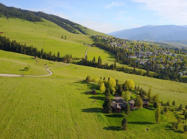
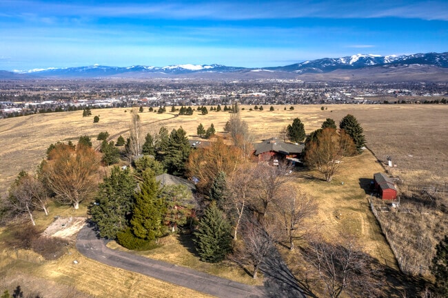
Property Record
1990 Rimel Rd, Missoula, MT 59803


NEARBY LISTINGS FOR SALE OR LEASE
Property Detail
1990 Rimel Rd
Missoula, MT
C-G-1 Certificate/Surv 2412
04-2093-06-4-10-01-0000
S06, T12 N, R19 W, C.O.S. 2412, PARCEL C-G-1, ACRES 23.84
Multifamilydwelling
Missoula
X
Montana
30063C1460E
cg1
2024
23.84 AC
2025
Missoula
001302
Other Market Areas
160,371 SF
DEMOGRAPHICS near 1990 Rimel Rd
1 Mile
3 Mile
5 Mile
2024 Total Population
9,286
44,882
82,332
2029 Population
10,016
48,396
89,005
Pop Growth 2024-2029
+ 7.86%
+ 7.83%
+ 8.10%
Average Age
40
38
38
2024 Total Households
3,599
18,894
36,584
HH Growth 2024-2029
+ 7.97%
+ 7.90%
+ 8.29%
Median Household Inc
$82,092
$70,929
$61,814
Avg Household Size
2.50
2.30
2.10
2024 Avg HH Vehicles
2.00
2.00
2.00
Median Home Value
$353,493
$384,121
$374,999
Median Year Built
1979
1977
1981
Nearby Places
Map Layers
Map Styles
 Street
 Aerial
- Restaurants
- Banks
- Shops
- Fitness
- Groceries
PUBLIC TRANSPORTATION
AIRPORT
Missoula Montana
DRIVE
WALK
Distance
Missoula Montana
17 min
8.7 mi
Freight Ports
Port of Everett
DRIVE
WALK
Distance
Port of Everett
557 min
503.5 mi
SALE & LEASE HISTORY
LISTING DATE
SALE/LEASE

Mar 09, 2020
For Sale
Jul 25, 2017
For Sale
Nearby Properties
Address
Land Use
TOTAL SIZE
Lot Size
Zoning
Address
Land Use
TOTAL SIZE
Lot Size
Zoning
243,789 SF
11.95 AC
Address
Land Use
TOTAL SIZE
Lot Size
Zoning
334,916 SF
24 AC
Address
Land Use
TOTAL SIZE
Lot Size
Zoning
194,576 SF
15.35 AC
8
Address
Land Use
TOTAL SIZE
Lot Size
Zoning
50,493 SF
2.20 AC
1
Address
Land Use
TOTAL SIZE
Lot Size
Zoning
107,422 SF
6.90 AC
Address
Land Use
TOTAL SIZE
Lot Size
Zoning
66.44 AC
1
Address
Land Use
TOTAL SIZE
Lot Size
Zoning
147,269 SF
25.16 AC
1
Address
Land Use
TOTAL SIZE
Lot Size
Zoning
31,523 SF
5 AC
Address
Land Use
TOTAL SIZE
Lot Size
Zoning
61.94 AC
Address
Land Use
TOTAL SIZE
Lot Size
Zoning
103,964 SF
7.62 AC
Address
Land Use
TOTAL SIZE
Lot Size
Zoning
130,553 SF
9.65 AC
5
Address
Land Use
TOTAL SIZE
Lot Size
Zoning
42,084 SF
1.71 AC
6
Address
Land Use
TOTAL SIZE
Lot Size
Zoning
76,320 SF
6 AC
9
Address
Land Use
TOTAL SIZE
Lot Size
Zoning
26,245 SF
1.50 AC
1
Address
Land Use
TOTAL SIZE
Lot Size
Zoning
65,152 SF
11.52 AC
1
Address
Land Use
TOTAL SIZE
Lot Size
Zoning
13,958 SF
5.01 AC
Address
Land Use
TOTAL SIZE
Lot Size
Zoning
78,000 SF
0.57 AC
3
Address
Land Use
TOTAL SIZE
Lot Size
Zoning
104,202 SF
7.76 AC
Address
Land Use
TOTAL SIZE
Lot Size
Zoning
74,936 SF
5 AC
6
Address
Land Use
TOTAL SIZE
Lot Size
Zoning
10.08 AC
Address
Land Use
TOTAL SIZE
Lot Size
Zoning
95,266 SF
5.03 AC
6
Address
Land Use
TOTAL SIZE
Lot Size
Zoning
140,308 SF
5.46 AC
Address
Land Use
TOTAL SIZE
Lot Size
Zoning
42,586 SF
2.67 AC
1
Address
Land Use
TOTAL SIZE
Lot Size
Zoning
57,559 SF
4.90 AC
Address
Land Use
TOTAL SIZE
Lot Size
Zoning
56,912 SF
5.63 AC
3
Address
Land Use
TOTAL SIZE
Lot Size
Zoning
0.06 AC
1
Address
Land Use
TOTAL SIZE
Lot Size
Zoning
29,068 SF
0.72 AC
1
Address
Land Use
TOTAL SIZE
Lot Size
Zoning
104,336 SF
8.51 AC
1
The World's #1 Commercial Real Estate Marketplace
Connect with us
© 2025 CoStar Group
The information above has been obtained from sources believed reliable. While we do not doubt its accuracy we have not verified it and make no guarantee, warranty or representation about it. It is your responsibility to independently confirm its accuracy and completeness. Any projections, opinions, assumptions, or estimates used are for example only and do not represent the current or future performance of the property. The value of this transaction to you depends on tax and other factors which should be evaluated by your tax, financial, and legal advisors. You and your advisors should conduct a careful, independent investigation of the property to determine to your satisfaction the suitability of the property for your needs.