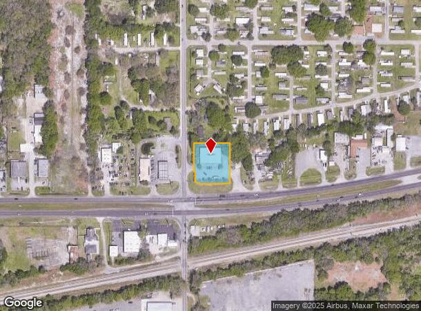
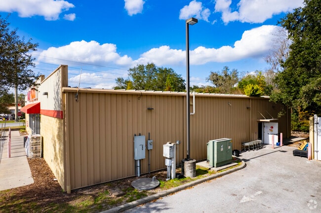
Property Record
5002 Us Highway 92 W, Auburndale, FL 33823

NEARBY LISTINGS FOR SALE OR LEASE
Property Detail
5002 Us Highway 92 W
25-28-18-000000-034020
Kimberely Acres
Storebuilding
W 220 FT OF SW1/4 OF NW1/4 N OF SR 600 FT LESS N 990 FT & LESS R/W DIXIE HWY & LESS ADDL RW AS DESC IN OR BK 8856 PG 1531
X
Polk
12105C0340G
Florida
2024
0.82 AC
2025
Polk County
011604
Tampa/St Petersburg
8,480 SF
Lakeland-Winter Haven, FL
DEMOGRAPHICS near 5002 Us Highway 92 W
1 Mile
3 Mile
5 Mile
2024 Total Population
3,542
20,089
60,123
2029 Population
4,267
24,138
71,959
Pop Growth 2024-2029
+ 20.47%
+ 20.16%
+ 19.69%
Average Age
48
43
40
2024 Total Households
1,552
8,119
22,896
HH Growth 2024-2029
+ 20.55%
+ 20.30%
+ 19.73%
Median Household Inc
$50,706
$46,011
$47,261
Avg Household Size
2.20
2.40
2.50
2024 Avg HH Vehicles
1.00
2.00
2.00
Median Home Value
$76,761
$89,192
$138,277
Median Year Built
1991
1984
1980
Nearby Places
Map Layers
Map Styles
 Street
 Aerial
- Restaurants
- Banks
- Shops
- Fitness
- Groceries
PUBLIC TRANSPORTATION
COMMUTER RAIL
Lakeland (Silver Star - Amtrak)
DRIVE
WALK
Distance
Lakeland (Silver Star - Amtrak)
10 min
6.1 mi
Freight Ports
Port of Tampa Bay
DRIVE
WALK
Distance
Port of Tampa Bay
55 min
40.1 mi
Nearby Properties
Address
Land Use
TOTAL SIZE
Lot Size
Zoning
Address
Land Use
TOTAL SIZE
Lot Size
Zoning
831,600 SF
51.22 AC
Address
Land Use
TOTAL SIZE
Lot Size
Zoning
811,392 SF
47.70 AC
Address
Land Use
TOTAL SIZE
Lot Size
Zoning
275,220 SF
94.53 AC
Address
Land Use
TOTAL SIZE
Lot Size
Zoning
188,553 SF
29.12 AC
Address
Land Use
TOTAL SIZE
Lot Size
Zoning
84,129 SF
336.67 AC
Address
Land Use
TOTAL SIZE
Lot Size
Zoning
135,247 SF
22.49 AC
C4
Address
Land Use
TOTAL SIZE
Lot Size
Zoning
72,853 SF
6.78 AC
C3
Address
Land Use
TOTAL SIZE
Lot Size
Zoning
126,384 SF
4.67 AC
CH
Address
Land Use
TOTAL SIZE
Lot Size
Zoning
100,000 SF
58.51 AC
RE2
Address
Land Use
TOTAL SIZE
Lot Size
Zoning
147,180 SF
11.44 AC
C4
Address
Land Use
TOTAL SIZE
Lot Size
Zoning
117,592 SF
10.02 AC
GI
Address
Land Use
TOTAL SIZE
Lot Size
Zoning
80,280 SF
25.05 AC
Address
Land Use
TOTAL SIZE
Lot Size
Zoning
79,856 SF
14.14 AC
Address
Land Use
TOTAL SIZE
Lot Size
Zoning
77,279 SF
12.12 AC
Address
Land Use
TOTAL SIZE
Lot Size
Zoning
113,410 SF
19.78 AC
C4
Address
Land Use
TOTAL SIZE
Lot Size
Zoning
Address
Land Use
TOTAL SIZE
Lot Size
Zoning
66,000 SF
8.33 AC
Address
Land Use
TOTAL SIZE
Lot Size
Zoning
80,160 SF
2.79 AC
C4
Address
Land Use
TOTAL SIZE
Lot Size
Zoning
30,898 SF
7.27 AC
Address
Land Use
TOTAL SIZE
Lot Size
Zoning
54,204 SF
9.09 AC
Address
Land Use
TOTAL SIZE
Lot Size
Zoning
70,370 SF
4.86 AC
GI
Address
Land Use
TOTAL SIZE
Lot Size
Zoning
17,688 SF
3.16 AC
C3
Address
Land Use
TOTAL SIZE
Lot Size
Zoning
53,000 SF
5.15 AC
GI
Address
Land Use
TOTAL SIZE
Lot Size
Zoning
51,059 SF
14.36 AC
XX
Address
Land Use
TOTAL SIZE
Lot Size
Zoning
178,950 SF
23.99 AC
PUD
Address
Land Use
TOTAL SIZE
Lot Size
Zoning
35,397 SF
1.90 AC
Address
Land Use
TOTAL SIZE
Lot Size
Zoning
91,080 SF
10.22 AC
GI
Address
Land Use
TOTAL SIZE
Lot Size
Zoning
6,032 SF
2.26 AC
Address
Land Use
TOTAL SIZE
Lot Size
Zoning
62,020 SF
21.99 AC
Address
Land Use
TOTAL SIZE
Lot Size
Zoning
17,760 SF
2.62 AC
The World's #1 Commercial Real Estate Marketplace
Connect with us
© 2025 CoStar Group
The information above has been obtained from sources believed reliable. While we do not doubt its accuracy we have not verified it and make no guarantee, warranty or representation about it. It is your responsibility to independently confirm its accuracy and completeness. Any projections, opinions, assumptions, or estimates used are for example only and do not represent the current or future performance of the property. The value of this transaction to you depends on tax and other factors which should be evaluated by your tax, financial, and legal advisors. You and your advisors should conduct a careful, independent investigation of the property to determine to your satisfaction the suitability of the property for your needs.