Property Record
5003 Turnbridge Cir, Browns Summit, NC 27214
NEARBY LISTINGS FOR SALE OR LEASE
-
-
View all Browns Summit listings for sale on LoopNet.com
Property Detail
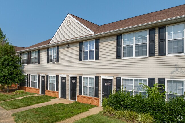
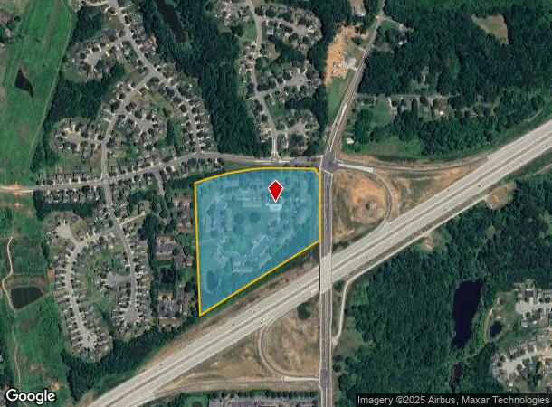
5003 Turnbridge Cir
0091120
Turnbridge Ph I Apts
Apartment
14.69AC 1 PB118-149 TURN- BRIDGE APTS PL:118-149
X
Guilford
3710787700J
North Carolina
2024
14.69 AC
2025
Outer Guilford
015500
Greensboro/Winston-Salem
61,440 SF
Greensboro-High Point, NC
DEMOGRAPHICS near 5003 Turnbridge Cir
1 mile
3 mile
5 mile
2024 Total Population
8,256
51,347
113,779
2029 Population
8,192
51,241
113,688
Pop Growth 2024-2029
(0.78%)
(0.21%)
(0.08%)
Average Age
36
39
39
2024 Total Households
3,144
21,006
47,052
HH Growth 2024-2029
(0.80%)
(0.27%)
(0.13%)
Median Household Inc
$62,687
$58,649
$59,372
Avg Household Size
2.50
2.40
2.30
2024 Avg HH Vehicles
2.00
2.00
2.00
Median Home Value
$178,210
$192,666
$206,508
Median Year Built
1997
1989
1983
Nearby Places
Map Layers
Map Styles
 Street
 Aerial
Transit
 Traffic
 Biking
Places
Listings with unknown addresses are not visible on the map
- Restaurants
- Banks
- Shops
- Fitness
- Groceries
PUBLIC TRANSPORTATION
COMMUTER RAIL
Greensboro Station (Piedmont - North Carolina by Train (NC Train))
Drive
Walk
Distance
Greensboro Station (Piedmont - North Carolina by Train (NC Train))
13 min
6.8 mi
AIRPORT
Piedmont Triad International
Drive
Walk
Distance
Piedmont Triad International
20 min
12.4 mi
Freight Ports
Virginia Port Authority - Richmond
Drive
Walk
Distance
Virginia Port Authority - Richmond
230 min
200.8 mi
Nearby Properties
Address
Land Use
TOTAL SIZE
Lot Size
Zoning
Address
Land Use
TOTAL SIZE
Lot Size
Zoning
262,390 SF
30.37 AC
RM-12
Address
Land Use
TOTAL SIZE
Lot Size
Zoning
223,891 SF
10.53 AC
PUD
Address
Land Use
TOTAL SIZE
Lot Size
Zoning
281,337 SF
20.64 AC
PUD
Address
Land Use
TOTAL SIZE
Lot Size
Zoning
252,109 SF
8.83 AC
PUD
Address
Land Use
TOTAL SIZE
Lot Size
Zoning
336,133 SF
23.93 AC
CU-RM-12
Address
Land Use
TOTAL SIZE
Lot Size
Zoning
171,358 SF
11.91 AC
PUD
Address
Land Use
TOTAL SIZE
Lot Size
Zoning
232,100 SF
12.41 AC
RM-12
Address
Land Use
TOTAL SIZE
Lot Size
Zoning
504,000 SF
42.01 AC
HI
Address
Land Use
TOTAL SIZE
Lot Size
Zoning
584,848 SF
32.91 AC
HI
Address
Land Use
TOTAL SIZE
Lot Size
Zoning
270,848 SF
18.28 AC
RM-18
Address
Land Use
TOTAL SIZE
Lot Size
Zoning
214,583 SF
20.64 AC
C-H
Address
Land Use
TOTAL SIZE
Lot Size
Zoning
259,434 SF
23.69 AC
RM-12
Address
Land Use
TOTAL SIZE
Lot Size
Zoning
38,940 SF
19.33 AC
R-3
Address
Land Use
TOTAL SIZE
Lot Size
Zoning
168,798 SF
15.45 AC
RM-12
Address
Land Use
TOTAL SIZE
Lot Size
Zoning
236,995 SF
14.09 AC
RM-18
Address
Land Use
TOTAL SIZE
Lot Size
Zoning
204,260 SF
11.83 AC
RM-18
Address
Land Use
TOTAL SIZE
Lot Size
Zoning
99,926 SF
8.13 AC
O
Address
Land Use
TOTAL SIZE
Lot Size
Zoning
189,979 SF
44.76 AC
PI
Address
Land Use
TOTAL SIZE
Lot Size
Zoning
191,654 SF
11.31 AC
RM-12
Address
Land Use
TOTAL SIZE
Lot Size
Zoning
119,780 SF
8.50 AC
PUD
Address
Land Use
TOTAL SIZE
Lot Size
Zoning
127,976 SF
40.04 AC
R-3
Address
Land Use
TOTAL SIZE
Lot Size
Zoning
227,536 SF
20.57 AC
RM-12
Address
Land Use
TOTAL SIZE
Lot Size
Zoning
103,218 SF
11.65 AC
RM-12
Address
Land Use
TOTAL SIZE
Lot Size
Zoning
65,185 SF
26.29 AC
R-3
Address
Land Use
TOTAL SIZE
Lot Size
Zoning
257,713 SF
24.07 AC
HI
Address
Land Use
TOTAL SIZE
Lot Size
Zoning
110,908 SF
10.10 AC
C-H
Address
Land Use
TOTAL SIZE
Lot Size
Zoning
243,880 SF
29.56 AC
HI
Address
Land Use
TOTAL SIZE
Lot Size
Zoning
18.71 AC
R-3
Address
Land Use
TOTAL SIZE
Lot Size
Zoning
137,573 SF
14.01 AC
C-H
Address
Land Use
TOTAL SIZE
Lot Size
Zoning
272,415 SF
13.02 AC
RM-12
The World's #1 Commercial Real Estate Marketplace
Connect with us
© 2026 CoStar Group
The information above has been obtained from sources believed reliable. While we do not doubt its accuracy we have not verified it and make no guarantee, warranty or representation about it. It is your responsibility to independently confirm its accuracy and completeness. Any projections, opinions, assumptions, or estimates used are for example only and do not represent the current or future performance of the property. The value of this transaction to you depends on tax and other factors which should be evaluated by your tax, financial, and legal advisors. You and your advisors should conduct a careful, independent investigation of the property to determine to your satisfaction the suitability of the property for your needs.