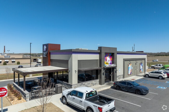
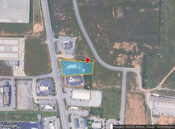
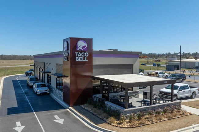
Property Record
5005 Highway 31, Calera, AL 35040
NEARBY LISTINGS FOR SALE OR LEASE
Property Detail
5005 Highway 31
28-2-04-0-001-010-006
Taco Bell Calera No 1
Officebuilding
COM SE COR NE1/4 N700 W1300 TOPOB W300 TO E ROW HWY31 N ALG ROW 329.2 E384.6 S318.14 TO POB
X
Shelby
01117C0413E
Alabama
2024
2.50 AC
2024
I-65 Corr/S Shelby County
030502
Birmingham
720 SF
Birmingham-Hoover, AL
DEMOGRAPHICS near 5005 Highway 31
1 Mile
3 Mile
5 Mile
2024 Total Population
807
13,656
27,403
2029 Population
882
14,865
29,966
Pop Growth 2024-2029
+ 9.29%
+ 8.85%
+ 9.35%
Average Age
38
36
37
2024 Total Households
298
5,172
10,229
HH Growth 2024-2029
+ 9.40%
+ 8.99%
+ 9.48%
Median Household Inc
$68,055
$75,196
$73,415
Avg Household Size
2.70
2.60
2.60
2024 Avg HH Vehicles
2.00
2.00
2.00
Median Home Value
$253,846
$197,076
$214,452
Median Year Built
1998
2004
2003
Nearby Places
Map Layers
Map Styles
 Street
 Aerial
- Restaurants
- Banks
- Shops
- Fitness
- Groceries
PUBLIC TRANSPORTATION
AIRPORT
Birmingham-Shuttlesworth International
DRIVE
WALK
Distance
Birmingham-Shuttlesworth International
44 min
35.1 mi
Freight Ports
Port of Mobile
DRIVE
WALK
Distance
Port of Mobile
248 min
227.4 mi
SALE & LEASE HISTORY
LISTING DATE
SALE/LEASE

Feb 06, 2024
For Sale
Nearby Properties
Address
Land Use
TOTAL SIZE
Lot Size
Zoning
Address
Land Use
TOTAL SIZE
Lot Size
Zoning
14,160 SF
6.75 AC
Address
Land Use
TOTAL SIZE
Lot Size
Zoning
139,905 SF
34.78 AC
Address
Land Use
TOTAL SIZE
Lot Size
Zoning
1,456 SF
20.58 AC
Address
Land Use
TOTAL SIZE
Lot Size
Zoning
573,600 SF
19.96 AC
Address
Land Use
TOTAL SIZE
Lot Size
Zoning
3,941 SF
5.60 AC
Address
Land Use
TOTAL SIZE
Lot Size
Zoning
500,500 SF
17.45 AC
Address
Land Use
TOTAL SIZE
Lot Size
Zoning
368,066 SF
20.66 AC
Address
Land Use
TOTAL SIZE
Lot Size
Zoning
270,600 SF
21.75 AC
Address
Land Use
TOTAL SIZE
Lot Size
Zoning
249,500 SF
16.15 AC
Address
Land Use
TOTAL SIZE
Lot Size
Zoning
6,234 SF
33 AC
Address
Land Use
TOTAL SIZE
Lot Size
Zoning
208,000 SF
11.91 AC
Address
Land Use
TOTAL SIZE
Lot Size
Zoning
46,031 SF
11.09 AC
Address
Land Use
TOTAL SIZE
Lot Size
Zoning
116,219 SF
35.20 AC
Address
Land Use
TOTAL SIZE
Lot Size
Zoning
85,144 SF
2.94 AC
Address
Land Use
TOTAL SIZE
Lot Size
Zoning
104,643 SF
5.39 AC
Address
Land Use
TOTAL SIZE
Lot Size
Zoning
53,022 SF
2.20 AC
Address
Land Use
TOTAL SIZE
Lot Size
Zoning
8,328 SF
6.89 AC
Address
Land Use
TOTAL SIZE
Lot Size
Zoning
241.36 AC
Address
Land Use
TOTAL SIZE
Lot Size
Zoning
73,825 SF
15 AC
Address
Land Use
TOTAL SIZE
Lot Size
Zoning
6,275 SF
290 AC
Address
Land Use
TOTAL SIZE
Lot Size
Zoning
14,163 SF
12.78 AC
Address
Land Use
TOTAL SIZE
Lot Size
Zoning
38,429 SF
4.28 AC
Address
Land Use
TOTAL SIZE
Lot Size
Zoning
30,000 SF
10.06 AC
Address
Land Use
TOTAL SIZE
Lot Size
Zoning
38,816 SF
33.96 AC
Address
Land Use
TOTAL SIZE
Lot Size
Zoning
36,430 SF
4.10 AC
Address
Land Use
TOTAL SIZE
Lot Size
Zoning
66,260 SF
3.84 AC
Address
Land Use
TOTAL SIZE
Lot Size
Zoning
14,700 SF
12 AC
Address
Land Use
TOTAL SIZE
Lot Size
Zoning
202 AC
The World's #1 Commercial Real Estate Marketplace
Connect with us
© 2025 CoStar Group
The information above has been obtained from sources believed reliable. While we do not doubt its accuracy we have not verified it and make no guarantee, warranty or representation about it. It is your responsibility to independently confirm its accuracy and completeness. Any projections, opinions, assumptions, or estimates used are for example only and do not represent the current or future performance of the property. The value of this transaction to you depends on tax and other factors which should be evaluated by your tax, financial, and legal advisors. You and your advisors should conduct a careful, independent investigation of the property to determine to your satisfaction the suitability of the property for your needs.