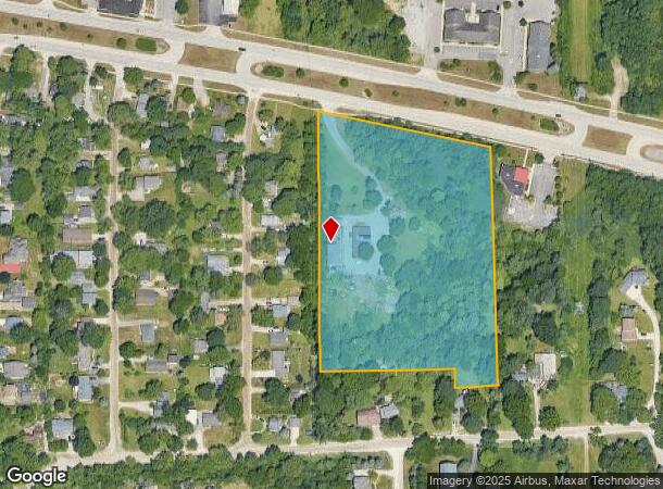
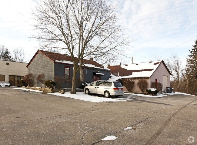
Property Record
5005 Jackson Rd, Ann Arbor, MI 48103

NEARBY LISTINGS FOR SALE OR LEASE
Property Detail
5005 Jackson Rd
08-22-480-021
COM AT S 1/4 POST, TH E 620.84 FT ON S LN OF SEC, TH DEFL 86 DEG 50' LFT 200 FT TO POB, TH DEFL 86 DEG 50' RT 371.6 FT, TH
Commercialnec
Washtenaw
AE
Michigan
26161C0240E
7.65 AC
2025
Washtenaw W of 23
2025
Detroit
456000
Ann Arbor, MI
4,800 SF
DEMOGRAPHICS near 5005 Jackson Rd
1 Mile
3 Mile
5 Mile
2024 Total Population
3,838
27,062
98,692
2029 Population
3,831
26,816
97,896
Pop Growth 2024-2029
(0.18%)
(0.91%)
(0.81%)
Average Age
41
41
37
2024 Total Households
1,495
11,480
39,994
HH Growth 2024-2029
(0.20%)
(0.95%)
(0.75%)
Median Household Inc
$141,725
$105,828
$85,922
Avg Household Size
2.50
2.30
2.20
2024 Avg HH Vehicles
2.00
2.00
2.00
Median Home Value
$481,960
$417,113
$429,245
Median Year Built
1996
1984
1977
Nearby Places
Map Layers
Map Styles
 Street
 Aerial
- Restaurants
- Banks
- Shops
- Fitness
- Groceries
PUBLIC TRANSPORTATION
COMMUTER RAIL
DRIVE
WALK
Distance
11 min
4.9 mi
AIRPORT
Detroit Metro Wayne County
DRIVE
WALK
Distance
Detroit Metro Wayne County
41 min
31.7 mi
Freight Ports
DRIVE
WALK
Distance
81 min
63.1 mi
Nearby Properties
Address
Land Use
TOTAL SIZE
Lot Size
Zoning
Address
Land Use
TOTAL SIZE
Lot Size
Zoning
1,760 SF
178.76 AC
MHP
Address
Land Use
TOTAL SIZE
Lot Size
Zoning
591,625 SF
80.39 AC
PUD
Address
Land Use
TOTAL SIZE
Lot Size
Zoning
303,524 SF
19.40 AC
R4B
Address
Land Use
TOTAL SIZE
Lot Size
Zoning
359,701 SF
37.70 AC
R4A
Address
Land Use
TOTAL SIZE
Lot Size
Zoning
231,262 SF
25.82 AC
C3
Address
Land Use
TOTAL SIZE
Lot Size
Zoning
179,981 SF
14.55 AC
R4A
Address
Land Use
TOTAL SIZE
Lot Size
Zoning
177,474 SF
58.03 AC
C-2
Address
Land Use
TOTAL SIZE
Lot Size
Zoning
182,625 SF
15.89 AC
C3
Address
Land Use
TOTAL SIZE
Lot Size
Zoning
13.77 AC
MR-3
Address
Land Use
TOTAL SIZE
Lot Size
Zoning
59.07 AC
R-C
Address
Land Use
TOTAL SIZE
Lot Size
Zoning
320 SF
20.95 AC
MR-3
Address
Land Use
TOTAL SIZE
Lot Size
Zoning
95,831 SF
26.98 AC
I-1
Address
Land Use
TOTAL SIZE
Lot Size
Zoning
180,899 SF
32.64 AC
C-2
Address
Land Use
TOTAL SIZE
Lot Size
Zoning
147,400 SF
34.07 AC
SEVERAL
Address
Land Use
TOTAL SIZE
Lot Size
Zoning
115,158 SF
12.62 AC
R4A
Address
Land Use
TOTAL SIZE
Lot Size
Zoning
180,899 SF
28.14 AC
C-2
Address
Land Use
TOTAL SIZE
Lot Size
Zoning
11.21 AC
MR-3
Address
Land Use
TOTAL SIZE
Lot Size
Zoning
76,454 SF
8.94 AC
PUD
Address
Land Use
TOTAL SIZE
Lot Size
Zoning
177,614 SF
24.21 AC
SEVERAL
Address
Land Use
TOTAL SIZE
Lot Size
Zoning
443,838 SF
47.01 AC
I-1
Address
Land Use
TOTAL SIZE
Lot Size
Zoning
5.40 AC
MR-3
Address
Land Use
TOTAL SIZE
Lot Size
Zoning
114,441 SF
5.25 AC
R5
Address
Land Use
TOTAL SIZE
Lot Size
Zoning
34,992 SF
14.36 AC
C-4
Address
Land Use
TOTAL SIZE
Lot Size
Zoning
75,676 SF
5.22 AC
C3
Address
Land Use
TOTAL SIZE
Lot Size
Zoning
96,600 SF
7.41 AC
C-4
Address
Land Use
TOTAL SIZE
Lot Size
Zoning
73,480 SF
8 AC
C3
Address
Land Use
TOTAL SIZE
Lot Size
Zoning
69,050 SF
8.80 AC
R5
Address
Land Use
TOTAL SIZE
Lot Size
Zoning
61,728 SF
2.82 AC
C2B
Address
Land Use
TOTAL SIZE
Lot Size
Zoning
62,990 SF
3.70 AC
R4B
Address
Land Use
TOTAL SIZE
Lot Size
Zoning
2,913 SF
25.61 AC
C-3
The World's #1 Commercial Real Estate Marketplace
Connect with us
© 2026 CoStar Group
The information above has been obtained from sources believed reliable. While we do not doubt its accuracy we have not verified it and make no guarantee, warranty or representation about it. It is your responsibility to independently confirm its accuracy and completeness. Any projections, opinions, assumptions, or estimates used are for example only and do not represent the current or future performance of the property. The value of this transaction to you depends on tax and other factors which should be evaluated by your tax, financial, and legal advisors. You and your advisors should conduct a careful, independent investigation of the property to determine to your satisfaction the suitability of the property for your needs.