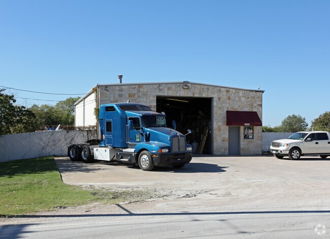
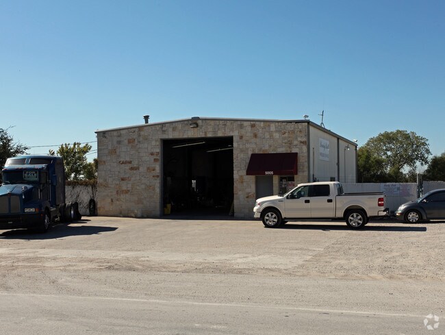
Property Record
5007 Dexham Rd, Rowlett, TX 75088
NEARBY LISTINGS FOR SALE OR LEASE
Property Detail
5007 Dexham Rd
Dallas-Fort Worth-Arlington, TX
Reason Crist
65022559010630100
REASON CRIST ABST 225 PG 590 TR 63.7 & BLK 1 LT 1 PERRY INDUST ACS 1.3062 INT 201400117078 DD05082014 CO-DC 0225590106307 2CW02255901
Commercialacreage
Dallas
X
Texas
48113C0240K
1
2024
0.09 AC
2025
NE Dallas/Garland
018133
Dallas/Ft Worth
DEMOGRAPHICS near 5007 Dexham Rd
1 Mile
3 Mile
5 Mile
2024 Total Population
6,174
78,658
251,835
2029 Population
6,094
77,964
252,492
Pop Growth 2024-2029
(1.30%)
(0.88%)
+ 0.26%
Average Age
38
38
38
2024 Total Households
2,079
24,841
83,041
HH Growth 2024-2029
(1.49%)
(1.04%)
+ 0.20%
Median Household Inc
$97,630
$76,583
$74,076
Avg Household Size
2.90
3.10
3.00
2024 Avg HH Vehicles
3.00
2.00
2.00
Median Home Value
$270,600
$245,459
$241,461
Median Year Built
1986
1985
1983
Nearby Places
Map Layers
Map Styles
 Street
 Aerial
- Restaurants
- Banks
- Shops
- Fitness
- Groceries
PUBLIC TRANSPORTATION
AIRPORT
Dallas Love Field
DRIVE
WALK
Distance
Dallas Love Field
37 min
23.9 mi
Dallas-Fort Worth International
DRIVE
WALK
Distance
Dallas-Fort Worth International
45 min
32.8 mi
Freight Ports
Port of Shreveport
DRIVE
WALK
Distance
Port of Shreveport
214 min
193.8 mi
SALE & LEASE HISTORY
LISTING DATE
SALE/LEASE

Nov 09, 2016
For Lease
Nearby Properties
Address
Land Use
TOTAL SIZE
Lot Size
Zoning
Address
Land Use
TOTAL SIZE
Lot Size
Zoning
261,164 SF
32.58 AC
Address
Land Use
TOTAL SIZE
Lot Size
Zoning
260,782 SF
16.30 AC
Z77
Address
Land Use
TOTAL SIZE
Lot Size
Zoning
228,458 SF
5.56 AC
Z236
Address
Land Use
TOTAL SIZE
Lot Size
Zoning
427,231 SF
9.96 AC
Z38
Address
Land Use
TOTAL SIZE
Lot Size
Zoning
313,217 SF
3.61 AC
Z205
Address
Land Use
TOTAL SIZE
Lot Size
Zoning
65,595 SF
19.22 AC
Z239
Address
Land Use
TOTAL SIZE
Lot Size
Zoning
178,125 SF
10.50 AC
Z77
Address
Land Use
TOTAL SIZE
Lot Size
Zoning
77,102 SF
27.47 AC
Z144
Address
Land Use
TOTAL SIZE
Lot Size
Zoning
60,593 SF
35.93 AC
Z06
Address
Land Use
TOTAL SIZE
Lot Size
Zoning
0.12 AC
Z63
Address
Land Use
TOTAL SIZE
Lot Size
Zoning
43,600 SF
62.86 AC
Z306
Address
Land Use
TOTAL SIZE
Lot Size
Zoning
138,865 SF
11.38 AC
Z239
Address
Land Use
TOTAL SIZE
Lot Size
Zoning
420,500 SF
33.25 AC
Address
Land Use
TOTAL SIZE
Lot Size
Zoning
133,249 SF
9.71 AC
Z239
Address
Land Use
TOTAL SIZE
Lot Size
Zoning
65,917 SF
7.99 AC
Z239
Address
Land Use
TOTAL SIZE
Lot Size
Zoning
261,000 SF
1 AC
Z318
Address
Land Use
TOTAL SIZE
Lot Size
Zoning
145,203 SF
12.86 AC
Z239
Address
Land Use
TOTAL SIZE
Lot Size
Zoning
119,397 SF
7.41 AC
Z160
Address
Land Use
TOTAL SIZE
Lot Size
Zoning
76,812 SF
9.22 AC
Z144
Address
Land Use
TOTAL SIZE
Lot Size
Zoning
226,800 SF
4.98 AC
Z340
Address
Land Use
TOTAL SIZE
Lot Size
Zoning
82,847 SF
4.87 AC
Z236
Address
Land Use
TOTAL SIZE
Lot Size
Zoning
78,017 SF
1.75 AC
Z236
Address
Land Use
TOTAL SIZE
Lot Size
Zoning
83,154 SF
14.39 AC
Z386
Address
Land Use
TOTAL SIZE
Lot Size
Zoning
58,217 SF
7.09 AC
Z390
Address
Land Use
TOTAL SIZE
Lot Size
Zoning
140,000 SF
12.76 AC
Address
Land Use
TOTAL SIZE
Lot Size
Zoning
141,200 SF
10.81 AC
Address
Land Use
TOTAL SIZE
Lot Size
Zoning
150,926 SF
9.33 AC
Address
Land Use
TOTAL SIZE
Lot Size
Zoning
32,228 SF
11.13 AC
Z239
Address
Land Use
TOTAL SIZE
Lot Size
Zoning
0.02 AC
Z236
Address
Land Use
TOTAL SIZE
Lot Size
Zoning
203,983 SF
31.19 AC
Z92
The World's #1 Commercial Real Estate Marketplace
Connect with us
© 2026 CoStar Group
The information above has been obtained from sources believed reliable. While we do not doubt its accuracy we have not verified it and make no guarantee, warranty or representation about it. It is your responsibility to independently confirm its accuracy and completeness. Any projections, opinions, assumptions, or estimates used are for example only and do not represent the current or future performance of the property. The value of this transaction to you depends on tax and other factors which should be evaluated by your tax, financial, and legal advisors. You and your advisors should conduct a careful, independent investigation of the property to determine to your satisfaction the suitability of the property for your needs.