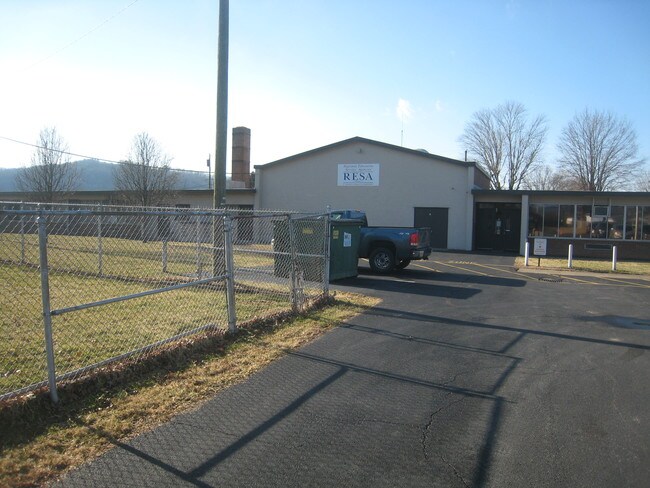
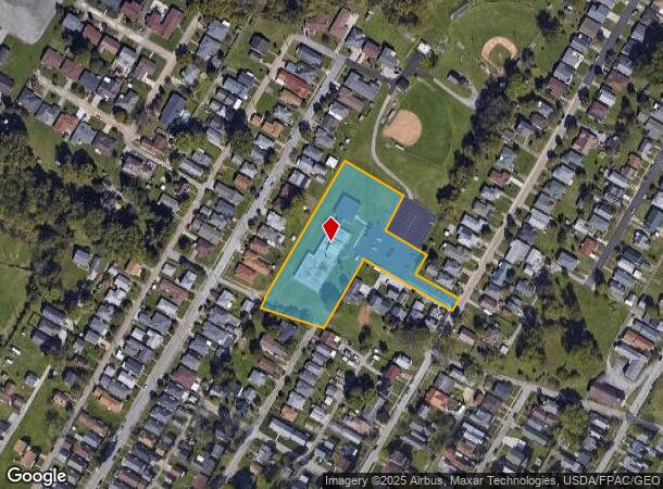
Property Record
501 22Nd St, Dunbar, WV 25064
NEARBY LISTINGS FOR SALE OR LEASE
Property Detail
501 22Nd St
26-6-00560002
2-428/1000A PT MITCHELL PROP N S FLETCHER AVE
Publicschool
Kanawha
X
West Virginia
54039C0401E
2.43 AC
0
Outlying Kanawha County
2025
Charleston WV
010300
Charleston, WV
DEMOGRAPHICS near 501 22Nd St
1 Mile
3 Mile
5 Mile
2024 Total Population
6,349
23,291
62,017
2029 Population
6,167
22,538
60,007
Pop Growth 2024-2029
(2.87%)
(3.23%)
(3.24%)
Average Age
43
43
42
2024 Total Households
2,901
10,610
27,131
HH Growth 2024-2029
(3.00%)
(3.43%)
(3.35%)
Median Household Inc
$54,458
$49,914
$57,949
Avg Household Size
2.10
2.10
2.20
2024 Avg HH Vehicles
1.00
2.00
2.00
Median Home Value
$115,655
$121,263
$143,359
Median Year Built
1957
1959
1963
Nearby Places
Map Layers
Map Styles
 Street
 Aerial
- Restaurants
- Banks
- Shops
- Fitness
- Groceries
PUBLIC TRANSPORTATION
COMMUTER RAIL
Charleston (Cardinal - Amtrak)
DRIVE
WALK
Distance
Charleston (Cardinal - Amtrak)
12 min
7.6 mi
AIRPORT
West Virginia International Yeager
DRIVE
WALK
Distance
West Virginia International Yeager
23 min
13.1 mi
Freight Ports
Virginia Port Authority - Richmond
DRIVE
WALK
Distance
Virginia Port Authority - Richmond
373 min
330.4 mi
SALE & LEASE HISTORY
LISTING DATE
SALE/LEASE

Mar 07, 2018
For Sale
Nearby Properties
Address
Land Use
TOTAL SIZE
Lot Size
Zoning
Address
Land Use
TOTAL SIZE
Lot Size
Zoning
Address
Land Use
TOTAL SIZE
Lot Size
Zoning
Address
Land Use
TOTAL SIZE
Lot Size
Zoning
Address
Land Use
TOTAL SIZE
Lot Size
Zoning
321.11 AC
Address
Land Use
TOTAL SIZE
Lot Size
Zoning
Address
Land Use
TOTAL SIZE
Lot Size
Zoning
Address
Land Use
TOTAL SIZE
Lot Size
Zoning
Address
Land Use
TOTAL SIZE
Lot Size
Zoning
36.96 AC
Address
Land Use
TOTAL SIZE
Lot Size
Zoning
Address
Land Use
TOTAL SIZE
Lot Size
Zoning
110.36 AC
Address
Land Use
TOTAL SIZE
Lot Size
Zoning
Address
Land Use
TOTAL SIZE
Lot Size
Zoning
Address
Land Use
TOTAL SIZE
Lot Size
Zoning
Address
Land Use
TOTAL SIZE
Lot Size
Zoning
Address
Land Use
TOTAL SIZE
Lot Size
Zoning
41.92 AC
Address
Land Use
TOTAL SIZE
Lot Size
Zoning
13.67 AC
Address
Land Use
TOTAL SIZE
Lot Size
Zoning
Address
Land Use
TOTAL SIZE
Lot Size
Zoning
Address
Land Use
TOTAL SIZE
Lot Size
Zoning
Address
Land Use
TOTAL SIZE
Lot Size
Zoning
15.50 AC
Address
Land Use
TOTAL SIZE
Lot Size
Zoning
Address
Land Use
TOTAL SIZE
Lot Size
Zoning
Address
Land Use
TOTAL SIZE
Lot Size
Zoning
Address
Land Use
TOTAL SIZE
Lot Size
Zoning
Address
Land Use
TOTAL SIZE
Lot Size
Zoning
16.42 AC
Address
Land Use
TOTAL SIZE
Lot Size
Zoning
Address
Land Use
TOTAL SIZE
Lot Size
Zoning
1.28 AC
Address
Land Use
TOTAL SIZE
Lot Size
Zoning
Address
Land Use
TOTAL SIZE
Lot Size
Zoning
311.78 AC
Address
Land Use
TOTAL SIZE
Lot Size
Zoning
7.08 AC
The World's #1 Commercial Real Estate Marketplace
Connect with us
© 2025 CoStar Group
The information above has been obtained from sources believed reliable. While we do not doubt its accuracy we have not verified it and make no guarantee, warranty or representation about it. It is your responsibility to independently confirm its accuracy and completeness. Any projections, opinions, assumptions, or estimates used are for example only and do not represent the current or future performance of the property. The value of this transaction to you depends on tax and other factors which should be evaluated by your tax, financial, and legal advisors. You and your advisors should conduct a careful, independent investigation of the property to determine to your satisfaction the suitability of the property for your needs.