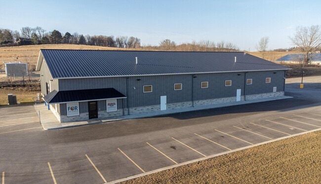
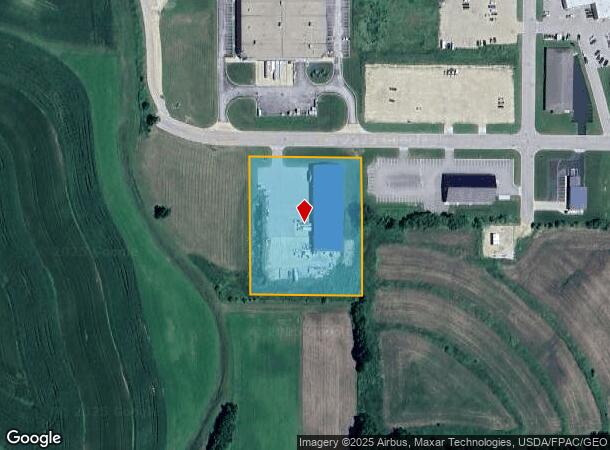
Property Record
501 22Nd St, Zumbrota, MN 55992
NEARBY LISTINGS FOR SALE OR LEASE
-
-
View all Zumbrota listings for lease on LoopNet.com
Property Detail
501 22Nd St
Other Market Areas
Highway 52 Sw Bus Park 1St Add
Red Wing, MN
HIGHWAY 52 SW BUS PARK 1ST ADD 2.82 AC DOC#655876 PT OF LOT 1 BLK 2 LYING E OF FOLL DESC LINE: COM AT SE COR LOT 1, W ALNG S
72.395.0031
Goodhue
Heavymanufacturing
Minnesota
2025
1
2025
2.82 AC
080800
Minnesota South Area
19,200 SF
DEMOGRAPHICS near 501 22Nd St
1 Mile
3 Mile
5 Mile
2024 Total Population
2,472
4,781
5,445
2029 Population
2,521
4,890
5,555
Pop Growth 2024-2029
+ 1.98%
+ 2.28%
+ 2.02%
Average Age
41
41
41
2024 Total Households
988
1,908
2,148
HH Growth 2024-2029
+ 1.92%
+ 2.20%
+ 2.00%
Median Household Inc
$72,156
$73,777
$76,850
Avg Household Size
2.50
2.50
2.50
2024 Avg HH Vehicles
2.00
2.00
2.00
Median Home Value
$237,540
$238,614
$247,214
Median Year Built
1969
1970
1970
Nearby Places
Map Layers
Map Styles
 Street
 Aerial
- Restaurants
- Banks
- Shops
- Fitness
- Groceries
PUBLIC TRANSPORTATION
AIRPORT
Rochester International
DRIVE
WALK
Distance
Rochester International
40 min
31.1 mi
SALE & LEASE HISTORY
LISTING DATE
SALE/LEASE

Mar 12, 2024
For Lease
Mar 12, 2024
For Sale
Nearby Properties
Address
Land Use
TOTAL SIZE
Lot Size
Zoning
Address
Land Use
TOTAL SIZE
Lot Size
Zoning
236,199 SF
17.67 AC
Address
Land Use
TOTAL SIZE
Lot Size
Zoning
54,694 SF
1.33 AC
Address
Land Use
TOTAL SIZE
Lot Size
Zoning
72,424 SF
0.23 AC
Address
Land Use
TOTAL SIZE
Lot Size
Zoning
81,661 SF
8.30 AC
Address
Land Use
TOTAL SIZE
Lot Size
Zoning
13,550 SF
3.62 AC
Address
Land Use
TOTAL SIZE
Lot Size
Zoning
22,272 SF
6.66 AC
Address
Land Use
TOTAL SIZE
Lot Size
Zoning
59,214 SF
7.56 AC
Address
Land Use
TOTAL SIZE
Lot Size
Zoning
7,365 SF
2.16 AC
Address
Land Use
TOTAL SIZE
Lot Size
Zoning
22,953 SF
4.19 AC
Address
Land Use
TOTAL SIZE
Lot Size
Zoning
44,010 SF
0.66 AC
Address
Land Use
TOTAL SIZE
Lot Size
Zoning
222 AC
Address
Land Use
TOTAL SIZE
Lot Size
Zoning
3,120 SF
11.73 AC
Address
Land Use
TOTAL SIZE
Lot Size
Zoning
208.14 AC
Address
Land Use
TOTAL SIZE
Lot Size
Zoning
143,232 SF
56.21 AC
Address
Land Use
TOTAL SIZE
Lot Size
Zoning
79,848 SF
0.58 AC
Address
Land Use
TOTAL SIZE
Lot Size
Zoning
Address
Land Use
TOTAL SIZE
Lot Size
Zoning
22.11 AC
Address
Land Use
TOTAL SIZE
Lot Size
Zoning
25,446 SF
20 AC
Address
Land Use
TOTAL SIZE
Lot Size
Zoning
152.85 AC
Address
Land Use
TOTAL SIZE
Lot Size
Zoning
19,352 SF
0.34 AC
Address
Land Use
TOTAL SIZE
Lot Size
Zoning
150.26 AC
Address
Land Use
TOTAL SIZE
Lot Size
Zoning
25,615 SF
2.19 AC
Address
Land Use
TOTAL SIZE
Lot Size
Zoning
10,726 SF
2.83 AC
Address
Land Use
TOTAL SIZE
Lot Size
Zoning
Address
Land Use
TOTAL SIZE
Lot Size
Zoning
9,513 SF
0.71 AC
The World's #1 Commercial Real Estate Marketplace
Connect with us
© 2026 CoStar Group
The information above has been obtained from sources believed reliable. While we do not doubt its accuracy we have not verified it and make no guarantee, warranty or representation about it. It is your responsibility to independently confirm its accuracy and completeness. Any projections, opinions, assumptions, or estimates used are for example only and do not represent the current or future performance of the property. The value of this transaction to you depends on tax and other factors which should be evaluated by your tax, financial, and legal advisors. You and your advisors should conduct a careful, independent investigation of the property to determine to your satisfaction the suitability of the property for your needs.