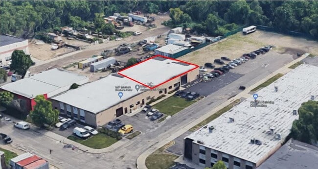
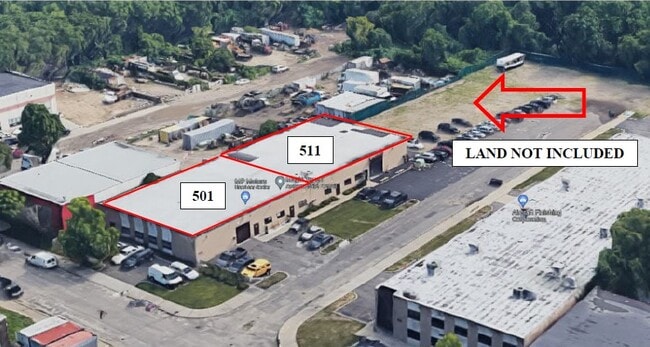
Property Record
501 Sheffield Ave, West Babylon, NY 11704
Current Lease Availabilities
NEARBY LISTINGS FOR SALE OR LEASE
Property Detail
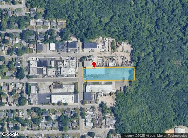
501 Sheffield Ave
Nassau County-Suffolk County, NY
Belmont Terrace
0100-145-00-05-00-018-002
FM 183 SEC B BL 11 LTS 12-40 EVEN LTS 1-5 & 41-45 & P/O RD BED
Industrialgeneral
Suffolk
A
New York
36103C0855H
18
2024
1.40 AC
2024
Southwest Suffolk
123002
Long Island (New York)
12,600 SF
DEMOGRAPHICS near 501 Sheffield Ave
1 Mile
3 Mile
5 Mile
2024 Total Population
16,188
140,023
270,492
2029 Population
15,802
136,928
264,313
Pop Growth 2024-2029
(2.38%)
(2.21%)
(2.28%)
Average Age
41
41
40
2024 Total Households
5,459
45,572
86,380
HH Growth 2024-2029
(2.64%)
(2.44%)
(2.46%)
Median Household Inc
$114,161
$116,260
$112,868
Avg Household Size
2.90
2.90
3.00
2024 Avg HH Vehicles
2.00
2.00
2.00
Median Home Value
$446,524
$457,839
$456,870
Median Year Built
1963
1960
1962
Nearby Places
Map Layers
Map Styles
 Street
 Aerial
- Restaurants
- Banks
- Shops
- Fitness
- Groceries
PUBLIC TRANSPORTATION
COMMUTER RAIL
Babylon Station (Babylon Branch - Long Island Rail Road, Montauk Branch - Long Island Rail Road)
DRIVE
WALK
Distance
Babylon Station (Babylon Branch - Long Island Rail Road, Montauk Branch - Long Island Rail Road)
10 min
2.1 mi
Wyandanch Station (Ronkonkoma Branch - Long Island Rail Road)
DRIVE
WALK
Distance
Wyandanch Station (Ronkonkoma Branch - Long Island Rail Road)
13 min
3.7 mi
AIRPORT
Long Island MacArthur
DRIVE
WALK
Distance
Long Island MacArthur
26 min
16.7 mi
John F Kennedy International
DRIVE
WALK
Distance
John F Kennedy International
39 min
29.9 mi
LaGuardia
DRIVE
WALK
Distance
LaGuardia
50 min
37.3 mi
Nearby Properties
Address
Land Use
TOTAL SIZE
Lot Size
Zoning
Address
Land Use
TOTAL SIZE
Lot Size
Zoning
48.97 AC
GSC
Address
Land Use
TOTAL SIZE
Lot Size
Zoning
256 SF
24.20 AC
GSC
Address
Land Use
TOTAL SIZE
Lot Size
Zoning
20 AC
A
Address
Land Use
TOTAL SIZE
Lot Size
Zoning
1,400 SF
10.27 AC
BD
Address
Land Use
TOTAL SIZE
Lot Size
Zoning
20.50 AC
B
Address
Land Use
TOTAL SIZE
Lot Size
Zoning
15 AC
A
Address
Land Use
TOTAL SIZE
Lot Size
Zoning
4,290 SF
1.50 AC
VILLA
Address
Land Use
TOTAL SIZE
Lot Size
Zoning
18.70 AC
A
Address
Land Use
TOTAL SIZE
Lot Size
Zoning
6.66 AC
A
Address
Land Use
TOTAL SIZE
Lot Size
Zoning
10.22 AC
IBD
Address
Land Use
TOTAL SIZE
Lot Size
Zoning
14.60 AC
A
Address
Land Use
TOTAL SIZE
Lot Size
Zoning
13.30 AC
A
Address
Land Use
TOTAL SIZE
Lot Size
Zoning
9.70 AC
B
Address
Land Use
TOTAL SIZE
Lot Size
Zoning
19.40 AC
IND1
Address
Land Use
TOTAL SIZE
Lot Size
Zoning
11 AC
B
Address
Land Use
TOTAL SIZE
Lot Size
Zoning
7.50 AC
B
Address
Land Use
TOTAL SIZE
Lot Size
Zoning
6.37 AC
BUS1
Address
Land Use
TOTAL SIZE
Lot Size
Zoning
6.37 AC
BUS3
Address
Land Use
TOTAL SIZE
Lot Size
Zoning
1.82 AC
Address
Land Use
TOTAL SIZE
Lot Size
Zoning
1.85 AC
BUS3
Address
Land Use
TOTAL SIZE
Lot Size
Zoning
3.60 AC
BUS1
Address
Land Use
TOTAL SIZE
Lot Size
Zoning
2.40 AC
A
Address
Land Use
TOTAL SIZE
Lot Size
Zoning
14.40 AC
NULL
Address
Land Use
TOTAL SIZE
Lot Size
Zoning
3.04 AC
BUS1
Address
Land Use
TOTAL SIZE
Lot Size
Zoning
3.91 AC
IND1
Address
Land Use
TOTAL SIZE
Lot Size
Zoning
4.06 AC
BUS1
Address
Land Use
TOTAL SIZE
Lot Size
Zoning
5,010 SF
0.30 AC
R10
Address
Land Use
TOTAL SIZE
Lot Size
Zoning
3.01 AC
BUS1
Address
Land Use
TOTAL SIZE
Lot Size
Zoning
400 AC
A
Address
Land Use
TOTAL SIZE
Lot Size
Zoning
2.69 AC
BUS1
The World's #1 Commercial Real Estate Marketplace
Connect with us
© 2026 CoStar Group
The information above has been obtained from sources believed reliable. While we do not doubt its accuracy we have not verified it and make no guarantee, warranty or representation about it. It is your responsibility to independently confirm its accuracy and completeness. Any projections, opinions, assumptions, or estimates used are for example only and do not represent the current or future performance of the property. The value of this transaction to you depends on tax and other factors which should be evaluated by your tax, financial, and legal advisors. You and your advisors should conduct a careful, independent investigation of the property to determine to your satisfaction the suitability of the property for your needs.