Property Record
501 Old Mill Rd, Rocky Mount, NC 27804


Property Detail
501 Old Mill Rd
3840-15-53-9210
105 1 20, 1.58 AC, LT 1, REJECTED STONE AC, 1C, LT 1, REJECTED STONE
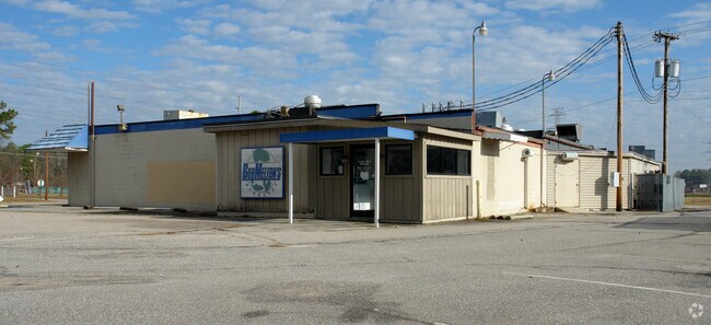
Restaurantbuilding
Nash
B2
North Carolina
B and X Area of moderate flood hazard, usually the area between the limits of the 100-year and 500-year floods.
1.58 AC
2025
Rocky Mount/Wilson
2025
Other Market Areas
010506
Rocky Mount, NC
5,940 SF
NEARBY LISTINGS FOR SALE OR LEASE
-
-
-
-
-
-
-
-
-
-
-
No Photo
-
View all Rocky Mount listings for sale on LoopNet.com
DEMOGRAPHICS near 501 Old Mill Rd
1 mile
3 mile
5 mile
2025 Total Population
3,269
38,610
62,385
2030 Population
3,331
40,257
64,545
Pop Growth 2025-2030
+ 1.90%
+ 4.27%
+ 3.46%
Average Age
44
42
41
2025 Total Households
1,422
16,887
26,509
HH Growth 2025-2030
+ 1.97%
+ 4.33%
+ 3.55%
Median Household Inc
$71,718
$54,209
$56,700
Avg Household Size
2.20
2.20
2.30
2025 Avg HH Vehicles
2.00
2.00
2.00
Median Home Value
$180,785
$183,965
$183,799
Median Year Built
1970
1979
1980
Nearby Places
Map Layers
Map Styles
 Street
 Aerial
Transit
 Traffic
 Biking
Places
Listings with unknown addresses are not visible on the map
- Restaurants
- Banks
- Shops
- Fitness
- Groceries
PUBLIC TRANSPORTATION
COMMUTER RAIL
Drive
Walk
Distance
6 min
2.7 mi
AIRPORT
Pitt-Greenville
Drive
Walk
Distance
Pitt-Greenville
55 min
44.4 mi
Nearby Properties
Address
Land Use
TOTAL SIZE
Lot Size
Zoning
Address
Land Use
TOTAL SIZE
Lot Size
Zoning
133,154 SF
70.45 AC
MA
Address
Land Use
TOTAL SIZE
Lot Size
Zoning
129,595 SF
11.35 AC
B2CU
Address
Land Use
TOTAL SIZE
Lot Size
Zoning
130,639 SF
60.52 AC
A1M
Address
Land Use
TOTAL SIZE
Lot Size
Zoning
104,995 SF
16.01 AC
Address
Land Use
TOTAL SIZE
Lot Size
Zoning
10,632 SF
16.61 AC
R6
Address
Land Use
TOTAL SIZE
Lot Size
Zoning
78,052 SF
122.10 AC
I2
Address
Land Use
TOTAL SIZE
Lot Size
Zoning
79,027 SF
33.37 AC
R10
Address
Land Use
TOTAL SIZE
Lot Size
Zoning
98,831 SF
5.40 AC
I
Address
Land Use
TOTAL SIZE
Lot Size
Zoning
165,000 SF
4.66 AC
Address
Land Use
TOTAL SIZE
Lot Size
Zoning
29,504 SF
18.61 AC
Address
Land Use
TOTAL SIZE
Lot Size
Zoning
6,976 SF
15.97 AC
R6
Address
Land Use
TOTAL SIZE
Lot Size
Zoning
8,216 SF
4.21 AC
B4
Address
Land Use
TOTAL SIZE
Lot Size
Zoning
65,826 SF
16.77 AC
Address
Land Use
TOTAL SIZE
Lot Size
Zoning
204,903 SF
23.07 AC
Address
Land Use
TOTAL SIZE
Lot Size
Zoning
85,766 SF
4.61 AC
B5
Address
Land Use
TOTAL SIZE
Lot Size
Zoning
98,065 SF
6.14 AC
I
Address
Land Use
TOTAL SIZE
Lot Size
Zoning
73,338 SF
2.81 AC
B5CU
Address
Land Use
TOTAL SIZE
Lot Size
Zoning
16,110 SF
17.49 AC
MA
Address
Land Use
TOTAL SIZE
Lot Size
Zoning
32,051 SF
18.50 AC
R6
Address
Land Use
TOTAL SIZE
Lot Size
Zoning
15,650 SF
32.25 AC
R10
Address
Land Use
TOTAL SIZE
Lot Size
Zoning
59,236 SF
2.18 AC
B5M
Address
Land Use
TOTAL SIZE
Lot Size
Zoning
51,543 SF
9.61 AC
I
Address
Land Use
TOTAL SIZE
Lot Size
Zoning
47,968 SF
4.68 AC
I
Address
Land Use
TOTAL SIZE
Lot Size
Zoning
118,800 SF
5.51 AC
I
Address
Land Use
TOTAL SIZE
Lot Size
Zoning
6,253 SF
16.22 AC
A1
Address
Land Use
TOTAL SIZE
Lot Size
Zoning
135,400 SF
21.45 AC
B2
Address
Land Use
TOTAL SIZE
Lot Size
Zoning
25,936 SF
22.35 AC
R15
Address
Land Use
TOTAL SIZE
Lot Size
Zoning
62,024 SF
5.39 AC
B5
Address
Land Use
TOTAL SIZE
Lot Size
Zoning
7,022 SF
14.89 AC
A1
Address
Land Use
TOTAL SIZE
Lot Size
Zoning
47,410 SF
2.58 AC
B5CU
The World's #1 Commercial Real Estate Marketplace
Connect with us
© 2026 CoStar Group
The information above has been obtained from sources believed reliable. While we do not doubt its accuracy we have not verified it and make no guarantee, warranty or representation about it. It is your responsibility to independently confirm its accuracy and completeness. Any projections, opinions, assumptions, or estimates used are for example only and do not represent the current or future performance of the property. The value of this transaction to you depends on tax and other factors which should be evaluated by your tax, financial, and legal advisors. You and your advisors should conduct a careful, independent investigation of the property to determine to your satisfaction the suitability of the property for your needs.