Property Record
501 Andrews Hwy, Midland, TX 79701
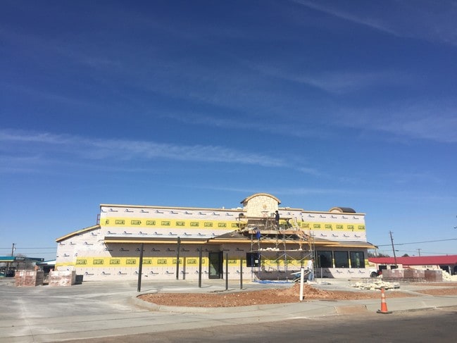

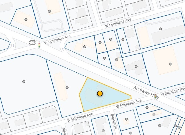
Property Detail
501 Andrews Hwy
Midland, TX
ACRES: 0.788 BLK: 011 LOT: 001 ADDN: THE GARDENS ADDN SEC 7
R000020-395
Midland
Officebuilding
Texas
LR2
1
2025
0.79 AC
2025
Midland & Odessa
000500
Other Market Areas
3,078 SF
NEARBY LISTINGS FOR SALE OR LEASE
DEMOGRAPHICS near 501 Andrews Hwy
1 mile
3 mile
5 mile
2025 Total Population
10,352
91,438
147,508
2030 Population
11,222
100,389
162,755
Pop Growth 2025-2030
+ 8.40%
+ 9.79%
+ 10.34%
Average Age
36
36
35
2025 Total Households
3,789
33,614
54,099
HH Growth 2025-2030
+ 9.63%
+ 11.04%
+ 11.56%
Median Household Inc
$86,933
$78,451
$89,254
Avg Household Size
2.60
2.60
2.70
2025 Avg HH Vehicles
2.00
2.00
2.00
Median Home Value
$243,137
$267,896
$309,116
Median Year Built
1957
1975
1985
Nearby Places
Map Layers
Map Styles
 Street
 Aerial
Transit
 Traffic
 Biking
Places
Listings with unknown addresses are not visible on the map
- Restaurants
- Banks
- Shops
- Fitness
- Groceries
PUBLIC TRANSPORTATION
AIRPORT
Midland International Air And Space Port
Drive
Walk
Distance
Midland International Air And Space Port
16 min
9.9 mi
Nearby Properties
Address
Land Use
TOTAL SIZE
Lot Size
Zoning
Address
Land Use
TOTAL SIZE
Lot Size
Zoning
56,157 SF
18.19 AC
PDOC
Address
Land Use
TOTAL SIZE
Lot Size
Zoning
15,052 SF
4.68 AC
C1
Address
Land Use
TOTAL SIZE
Lot Size
Zoning
94,059 SF
15.95 AC
PDMX
Address
Land Use
TOTAL SIZE
Lot Size
Zoning
37,220 SF
7.95 AC
O2
Address
Land Use
TOTAL SIZE
Lot Size
Zoning
2,453 SF
13.68 AC
Address
Land Use
TOTAL SIZE
Lot Size
Zoning
1,173 SF
14.05 AC
PDHD
Address
Land Use
TOTAL SIZE
Lot Size
Zoning
7,793 SF
15.51 AC
Address
Land Use
TOTAL SIZE
Lot Size
Zoning
29,645 SF
2.07 AC
C1
Address
Land Use
TOTAL SIZE
Lot Size
Zoning
249,810 SF
9.42 AC
Address
Land Use
TOTAL SIZE
Lot Size
Zoning
10,228 SF
15.98 AC
Address
Land Use
TOTAL SIZE
Lot Size
Zoning
28,750 SF
10.11 AC
Address
Land Use
TOTAL SIZE
Lot Size
Zoning
8,004 SF
3.58 AC
C1
Address
Land Use
TOTAL SIZE
Lot Size
Zoning
15,000 SF
39.46 AC
PDHD
Address
Land Use
TOTAL SIZE
Lot Size
Zoning
12,916 SF
0.71 AC
MF1
Address
Land Use
TOTAL SIZE
Lot Size
Zoning
44,784 SF
11.97 AC
MF1
Address
Land Use
TOTAL SIZE
Lot Size
Zoning
133,056 SF
2.07 AC
C1
Address
Land Use
TOTAL SIZE
Lot Size
Zoning
7,526 SF
12 AC
MF1
Address
Land Use
TOTAL SIZE
Lot Size
Zoning
46,010 SF
13.02 AC
PDOC
Address
Land Use
TOTAL SIZE
Lot Size
Zoning
12,960 SF
15.93 AC
MF1
Address
Land Use
TOTAL SIZE
Lot Size
Zoning
2,049 SF
8.79 AC
MF1
Address
Land Use
TOTAL SIZE
Lot Size
Zoning
7,200 SF
2.07 AC
C1
Address
Land Use
TOTAL SIZE
Lot Size
Zoning
46,512 SF
0.96 AC
C1
Address
Land Use
TOTAL SIZE
Lot Size
Zoning
5,884 SF
22.97 AC
PDSC
Address
Land Use
TOTAL SIZE
Lot Size
Zoning
209,680 SF
6.16 AC
Address
Land Use
TOTAL SIZE
Lot Size
Zoning
96,390 SF
0.96 AC
C1
Address
Land Use
TOTAL SIZE
Lot Size
Zoning
7,008 SF
0.96 AC
C1
Address
Land Use
TOTAL SIZE
Lot Size
Zoning
1,678 SF
9.11 AC
MF1
Address
Land Use
TOTAL SIZE
Lot Size
Zoning
41,790 SF
1.50 AC
C1
Address
Land Use
TOTAL SIZE
Lot Size
Zoning
5,600 SF
10.18 AC
PDMX
Address
Land Use
TOTAL SIZE
Lot Size
Zoning
12.91 AC
The World's #1 Commercial Real Estate Marketplace
Connect with us
© 2026 CoStar Group
The information above has been obtained from sources believed reliable. While we do not doubt its accuracy we have not verified it and make no guarantee, warranty or representation about it. It is your responsibility to independently confirm its accuracy and completeness. Any projections, opinions, assumptions, or estimates used are for example only and do not represent the current or future performance of the property. The value of this transaction to you depends on tax and other factors which should be evaluated by your tax, financial, and legal advisors. You and your advisors should conduct a careful, independent investigation of the property to determine to your satisfaction the suitability of the property for your needs.