Property Record
501 County Road 405, Taylor, TX 76574
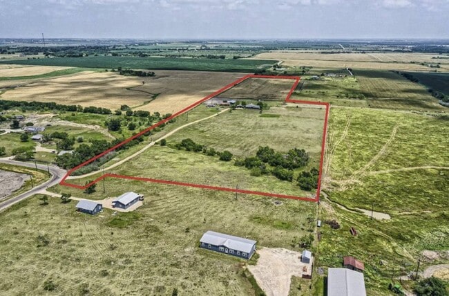


Property Detail
501 County Road 405
R018586
AW0924 - AVERY, W. SUR., SERIAL # CHIAL2440A, TITLE # CN, LABEL # TRA0390109, ACRES 20.573, MODEL CROWN HOUSING
Farms
Williamson
B and X Area of moderate flood hazard, usually the area between the limits of the 100-year and 500-year floods.
Texas
2024
20.57 AC
2025
Round Rock
020808
Austin
2,655 SF
Austin-Round Rock-San Marcos, TX
NEARBY LISTINGS FOR SALE OR LEASE
DEMOGRAPHICS near 501 County Road 405
1 mile
3 mile
5 mile
2025 Total Population
158
3,398
19,872
2030 Population
185
3,932
22,776
Pop Growth 2025-2030
+ 17.09%
+ 15.72%
+ 14.61%
Average Age
43
40
40
2025 Total Households
64
1,169
7,442
HH Growth 2025-2030
+ 17.19%
+ 16.51%
+ 15.09%
Median Household Inc
$81,250
$70,593
$72,206
Avg Household Size
2.40
2.60
2.60
2025 Avg HH Vehicles
3.00
2.00
2.00
Median Home Value
$376,086
$408,733
$333,357
Median Year Built
2006
1999
1984
Nearby Places
Map Layers
Map Styles
 Street
 Aerial
Layers
 Traffic
 Biking
Places
Listings with unknown addresses are not visible on the map
- Restaurants
- Banks
- Shops
- Fitness
- Groceries
PUBLIC TRANSPORTATION
COMMUTER RAIL
Drive
Walk
Distance
11 min
4.0 mi
AIRPORT
Austin-Bergstrom International
Drive
Walk
Distance
Austin-Bergstrom International
58 min
35.3 mi
SALE & LEASE HISTORY
LISTING DATE
SALE/LEASE

Jun 16, 2023
For Sale
Nearby Properties
Address
Land Use
TOTAL SIZE
Lot Size
Zoning
Address
Land Use
TOTAL SIZE
Lot Size
Zoning
5,242,769 SF
346.61 AC
Address
Land Use
TOTAL SIZE
Lot Size
Zoning
1,213.97 AC
Address
Land Use
TOTAL SIZE
Lot Size
Zoning
52,527 SF
1,213.97 AC
Address
Land Use
TOTAL SIZE
Lot Size
Zoning
46.70 AC
Address
Land Use
TOTAL SIZE
Lot Size
Zoning
859.64 AC
Address
Land Use
TOTAL SIZE
Lot Size
Zoning
133,666 SF
64.51 AC
2-M1
Address
Land Use
TOTAL SIZE
Lot Size
Zoning
35.12 AC
Address
Land Use
TOTAL SIZE
Lot Size
Zoning
64,600 SF
27.98 AC
Address
Land Use
TOTAL SIZE
Lot Size
Zoning
40,000 SF
7 AC
Address
Land Use
TOTAL SIZE
Lot Size
Zoning
50,050 SF
5.42 AC
Address
Land Use
TOTAL SIZE
Lot Size
Zoning
29,694 SF
5.64 AC
Address
Land Use
TOTAL SIZE
Lot Size
Zoning
116,792 SF
5.97 AC
2-M1
Address
Land Use
TOTAL SIZE
Lot Size
Zoning
112,500 SF
6.07 AC
Address
Land Use
TOTAL SIZE
Lot Size
Zoning
66.43 AC
Address
Land Use
TOTAL SIZE
Lot Size
Zoning
4,266 SF
2.96 AC
0-M2
Address
Land Use
TOTAL SIZE
Lot Size
Zoning
4,826 SF
5.36 AC
Address
Land Use
TOTAL SIZE
Lot Size
Zoning
11,832 SF
11.25 AC
Address
Land Use
TOTAL SIZE
Lot Size
Zoning
36.84 AC
Address
Land Use
TOTAL SIZE
Lot Size
Zoning
96.34 AC
Address
Land Use
TOTAL SIZE
Lot Size
Zoning
26,712 SF
2.89 AC
Address
Land Use
TOTAL SIZE
Lot Size
Zoning
15.20 AC
Address
Land Use
TOTAL SIZE
Lot Size
Zoning
12,180 SF
5 AC
Address
Land Use
TOTAL SIZE
Lot Size
Zoning
252 SF
4.62 AC
Address
Land Use
TOTAL SIZE
Lot Size
Zoning
13,458 SF
6.52 AC
Address
Land Use
TOTAL SIZE
Lot Size
Zoning
7,137 SF
5.60 AC
Address
Land Use
TOTAL SIZE
Lot Size
Zoning
1.36 AC
2-M1
Address
Land Use
TOTAL SIZE
Lot Size
Zoning
20.88 AC
Address
Land Use
TOTAL SIZE
Lot Size
Zoning
28,800 SF
1.31 AC
2-M1
Address
Land Use
TOTAL SIZE
Lot Size
Zoning
5,868 SF
1.70 AC
0-M2
Address
Land Use
TOTAL SIZE
Lot Size
Zoning
70 SF
8.20 AC
The World's #1 Commercial Real Estate Marketplace
Connect with us
© 2026 CoStar Group
The information above has been obtained from sources believed reliable. While we do not doubt its accuracy we have not verified it and make no guarantee, warranty or representation about it. It is your responsibility to independently confirm its accuracy and completeness. Any projections, opinions, assumptions, or estimates used are for example only and do not represent the current or future performance of the property. The value of this transaction to you depends on tax and other factors which should be evaluated by your tax, financial, and legal advisors. You and your advisors should conduct a careful, independent investigation of the property to determine to your satisfaction the suitability of the property for your needs.