Property Record
501 E Main St, Parma, ID 83660
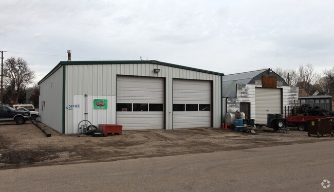
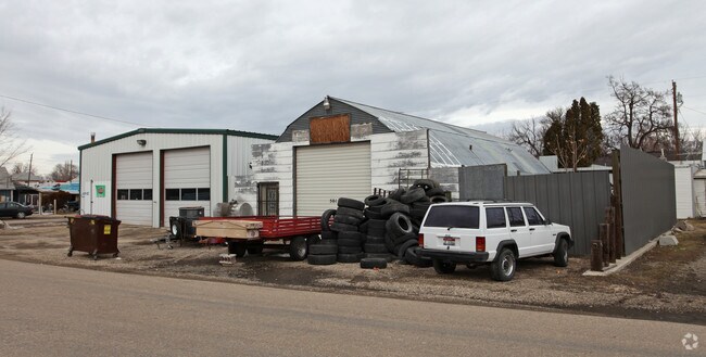
Property Detail
501 E Main St
Boise City, ID
09-5N-5W SW PARMA ORIGINAL SW 1/2 OF LT 11 BLK 30
1938200000
CANYON
Industrialgeneral
Idaho
B and X Area of moderate flood hazard, usually the area between the limits of the 100-year and 500-year floods.
11
2024
0.08 AC
2025
North Canyon County
022100
Boise City/Nampa
NEARBY LISTINGS FOR SALE OR LEASE
-
-
View all Parma listings for sale on LoopNet.com
DEMOGRAPHICS near 501 E Main St
1 mile
3 mile
5 mile
2024 Total Population
2,402
3,497
5,504
2029 Population
2,632
3,853
6,079
Pop Growth 2024-2029
+ 9.58%
+ 10.18%
+ 10.45%
Average Age
39
40
40
2024 Total Households
821
1,195
1,880
HH Growth 2024-2029
+ 9.99%
+ 10.54%
+ 10.80%
Median Household Inc
$50,139
$54,734
$59,514
Avg Household Size
2.90
2.90
2.90
2024 Avg HH Vehicles
2.00
2.00
2.00
Median Home Value
$329,714
$361,087
$391,642
Median Year Built
1975
1977
1980
Nearby Places
Map Layers
Map Styles
 Street
 Aerial
Transit
 Traffic
 Biking
Places
Listings with unknown addresses are not visible on the map
- Restaurants
- Banks
- Shops
- Fitness
- Groceries
PUBLIC TRANSPORTATION
AIRPORT
Boise Air Trml/Gowen Field
Drive
Walk
Distance
Boise Air Trml/Gowen Field
49 min
43.1 mi
SALE & LEASE HISTORY
LISTING DATE
SALE/LEASE

Jul 05, 2017
For Sale
Nearby Properties
Address
Land Use
TOTAL SIZE
Lot Size
Zoning
Address
Land Use
TOTAL SIZE
Lot Size
Zoning
57.76 AC
R1
Address
Land Use
TOTAL SIZE
Lot Size
Zoning
23.33 AC
M1
Address
Land Use
TOTAL SIZE
Lot Size
Zoning
9.77 AC
Address
Land Use
TOTAL SIZE
Lot Size
Zoning
17,234 SF
12.54 AC
Address
Land Use
TOTAL SIZE
Lot Size
Zoning
99,332 SF
5.95 AC
Address
Land Use
TOTAL SIZE
Lot Size
Zoning
3.99 AC
Address
Land Use
TOTAL SIZE
Lot Size
Zoning
29.78 AC
Address
Land Use
TOTAL SIZE
Lot Size
Zoning
2,328 SF
20.71 AC
M1
Address
Land Use
TOTAL SIZE
Lot Size
Zoning
1,600 SF
7.13 AC
Address
Land Use
TOTAL SIZE
Lot Size
Zoning
11.26 AC
M1
Address
Land Use
TOTAL SIZE
Lot Size
Zoning
6,160 SF
6.14 AC
C2
Address
Land Use
TOTAL SIZE
Lot Size
Zoning
2,280 SF
1.25 AC
Address
Land Use
TOTAL SIZE
Lot Size
Zoning
0.53 AC
Address
Land Use
TOTAL SIZE
Lot Size
Zoning
13.63 AC
Address
Land Use
TOTAL SIZE
Lot Size
Zoning
1.69 AC
Address
Land Use
TOTAL SIZE
Lot Size
Zoning
768 SF
0.64 AC
Address
Land Use
TOTAL SIZE
Lot Size
Zoning
1.30 AC
Address
Land Use
TOTAL SIZE
Lot Size
Zoning
65.11 AC
M1
Address
Land Use
TOTAL SIZE
Lot Size
Zoning
0.19 AC
Address
Land Use
TOTAL SIZE
Lot Size
Zoning
1.58 AC
Address
Land Use
TOTAL SIZE
Lot Size
Zoning
0.71 AC
Address
Land Use
TOTAL SIZE
Lot Size
Zoning
0.32 AC
Address
Land Use
TOTAL SIZE
Lot Size
Zoning
6,562 SF
0.49 AC
Address
Land Use
TOTAL SIZE
Lot Size
Zoning
21,749 SF
4.61 AC
M1
Address
Land Use
TOTAL SIZE
Lot Size
Zoning
184.60 AC
Address
Land Use
TOTAL SIZE
Lot Size
Zoning
0.78 AC
Address
Land Use
TOTAL SIZE
Lot Size
Zoning
22,328 SF
0.27 AC
Address
Land Use
TOTAL SIZE
Lot Size
Zoning
20,804 SF
0.48 AC
Address
Land Use
TOTAL SIZE
Lot Size
Zoning
1.97 AC
Address
Land Use
TOTAL SIZE
Lot Size
Zoning
4,515 SF
5.32 AC
The World's #1 Commercial Real Estate Marketplace
Connect with us
© 2026 CoStar Group
The information above has been obtained from sources believed reliable. While we do not doubt its accuracy we have not verified it and make no guarantee, warranty or representation about it. It is your responsibility to independently confirm its accuracy and completeness. Any projections, opinions, assumptions, or estimates used are for example only and do not represent the current or future performance of the property. The value of this transaction to you depends on tax and other factors which should be evaluated by your tax, financial, and legal advisors. You and your advisors should conduct a careful, independent investigation of the property to determine to your satisfaction the suitability of the property for your needs.