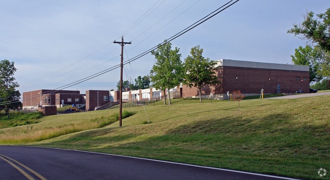
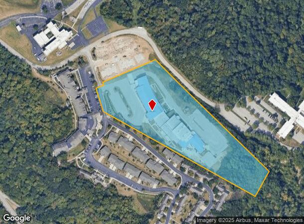
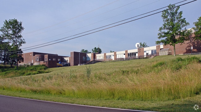
Property Record
501 Farrell Dr, Covington, KY 41011
NEARBY LISTINGS FOR SALE OR LEASE
Property Detail
501 Farrell Dr
042-30-00-006.00
7.354 A APPROX 200 FT SOUTH OF FARRELL DR INCL AN EASEMENT FOR INGRESS EGRESS
Publicschool
Kenton
X
Kentucky
21037C0025E
7.82 AC
0
Outlying N Kentucky
2025
Cincinnati/Dayton
065200
Cincinnati, OH-KY-IN
DEMOGRAPHICS near 501 Farrell Dr
1 Mile
3 Mile
5 Mile
2024 Total Population
7,446
75,737
212,952
2029 Population
7,612
77,665
217,453
Pop Growth 2024-2029
+ 2.23%
+ 2.55%
+ 2.11%
Average Age
41
40
39
2024 Total Households
3,382
33,627
93,871
HH Growth 2024-2029
+ 2.16%
+ 2.57%
+ 2.18%
Median Household Inc
$52,318
$57,616
$63,441
Avg Household Size
2.10
2.20
2.20
2024 Avg HH Vehicles
1.00
2.00
2.00
Median Home Value
$212,097
$225,838
$219,392
Median Year Built
1961
1959
1963
Nearby Places
Map Layers
Map Styles
 Street
 Aerial
- Restaurants
- Banks
- Shops
- Fitness
- Groceries
PUBLIC TRANSPORTATION
COMMUTER RAIL
Cincinnati Union Terminal (Cardinal - Amtrak)
DRIVE
WALK
Distance
Cincinnati Union Terminal (Cardinal - Amtrak)
12 min
6.0 mi
AIRPORT
Cincinnati/Northern Kentucky International
DRIVE
WALK
Distance
Cincinnati/Northern Kentucky International
24 min
11.1 mi
Freight Ports
Port of Toledo
DRIVE
WALK
Distance
Port of Toledo
249 min
210.6 mi
Nearby Properties
Address
Land Use
TOTAL SIZE
Lot Size
Zoning
Address
Land Use
TOTAL SIZE
Lot Size
Zoning
Address
Land Use
TOTAL SIZE
Lot Size
Zoning
60,750 SF
1.52 AC
Address
Land Use
TOTAL SIZE
Lot Size
Zoning
2.60 AC
Address
Land Use
TOTAL SIZE
Lot Size
Zoning
19.43 AC
Address
Land Use
TOTAL SIZE
Lot Size
Zoning
360,000 SF
Address
Land Use
TOTAL SIZE
Lot Size
Zoning
89,500 SF
0.58 AC
Address
Land Use
TOTAL SIZE
Lot Size
Zoning
290,233 SF
Address
Land Use
TOTAL SIZE
Lot Size
Zoning
9,962 SF
712 AC
Address
Land Use
TOTAL SIZE
Lot Size
Zoning
441,907 SF
Address
Land Use
TOTAL SIZE
Lot Size
Zoning
21.55 AC
Address
Land Use
TOTAL SIZE
Lot Size
Zoning
20.02 AC
Address
Land Use
TOTAL SIZE
Lot Size
Zoning
12.13 AC
Address
Land Use
TOTAL SIZE
Lot Size
Zoning
Address
Land Use
TOTAL SIZE
Lot Size
Zoning
30.11 AC
Address
Land Use
TOTAL SIZE
Lot Size
Zoning
20.49 AC
Address
Land Use
TOTAL SIZE
Lot Size
Zoning
263,300 SF
1.74 AC
Address
Land Use
TOTAL SIZE
Lot Size
Zoning
15.05 AC
Address
Land Use
TOTAL SIZE
Lot Size
Zoning
Address
Land Use
TOTAL SIZE
Lot Size
Zoning
108,958 SF
2.12 AC
Address
Land Use
TOTAL SIZE
Lot Size
Zoning
204,000 SF
2.14 AC
Address
Land Use
TOTAL SIZE
Lot Size
Zoning
7,965 SF
1.13 AC
Address
Land Use
TOTAL SIZE
Lot Size
Zoning
16.52 AC
Address
Land Use
TOTAL SIZE
Lot Size
Zoning
137,000 SF
0.58 AC
Address
Land Use
TOTAL SIZE
Lot Size
Zoning
57,189 SF
0.66 AC
Address
Land Use
TOTAL SIZE
Lot Size
Zoning
38,503 SF
0.83 AC
Address
Land Use
TOTAL SIZE
Lot Size
Zoning
12.60 AC
Address
Land Use
TOTAL SIZE
Lot Size
Zoning
85,726 SF
15.07 AC
Address
Land Use
TOTAL SIZE
Lot Size
Zoning
Address
Land Use
TOTAL SIZE
Lot Size
Zoning
The World's #1 Commercial Real Estate Marketplace
Connect with us
© 2025 CoStar Group
The information above has been obtained from sources believed reliable. While we do not doubt its accuracy we have not verified it and make no guarantee, warranty or representation about it. It is your responsibility to independently confirm its accuracy and completeness. Any projections, opinions, assumptions, or estimates used are for example only and do not represent the current or future performance of the property. The value of this transaction to you depends on tax and other factors which should be evaluated by your tax, financial, and legal advisors. You and your advisors should conduct a careful, independent investigation of the property to determine to your satisfaction the suitability of the property for your needs.