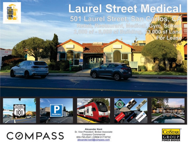
Property Record
501 Laurel St, San Carlos, CA 94070


Current Lease Availabilities
NEARBY LISTINGS FOR SALE OR LEASE
-
-
View all San Carlos listings for lease on LoopNet.com
Property Detail
501 Laurel St
San Francisco-Redwood City-South San Francisco, CA
Town Of San Carlos
050-074-210
LOTS 7 A 7 B 7 C 7 D & 7 E BLOCK 10 AMEND MAP TOWN OF SAN CARLOS
Officebuilding
San Mateo
X
California
06081C0169G
7
2024
0.33 AC
2025
Belmont/San Carlos
609202
San Francisco
5,650 SF
DEMOGRAPHICS near 501 Laurel St
1 Mile
3 Mile
5 Mile
2024 Total Population
15,755
133,996
272,039
2029 Population
15,106
127,880
259,782
Pop Growth 2024-2029
(4.12%)
(4.56%)
(4.51%)
Average Age
42
41
41
2024 Total Households
6,297
50,684
100,454
HH Growth 2024-2029
(4.11%)
(4.69%)
(4.66%)
Median Household Inc
$170,773
$166,059
$155,728
Avg Household Size
2.50
2.60
2.60
2024 Avg HH Vehicles
2.00
2.00
2.00
Median Home Value
$1,142,207
$1,134,207
$1,130,528
Median Year Built
1959
1969
1968
Nearby Places
Map Layers
Map Styles
 Street
 Aerial
- Restaurants
- Banks
- Shops
- Fitness
- Groceries
PUBLIC TRANSPORTATION
COMMUTER RAIL
San Carlos (Caltrain - Caltrain (Caltrain), Local Weekday - Caltrain (Caltrain), Local Weekend - Caltrain (Caltrain))
DRIVE
WALK
Distance
San Carlos (Caltrain - Caltrain (Caltrain), Local Weekday - Caltrain (Caltrain), Local Weekend - Caltrain (Caltrain))
0 min
6 min
0.2 mi
Belmont Caltrain Station Southbound (Local Weekday - Caltrain (Caltrain), Local Weekend - Caltrain (Caltrain))
DRIVE
WALK
Distance
Belmont Caltrain Station Southbound (Local Weekday - Caltrain (Caltrain), Local Weekend - Caltrain (Caltrain))
3 min
1.3 mi
AIRPORT
San Francisco International
DRIVE
WALK
Distance
San Francisco International
17 min
12.1 mi
Norman Y Mineta San Jose International
DRIVE
WALK
Distance
Norman Y Mineta San Jose International
29 min
22.1 mi
Metro Oakland International
DRIVE
WALK
Distance
Metro Oakland International
36 min
27.8 mi
Freight Ports
Port of Redwood City
DRIVE
WALK
Distance
Port of Redwood City
9 min
5.0 mi
Nearby Properties
Address
Land Use
TOTAL SIZE
Lot Size
Zoning
Address
Land Use
TOTAL SIZE
Lot Size
Zoning
1,068,445 SF
39.82 AC
Address
Land Use
TOTAL SIZE
Lot Size
Zoning
738,000 SF
56.46 AC
TP0000
Address
Land Use
TOTAL SIZE
Lot Size
Zoning
568,423 SF
16.07 AC
Address
Land Use
TOTAL SIZE
Lot Size
Zoning
8.31 AC
EA00CA
Address
Land Use
TOTAL SIZE
Lot Size
Zoning
491,030 SF
2.74 AC
Address
Land Use
TOTAL SIZE
Lot Size
Zoning
330,071 SF
1.64 AC
Address
Land Use
TOTAL SIZE
Lot Size
Zoning
Address
Land Use
TOTAL SIZE
Lot Size
Zoning
223,321 SF
8.39 AC
M10000
Address
Land Use
TOTAL SIZE
Lot Size
Zoning
Address
Land Use
TOTAL SIZE
Lot Size
Zoning
378,534 SF
2.24 AC
Address
Land Use
TOTAL SIZE
Lot Size
Zoning
40,000 SF
1.60 AC
Address
Land Use
TOTAL SIZE
Lot Size
Zoning
190,245 SF
16.88 AC
M10000
Address
Land Use
TOTAL SIZE
Lot Size
Zoning
2,020 SF
2.64 AC
Address
Land Use
TOTAL SIZE
Lot Size
Zoning
2,024 SF
2.07 AC
Address
Land Use
TOTAL SIZE
Lot Size
Zoning
245,260 SF
9.08 AC
Address
Land Use
TOTAL SIZE
Lot Size
Zoning
395,625 SF
5.08 AC
Address
Land Use
TOTAL SIZE
Lot Size
Zoning
458,111 SF
2.26 AC
Address
Land Use
TOTAL SIZE
Lot Size
Zoning
1,849 SF
4.72 AC
CB0000
Address
Land Use
TOTAL SIZE
Lot Size
Zoning
2.69 AC
ML001R
Address
Land Use
TOTAL SIZE
Lot Size
Zoning
12,944 SF
12.37 AC
Address
Land Use
TOTAL SIZE
Lot Size
Zoning
366,384 SF
3.63 AC
Address
Land Use
TOTAL SIZE
Lot Size
Zoning
249,198 SF
1.14 AC
Address
Land Use
TOTAL SIZE
Lot Size
Zoning
2,023 SF
1.31 AC
Address
Land Use
TOTAL SIZE
Lot Size
Zoning
262,189 SF
1.16 AC
Address
Land Use
TOTAL SIZE
Lot Size
Zoning
187,781 SF
6.67 AC
CP0000
Address
Land Use
TOTAL SIZE
Lot Size
Zoning
12.14 AC
Address
Land Use
TOTAL SIZE
Lot Size
Zoning
55,422 SF
2.41 AC
PM0002
Address
Land Use
TOTAL SIZE
Lot Size
Zoning
239,430 SF
17.78 AC
CB0000
Address
Land Use
TOTAL SIZE
Lot Size
Zoning
Address
Land Use
TOTAL SIZE
Lot Size
Zoning
204,006 SF
9.02 AC
TP0000
The World's #1 Commercial Real Estate Marketplace
Connect with us
© 2025 CoStar Group
The information above has been obtained from sources believed reliable. While we do not doubt its accuracy we have not verified it and make no guarantee, warranty or representation about it. It is your responsibility to independently confirm its accuracy and completeness. Any projections, opinions, assumptions, or estimates used are for example only and do not represent the current or future performance of the property. The value of this transaction to you depends on tax and other factors which should be evaluated by your tax, financial, and legal advisors. You and your advisors should conduct a careful, independent investigation of the property to determine to your satisfaction the suitability of the property for your needs.