Property Record
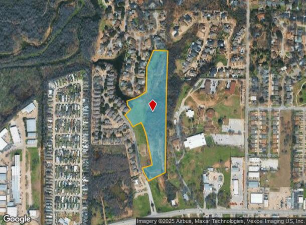
501 Lochngreen Trl, Arlington, TX 76012
NEARBY LISTINGS FOR SALE OR LEASE
Property Detail
501 Lochngreen Trl
Dallas-Fort Worth-Arlington, TX
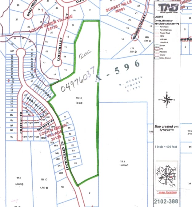
Guerrin, Heirs Survey
04976037
GUERRIN, HEIRS SURVEY ABSTRACT 596 TRACT 1C
Residentialacreage
Tarrant
AE
Texas
48439C0335K
12 AC
2024
Arlington/Mansfield
2025
Dallas/Ft Worth
121612
DEMOGRAPHICS near 501 Lochngreen Trl
1 mile
3 mile
5 mile
2024 Total Population
9,642
99,800
272,816
2029 Population
10,076
105,113
288,204
Pop Growth 2024-2029
+ 4.50%
+ 5.32%
+ 5.64%
Average Age
39
38
37
2024 Total Households
3,681
38,590
104,559
HH Growth 2024-2029
+ 4.54%
+ 5.36%
+ 5.76%
Median Household Inc
$72,700
$61,147
$56,999
Avg Household Size
2.50
2.40
2.50
2024 Avg HH Vehicles
2.00
2.00
2.00
Median Home Value
$249,774
$254,894
$244,557
Median Year Built
1973
1978
1979
Nearby Places
Map Layers
Map Styles
 Street
 Aerial
Transit
 Traffic
 Biking
Places
Listings with unknown addresses are not visible on the map
- Restaurants
- Banks
- Shops
- Fitness
- Groceries
PUBLIC TRANSPORTATION
COMMUTER RAIL
Hurst/Bell (TRINITY RAILWAY - Dallas Area Rapid Transit (DART), Trinity Railway Express - Dallas Area Rapid Transit (DART))
Drive
Walk
Distance
Hurst/Bell (TRINITY RAILWAY - Dallas Area Rapid Transit (DART), Trinity Railway Express - Dallas Area Rapid Transit (DART))
20 min
8.0 mi
AIRPORT
Dallas-Fort Worth International
Drive
Walk
Distance
Dallas-Fort Worth International
31 min
19.1 mi
Dallas Love Field
Drive
Walk
Distance
Dallas Love Field
40 min
27.0 mi
Freight Ports
Port of Shreveport
Drive
Walk
Distance
Port of Shreveport
240 min
219.4 mi
Nearby Properties
Address
Land Use
TOTAL SIZE
Lot Size
Zoning
Address
Land Use
TOTAL SIZE
Lot Size
Zoning
1,129,022 SF
16.84 AC
Address
Land Use
TOTAL SIZE
Lot Size
Zoning
320,636 SF
12.71 AC
Address
Land Use
TOTAL SIZE
Lot Size
Zoning
595,207 SF
7.20 AC
Address
Land Use
TOTAL SIZE
Lot Size
Zoning
492,970 SF
44.82 AC
Address
Land Use
TOTAL SIZE
Lot Size
Zoning
462,207 SF
2.82 AC
Address
Land Use
TOTAL SIZE
Lot Size
Zoning
492,837 SF
4.99 AC
Address
Land Use
TOTAL SIZE
Lot Size
Zoning
720,000 SF
9.80 AC
Address
Land Use
TOTAL SIZE
Lot Size
Zoning
288,378 SF
15.40 AC
Address
Land Use
TOTAL SIZE
Lot Size
Zoning
218,000 SF
3.98 AC
Address
Land Use
TOTAL SIZE
Lot Size
Zoning
386,575 SF
42.27 AC
Address
Land Use
TOTAL SIZE
Lot Size
Zoning
346,354 SF
4.25 AC
Address
Land Use
TOTAL SIZE
Lot Size
Zoning
242,811 SF
13.60 AC
Address
Land Use
TOTAL SIZE
Lot Size
Zoning
247,688 SF
11.75 AC
Address
Land Use
TOTAL SIZE
Lot Size
Zoning
268,643 SF
12.50 AC
Address
Land Use
TOTAL SIZE
Lot Size
Zoning
325,179 SF
15.64 AC
Address
Land Use
TOTAL SIZE
Lot Size
Zoning
205,410 SF
17.24 AC
Address
Land Use
TOTAL SIZE
Lot Size
Zoning
218,110 SF
8.85 AC
Address
Land Use
TOTAL SIZE
Lot Size
Zoning
206,098 SF
10 AC
Address
Land Use
TOTAL SIZE
Lot Size
Zoning
213,824 SF
11.66 AC
Address
Land Use
TOTAL SIZE
Lot Size
Zoning
187,988 SF
8.89 AC
Address
Land Use
TOTAL SIZE
Lot Size
Zoning
365,490 SF
3.84 AC
Address
Land Use
TOTAL SIZE
Lot Size
Zoning
48,538 SF
2.18 AC
Address
Land Use
TOTAL SIZE
Lot Size
Zoning
215,448 SF
9.13 AC
Address
Land Use
TOTAL SIZE
Lot Size
Zoning
195,010 SF
5.18 AC
Address
Land Use
TOTAL SIZE
Lot Size
Zoning
219,520 SF
13.50 AC
Address
Land Use
TOTAL SIZE
Lot Size
Zoning
176,735 SF
10.62 AC
Address
Land Use
TOTAL SIZE
Lot Size
Zoning
206,696 SF
9.92 AC
Address
Land Use
TOTAL SIZE
Lot Size
Zoning
128,208 SF
43.67 AC
Address
Land Use
TOTAL SIZE
Lot Size
Zoning
190,755 SF
33.09 AC
Address
Land Use
TOTAL SIZE
Lot Size
Zoning
193,909 SF
21.83 AC
The World's #1 Commercial Real Estate Marketplace
Connect with us
© 2026 CoStar Group
The information above has been obtained from sources believed reliable. While we do not doubt its accuracy we have not verified it and make no guarantee, warranty or representation about it. It is your responsibility to independently confirm its accuracy and completeness. Any projections, opinions, assumptions, or estimates used are for example only and do not represent the current or future performance of the property. The value of this transaction to you depends on tax and other factors which should be evaluated by your tax, financial, and legal advisors. You and your advisors should conduct a careful, independent investigation of the property to determine to your satisfaction the suitability of the property for your needs.