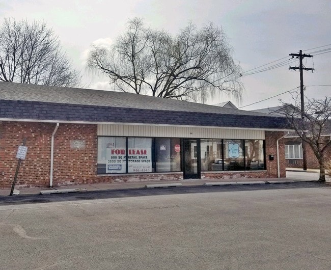
Property Record
501 Main St, Bellwood, PA 16617
NEARBY LISTINGS FOR SALE OR LEASE
-
-
View all Bellwood listings for lease on LoopNet.com
Property Detail
501 Main St
05-00007101
03 MAIN ST
Commercialofficeresidentialmixeduse
Blair
X
Pennsylvania
42013C0152D
0.24 AC
2025
Altoona/Johnstown
2025
Other Market Areas
010401
Altoona, PA
DEMOGRAPHICS near 501 Main St
1 Mile
3 Mile
5 Mile
2024 Total Population
3,220
7,100
15,888
2029 Population
3,176
7,076
15,909
Pop Growth 2024-2029
(1.37%)
(0.34%)
+ 0.13%
Average Age
42
44
43
2024 Total Households
1,297
2,943
6,505
HH Growth 2024-2029
(1.23%)
(0.17%)
+ 0.26%
Median Household Inc
$61,735
$64,821
$67,589
Avg Household Size
2.50
2.40
2.40
2024 Avg HH Vehicles
2.00
2.00
2.00
Median Home Value
$158,762
$167,802
$166,943
Median Year Built
1956
1975
1974
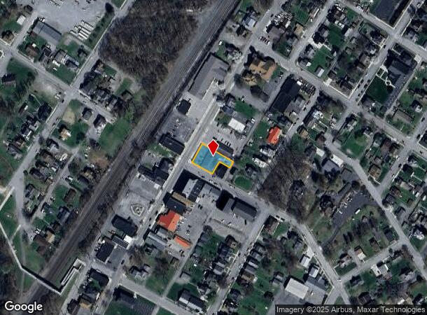
Nearby Places
Map Layers
Map Styles
 Street
 Aerial
- Restaurants
- Banks
- Shops
- Fitness
- Groceries
PUBLIC TRANSPORTATION
COMMUTER RAIL
Altoona Amtrak Station (Pennsylvanian - Amtrak)
DRIVE
WALK
Distance
Altoona Amtrak Station (Pennsylvanian - Amtrak)
14 min
7.4 mi
Tyrone Amtrak (Pennsylvanian - Amtrak)
DRIVE
WALK
Distance
Tyrone Amtrak (Pennsylvanian - Amtrak)
12 min
8.3 mi
Freight Ports
Port of Baltimore
DRIVE
WALK
Distance
Port of Baltimore
221 min
187.5 mi
SALE & LEASE HISTORY
LISTING DATE
SALE/LEASE

Apr 07, 2019
For Lease
Nearby Properties
Address
Land Use
TOTAL SIZE
Lot Size
Zoning
Address
Land Use
TOTAL SIZE
Lot Size
Zoning
17.19 AC
Address
Land Use
TOTAL SIZE
Lot Size
Zoning
Address
Land Use
TOTAL SIZE
Lot Size
Zoning
30.70 AC
Address
Land Use
TOTAL SIZE
Lot Size
Zoning
Address
Land Use
TOTAL SIZE
Lot Size
Zoning
42.52 AC
Address
Land Use
TOTAL SIZE
Lot Size
Zoning
119.43 AC
Address
Land Use
TOTAL SIZE
Lot Size
Zoning
8.44 AC
Address
Land Use
TOTAL SIZE
Lot Size
Zoning
2.31 AC
Address
Land Use
TOTAL SIZE
Lot Size
Zoning
Address
Land Use
TOTAL SIZE
Lot Size
Zoning
18.33 AC
Address
Land Use
TOTAL SIZE
Lot Size
Zoning
18.33 AC
Address
Land Use
TOTAL SIZE
Lot Size
Zoning
Address
Land Use
TOTAL SIZE
Lot Size
Zoning
27.40 AC
Address
Land Use
TOTAL SIZE
Lot Size
Zoning
Address
Land Use
TOTAL SIZE
Lot Size
Zoning
2.80 AC
Address
Land Use
TOTAL SIZE
Lot Size
Zoning
2.58 AC
Address
Land Use
TOTAL SIZE
Lot Size
Zoning
11.72 AC
Address
Land Use
TOTAL SIZE
Lot Size
Zoning
11.95 AC
Address
Land Use
TOTAL SIZE
Lot Size
Zoning
Address
Land Use
TOTAL SIZE
Lot Size
Zoning
Address
Land Use
TOTAL SIZE
Lot Size
Zoning
0.62 AC
Address
Land Use
TOTAL SIZE
Lot Size
Zoning
2.05 AC
Address
Land Use
TOTAL SIZE
Lot Size
Zoning
Address
Land Use
TOTAL SIZE
Lot Size
Zoning
Address
Land Use
TOTAL SIZE
Lot Size
Zoning
1.24 AC
Address
Land Use
TOTAL SIZE
Lot Size
Zoning
3.18 AC
Address
Land Use
TOTAL SIZE
Lot Size
Zoning
Address
Land Use
TOTAL SIZE
Lot Size
Zoning
3.55 AC
Address
Land Use
TOTAL SIZE
Lot Size
Zoning
2.37 AC
Address
Land Use
TOTAL SIZE
Lot Size
Zoning
12.42 AC
The World's #1 Commercial Real Estate Marketplace
Connect with us
© 2026 CoStar Group
The information above has been obtained from sources believed reliable. While we do not doubt its accuracy we have not verified it and make no guarantee, warranty or representation about it. It is your responsibility to independently confirm its accuracy and completeness. Any projections, opinions, assumptions, or estimates used are for example only and do not represent the current or future performance of the property. The value of this transaction to you depends on tax and other factors which should be evaluated by your tax, financial, and legal advisors. You and your advisors should conduct a careful, independent investigation of the property to determine to your satisfaction the suitability of the property for your needs.