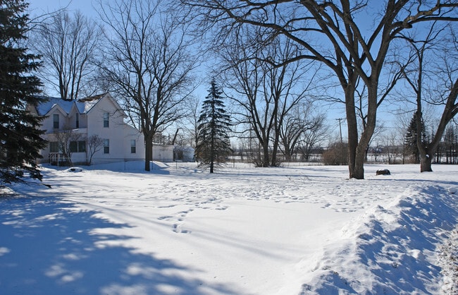
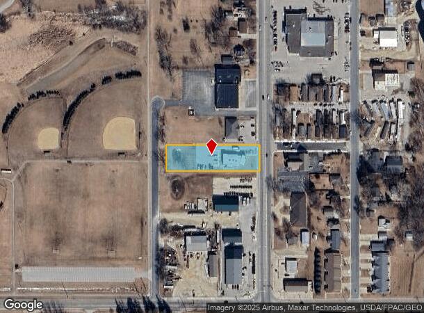
Property Record
501 Main St S, Stewartville, MN 55976
NEARBY LISTINGS FOR SALE OR LEASE
-
-
View all Stewartville listings for sale on LoopNet.com
Property Detail
501 Main St S
Rochester, MN
Wooldridges South Addition
54.34.34.083383
SECT-34 TWP-105 RANGE-014 WOOLDRIDGES SOUTH ADD LOT-006
Medicalclinic
Olmsted
X
Minnesota
27045C0025E
6
2025
0.92 AC
2024
Rochester
002100
Other Market Areas
4,380 SF
DEMOGRAPHICS near 501 Main St S
1 Mile
3 Mile
5 Mile
2024 Total Population
4,315
7,125
7,831
2029 Population
4,377
7,253
7,942
Pop Growth 2024-2029
+ 1.44%
+ 1.80%
+ 1.42%
Average Age
39
38
38
2024 Total Households
1,678
2,735
3,002
HH Growth 2024-2029
+ 1.31%
+ 1.72%
+ 1.33%
Median Household Inc
$81,359
$84,606
$85,821
Avg Household Size
2.50
2.60
2.60
2024 Avg HH Vehicles
2.00
2.00
2.00
Median Home Value
$270,020
$264,518
$269,726
Median Year Built
1977
1985
1984
Nearby Places
Map Layers
Map Styles
 Street
 Aerial
- Restaurants
- Banks
- Shops
- Fitness
- Groceries
PUBLIC TRANSPORTATION
AIRPORT
Rochester International
DRIVE
WALK
Distance
Rochester International
10 min
5.8 mi
Freight Ports
Port Milwaukee
DRIVE
WALK
Distance
Port Milwaukee
307 min
279.6 mi
SALE & LEASE HISTORY
LISTING DATE
SALE/LEASE

Sep 24, 2016
For Sale
Nearby Properties
Address
Land Use
TOTAL SIZE
Lot Size
Zoning
Address
Land Use
TOTAL SIZE
Lot Size
Zoning
968 SF
52.22 AC
Address
Land Use
TOTAL SIZE
Lot Size
Zoning
600 SF
18.52 AC
Address
Land Use
TOTAL SIZE
Lot Size
Zoning
58,144 SF
2.97 AC
Address
Land Use
TOTAL SIZE
Lot Size
Zoning
117,752 SF
19.92 AC
Address
Land Use
TOTAL SIZE
Lot Size
Zoning
12,032 SF
6.03 AC
Address
Land Use
TOTAL SIZE
Lot Size
Zoning
60,228 SF
7.51 AC
Address
Land Use
TOTAL SIZE
Lot Size
Zoning
Address
Land Use
TOTAL SIZE
Lot Size
Zoning
33.82 AC
Address
Land Use
TOTAL SIZE
Lot Size
Zoning
65,924 SF
15.14 AC
Address
Land Use
TOTAL SIZE
Lot Size
Zoning
49,931 SF
1.42 AC
Address
Land Use
TOTAL SIZE
Lot Size
Zoning
7,422 SF
13.57 AC
Address
Land Use
TOTAL SIZE
Lot Size
Zoning
13.02 AC
Address
Land Use
TOTAL SIZE
Lot Size
Zoning
35,011 SF
8.88 AC
Address
Land Use
TOTAL SIZE
Lot Size
Zoning
46,900 SF
3.14 AC
Address
Land Use
TOTAL SIZE
Lot Size
Zoning
29,609 SF
0.40 AC
Address
Land Use
TOTAL SIZE
Lot Size
Zoning
15,468 SF
2.34 AC
Address
Land Use
TOTAL SIZE
Lot Size
Zoning
231,582 SF
3.49 AC
Address
Land Use
TOTAL SIZE
Lot Size
Zoning
57,304 SF
8.43 AC
Address
Land Use
TOTAL SIZE
Lot Size
Zoning
21,600 SF
4.93 AC
Address
Land Use
TOTAL SIZE
Lot Size
Zoning
24,880 SF
4.80 AC
Address
Land Use
TOTAL SIZE
Lot Size
Zoning
864 SF
0.94 AC
Address
Land Use
TOTAL SIZE
Lot Size
Zoning
28,659 SF
44 SF
Address
Land Use
TOTAL SIZE
Lot Size
Zoning
22,324 SF
3.22 AC
Address
Land Use
TOTAL SIZE
Lot Size
Zoning
20,176 SF
1.38 AC
Address
Land Use
TOTAL SIZE
Lot Size
Zoning
30,786 SF
3.89 AC
Address
Land Use
TOTAL SIZE
Lot Size
Zoning
11.19 AC
Address
Land Use
TOTAL SIZE
Lot Size
Zoning
2,349 SF
14.10 AC
Address
Land Use
TOTAL SIZE
Lot Size
Zoning
1,614 SF
160 AC
Address
Land Use
TOTAL SIZE
Lot Size
Zoning
14,168 SF
11.86 AC
Address
Land Use
TOTAL SIZE
Lot Size
Zoning
14,246 SF
2.21 AC
The World's #1 Commercial Real Estate Marketplace
Connect with us
© 2026 CoStar Group
The information above has been obtained from sources believed reliable. While we do not doubt its accuracy we have not verified it and make no guarantee, warranty or representation about it. It is your responsibility to independently confirm its accuracy and completeness. Any projections, opinions, assumptions, or estimates used are for example only and do not represent the current or future performance of the property. The value of this transaction to you depends on tax and other factors which should be evaluated by your tax, financial, and legal advisors. You and your advisors should conduct a careful, independent investigation of the property to determine to your satisfaction the suitability of the property for your needs.