Property Record
501 Memorial Dr, Chicopee, MA 01020
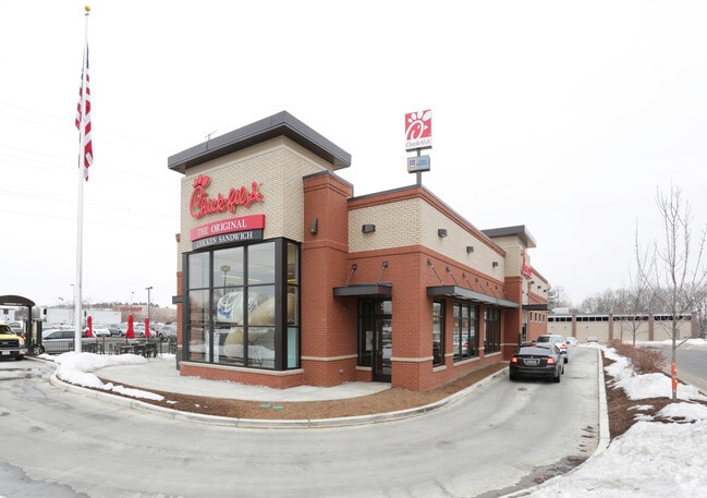

Property Detail
501 Memorial Dr
Restaurantbuilding
HAMPDEN
111A
Massachusetts
B and X Area of moderate flood hazard, usually the area between the limits of the 100-year and 500-year floods.
1.32 AC
2025
Hampden County
2025
Hartford
810601
Springfield, MA
4,749 SF
CHIC-000341-000000-000004A
NEARBY LISTINGS FOR SALE OR LEASE
DEMOGRAPHICS near 501 Memorial Dr
1 mile
3 mile
5 mile
2025 Total Population
7,771
96,085
227,583
2030 Population
7,743
96,518
228,025
Pop Growth 2025-2030
(0.36%)
+ 0.45%
+ 0.19%
Average Age
44
41
40
2025 Total Households
3,602
40,214
91,698
HH Growth 2025-2030
(0.33%)
+ 0.51%
+ 0.21%
Median Household Inc
$60,768
$60,859
$55,174
Avg Household Size
2.20
2.30
2.40
2025 Avg HH Vehicles
1.00
2.00
1.00
Median Home Value
$257,457
$267,517
$271,865
Median Year Built
1959
1962
1956
Nearby Places
Map Layers
Map Styles
 Street
 Aerial
Layers
 Traffic
 Biking
Places
Listings with unknown addresses are not visible on the map
- Restaurants
- Banks
- Shops
- Fitness
- Groceries
PUBLIC TRANSPORTATION
COMMUTER RAIL
Holyoke Amtrak (Valley Flyer - Amtrak, Vermonter - Amtrak)
Drive
Walk
Distance
Holyoke Amtrak (Valley Flyer - Amtrak, Vermonter - Amtrak)
9 min
4.0 mi
Springfield (Hartford Line - CONN DOT)
Drive
Walk
Distance
Springfield (Hartford Line - CONN DOT)
11 min
5.6 mi
AIRPORT
Bradley International
Drive
Walk
Distance
Bradley International
41 min
18.9 mi
Freight Ports
Port of New Haven
Drive
Walk
Distance
Port of New Haven
93 min
70.0 mi
Nearby Properties
Address
Land Use
TOTAL SIZE
Lot Size
Zoning
Address
Land Use
TOTAL SIZE
Lot Size
Zoning
48,924 SF
40.03 AC
I2
Address
Land Use
TOTAL SIZE
Lot Size
Zoning
21.80 AC
106
Address
Land Use
TOTAL SIZE
Lot Size
Zoning
286,624 SF
17.40 AC
102
Address
Land Use
TOTAL SIZE
Lot Size
Zoning
181,000 SF
34.48 AC
I1
Address
Land Use
TOTAL SIZE
Lot Size
Zoning
24.55 AC
102
Address
Land Use
TOTAL SIZE
Lot Size
Zoning
219,521 SF
7.50 AC
R2
Address
Land Use
TOTAL SIZE
Lot Size
Zoning
29.88 AC
105
Address
Land Use
TOTAL SIZE
Lot Size
Zoning
189,022 SF
10.62 AC
RA
Address
Land Use
TOTAL SIZE
Lot Size
Zoning
22.77 AC
111A
Address
Land Use
TOTAL SIZE
Lot Size
Zoning
99,792 SF
123.26 AC
S
Address
Land Use
TOTAL SIZE
Lot Size
Zoning
171,241 SF
18.94 AC
106
Address
Land Use
TOTAL SIZE
Lot Size
Zoning
30.45 AC
106
Address
Land Use
TOTAL SIZE
Lot Size
Zoning
181,008 SF
10 AC
102
Address
Land Use
TOTAL SIZE
Lot Size
Zoning
215,776 SF
28.52 AC
I1
Address
Land Use
TOTAL SIZE
Lot Size
Zoning
1.50 AC
105
Address
Land Use
TOTAL SIZE
Lot Size
Zoning
223,390 SF
13.83 AC
111A
Address
Land Use
TOTAL SIZE
Lot Size
Zoning
26.68 AC
110
Address
Land Use
TOTAL SIZE
Lot Size
Zoning
141,475 SF
31.69 AC
S
Address
Land Use
TOTAL SIZE
Lot Size
Zoning
2.41 AC
DR
Address
Land Use
TOTAL SIZE
Lot Size
Zoning
17.64 AC
105
Address
Land Use
TOTAL SIZE
Lot Size
Zoning
4.04 AC
107
Address
Land Use
TOTAL SIZE
Lot Size
Zoning
257,179 SF
22.84 AC
110
Address
Land Use
TOTAL SIZE
Lot Size
Zoning
6.81 AC
S
Address
Land Use
TOTAL SIZE
Lot Size
Zoning
67,500 SF
14.55 AC
I1
Address
Land Use
TOTAL SIZE
Lot Size
Zoning
51,100 SF
3.95 AC
R1
Address
Land Use
TOTAL SIZE
Lot Size
Zoning
81.65 AC
110
Address
Land Use
TOTAL SIZE
Lot Size
Zoning
320,639 SF
14.16 AC
110
Address
Land Use
TOTAL SIZE
Lot Size
Zoning
42,694 SF
2.38 AC
R2
Address
Land Use
TOTAL SIZE
Lot Size
Zoning
199,007 SF
50.95 AC
S
Address
Land Use
TOTAL SIZE
Lot Size
Zoning
4.66 AC
105
The World's #1 Commercial Real Estate Marketplace
Connect with us
© 2026 CoStar Group
The information above has been obtained from sources believed reliable. While we do not doubt its accuracy we have not verified it and make no guarantee, warranty or representation about it. It is your responsibility to independently confirm its accuracy and completeness. Any projections, opinions, assumptions, or estimates used are for example only and do not represent the current or future performance of the property. The value of this transaction to you depends on tax and other factors which should be evaluated by your tax, financial, and legal advisors. You and your advisors should conduct a careful, independent investigation of the property to determine to your satisfaction the suitability of the property for your needs.