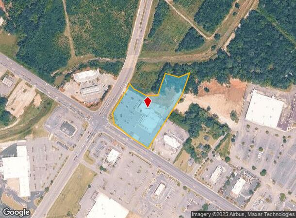
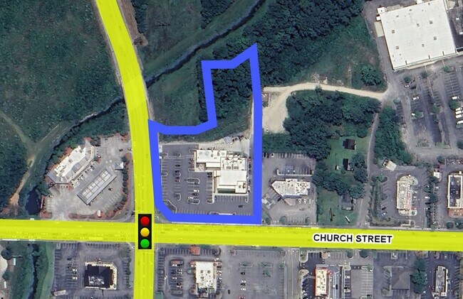
Property Record
501 Mill Pond Rd, Conway, SC 29526

NEARBY LISTINGS FOR SALE OR LEASE
Property Detail
501 Mill Pond Rd
33810010002
HWY 501 & MILL POND; TRACT 1
Restaurantbuilding
Horry
AE
South Carolina
45051C0527K
2.94 AC
2025
Conway
2024
Myrtle Beach/Conway
070102
Myrtle Beach-Conway-North Myrtle Beach, SC-NC
12,135 SF
DEMOGRAPHICS near 501 Mill Pond Rd
1 Mile
3 Mile
5 Mile
2024 Total Population
4,213
18,940
40,086
2029 Population
5,053
22,708
48,030
Pop Growth 2024-2029
+ 19.94%
+ 19.89%
+ 19.82%
Average Age
41
41
39
2024 Total Households
1,718
7,459
14,226
HH Growth 2024-2029
+ 18.45%
+ 18.50%
+ 18.94%
Median Household Inc
$38,537
$42,176
$46,865
Avg Household Size
2.40
2.40
2.50
2024 Avg HH Vehicles
1.00
2.00
2.00
Median Home Value
$173,185
$172,935
$176,954
Median Year Built
1979
1985
1990
Nearby Places
Map Layers
Map Styles
 Street
 Aerial
- Restaurants
- Banks
- Shops
- Fitness
- Groceries
PUBLIC TRANSPORTATION
AIRPORT
Myrtle Beach International
DRIVE
WALK
Distance
Myrtle Beach International
26 min
16.4 mi
Freight Ports
Port of Wilmington
DRIVE
WALK
Distance
Port of Wilmington
1 min
68.2 mi
SALE & LEASE HISTORY
LISTING DATE
SALE/LEASE

Oct 02, 2024
For Lease
Feb 20, 2024
For Sale
Nearby Properties
Address
Land Use
TOTAL SIZE
Lot Size
Zoning
Address
Land Use
TOTAL SIZE
Lot Size
Zoning
84,572 SF
15.01 AC
Address
Land Use
TOTAL SIZE
Lot Size
Zoning
200,089 SF
23.76 AC
Address
Land Use
TOTAL SIZE
Lot Size
Zoning
77.71 AC
Address
Land Use
TOTAL SIZE
Lot Size
Zoning
6,396 SF
45.01 AC
Address
Land Use
TOTAL SIZE
Lot Size
Zoning
50,500 SF
8.44 AC
Address
Land Use
TOTAL SIZE
Lot Size
Zoning
38,359 SF
3.50 AC
Address
Land Use
TOTAL SIZE
Lot Size
Zoning
27,284 SF
3.78 AC
Address
Land Use
TOTAL SIZE
Lot Size
Zoning
35,721 SF
8.07 AC
Address
Land Use
TOTAL SIZE
Lot Size
Zoning
75,020 SF
13.13 AC
Address
Land Use
TOTAL SIZE
Lot Size
Zoning
33,016 SF
12.09 AC
Address
Land Use
TOTAL SIZE
Lot Size
Zoning
41,447 SF
8.30 AC
Address
Land Use
TOTAL SIZE
Lot Size
Zoning
38,084 SF
6.41 AC
Address
Land Use
TOTAL SIZE
Lot Size
Zoning
29,993 SF
4.91 AC
Address
Land Use
TOTAL SIZE
Lot Size
Zoning
26,718 SF
6.04 AC
Address
Land Use
TOTAL SIZE
Lot Size
Zoning
43,918 SF
1.87 AC
Address
Land Use
TOTAL SIZE
Lot Size
Zoning
10,860 SF
5 AC
Address
Land Use
TOTAL SIZE
Lot Size
Zoning
10,596 SF
8.66 AC
Address
Land Use
TOTAL SIZE
Lot Size
Zoning
54,658 SF
4.37 AC
Address
Land Use
TOTAL SIZE
Lot Size
Zoning
27,098 SF
7.50 AC
Address
Land Use
TOTAL SIZE
Lot Size
Zoning
94,841 SF
9.38 AC
Address
Land Use
TOTAL SIZE
Lot Size
Zoning
7,112 SF
20.99 AC
Address
Land Use
TOTAL SIZE
Lot Size
Zoning
2,996 SF
3.20 AC
Address
Land Use
TOTAL SIZE
Lot Size
Zoning
99,577 SF
11.91 AC
Address
Land Use
TOTAL SIZE
Lot Size
Zoning
12.50 AC
Address
Land Use
TOTAL SIZE
Lot Size
Zoning
65.08 AC
Address
Land Use
TOTAL SIZE
Lot Size
Zoning
40,392 SF
8.91 AC
Address
Land Use
TOTAL SIZE
Lot Size
Zoning
24,360 SF
5.20 AC
Address
Land Use
TOTAL SIZE
Lot Size
Zoning
118.71 AC
Address
Land Use
TOTAL SIZE
Lot Size
Zoning
12,540 SF
10.64 AC
The World's #1 Commercial Real Estate Marketplace
Connect with us
© 2025 CoStar Group
The information above has been obtained from sources believed reliable. While we do not doubt its accuracy we have not verified it and make no guarantee, warranty or representation about it. It is your responsibility to independently confirm its accuracy and completeness. Any projections, opinions, assumptions, or estimates used are for example only and do not represent the current or future performance of the property. The value of this transaction to you depends on tax and other factors which should be evaluated by your tax, financial, and legal advisors. You and your advisors should conduct a careful, independent investigation of the property to determine to your satisfaction the suitability of the property for your needs.