Property Record
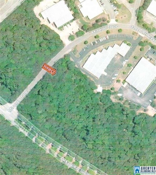
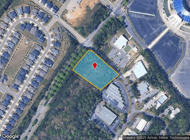
501 Mineral Trce, Hoover, AL 35244

This Property Is For Sale
NEARBY LISTINGS FOR SALE OR LEASE
Property Detail
501 Mineral Trce
39-00-33-4-000-002.000
COM SW COR OF SE1/4 OF SEC 33 TSP 19S R 3W TH N 900 FT E 440 FT TO SE BDRY OF STADIUM TRACE TH NE ALG SD R/W 550 FT TO POB TH CONT SAMRE COURSE 255.9 FT S ELYALG CURVEE 47.1 FT SE ALG MINERAL TRACE R/W 383.7 FT SW 250 FT NW 359 FT TO POB
Vacantlandnec
Jefferson
X
Alabama
01117C0203F
2.40 AC
2023
Hoover
2024
Birmingham
014410
Birmingham-Hoover, AL
DEMOGRAPHICS near 501 Mineral Trce
1 Mile
3 Mile
5 Mile
2024 Total Population
3,599
36,142
96,622
2029 Population
3,667
36,666
99,088
Pop Growth 2024-2029
+ 1.89%
+ 1.45%
+ 2.55%
Average Age
41
40
39
2024 Total Households
1,243
13,537
37,282
HH Growth 2024-2029
+ 1.77%
+ 1.52%
+ 2.36%
Median Household Inc
$156,468
$104,950
$89,659
Avg Household Size
2.90
2.60
2.50
2024 Avg HH Vehicles
2.00
2.00
2.00
Median Home Value
$436,399
$334,638
$288,358
Median Year Built
2006
1995
1993
Nearby Places
- Restaurants
- Banks
- Shops
- Fitness
- Groceries
PUBLIC TRANSPORTATION
AIRPORT
Birmingham-Shuttlesworth International
DRIVE
WALK
Distance
Birmingham-Shuttlesworth International
29 min
23.1 mi
Freight Ports
Port of Mobile
DRIVE
WALK
Distance
Port of Mobile
1 min
195.2 mi
Nearby Properties
Address
Land Use
TOTAL SIZE
Lot Size
Zoning
Address
Land Use
TOTAL SIZE
Lot Size
Zoning
582,638 SF
43.76 AC
PUDP
Address
Land Use
TOTAL SIZE
Lot Size
Zoning
186,953 SF
20 AC
PR2
Address
Land Use
TOTAL SIZE
Lot Size
Zoning
237,921 SF
6.35 AC
PUDP
Address
Land Use
TOTAL SIZE
Lot Size
Zoning
284,436 SF
40.98 AC
PUDP
Address
Land Use
TOTAL SIZE
Lot Size
Zoning
165,474 SF
90 AC
PR2
Address
Land Use
TOTAL SIZE
Lot Size
Zoning
238,304 SF
18.90 AC
PR-2
Address
Land Use
TOTAL SIZE
Lot Size
Zoning
200,679 SF
20 AC
PR2
Address
Land Use
TOTAL SIZE
Lot Size
Zoning
231,385 SF
50.40 AC
R6
Address
Land Use
TOTAL SIZE
Lot Size
Zoning
224,746 SF
46 AC
C2
Address
Land Use
TOTAL SIZE
Lot Size
Zoning
172,648 SF
39.45 AC
Address
Land Use
TOTAL SIZE
Lot Size
Zoning
230,053 SF
23 AC
Address
Land Use
TOTAL SIZE
Lot Size
Zoning
185,856 SF
6.70 AC
PC
Address
Land Use
TOTAL SIZE
Lot Size
Zoning
105,299 SF
25.50 AC
T3
Address
Land Use
TOTAL SIZE
Lot Size
Zoning
141,296 SF
14.51 AC
C2
Address
Land Use
TOTAL SIZE
Lot Size
Zoning
83,700 SF
60 AC
PC
Address
Land Use
TOTAL SIZE
Lot Size
Zoning
94,329 SF
15.60 AC
C1
Address
Land Use
TOTAL SIZE
Lot Size
Zoning
35,503 SF
2.92 AC
C2
Address
Land Use
TOTAL SIZE
Lot Size
Zoning
41,374 SF
3.70 AC
PUD-
Address
Land Use
TOTAL SIZE
Lot Size
Zoning
7,000 SF
19 AC
Address
Land Use
TOTAL SIZE
Lot Size
Zoning
29,302 SF
1.20 AC
A1
Address
Land Use
TOTAL SIZE
Lot Size
Zoning
108,525 SF
10.90 AC
PC
Address
Land Use
TOTAL SIZE
Lot Size
Zoning
23,493 SF
2.85 AC
C1
Address
Land Use
TOTAL SIZE
Lot Size
Zoning
64,321 SF
10.46 AC
PC
Address
Land Use
TOTAL SIZE
Lot Size
Zoning
76,255 SF
11.40 AC
C1
Address
Land Use
TOTAL SIZE
Lot Size
Zoning
106,917 SF
12.80 AC
Address
Land Use
TOTAL SIZE
Lot Size
Zoning
52,440 SF
10.40 AC
C2
Address
Land Use
TOTAL SIZE
Lot Size
Zoning
3.30 AC
C4
Address
Land Use
TOTAL SIZE
Lot Size
Zoning
91,213 SF
41 AC
Address
Land Use
TOTAL SIZE
Lot Size
Zoning
92,390 SF
3.30 AC
C2
Address
Land Use
TOTAL SIZE
Lot Size
Zoning
87,429 SF
6.80 AC
PC
The World's #1 Commercial Real Estate Marketplace
Connect with us
© 2025 CoStar Group
The information above has been obtained from sources believed reliable. While we do not doubt its accuracy we have not verified it and make no guarantee, warranty or representation about it. It is your responsibility to independently confirm its accuracy and completeness. Any projections, opinions, assumptions, or estimates used are for example only and do not represent the current or future performance of the property. The value of this transaction to you depends on tax and other factors which should be evaluated by your tax, financial, and legal advisors. You and your advisors should conduct a careful, independent investigation of the property to determine to your satisfaction the suitability of the property for your needs.