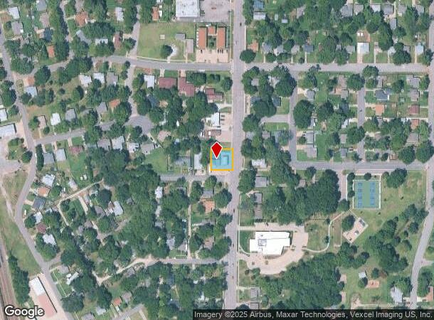
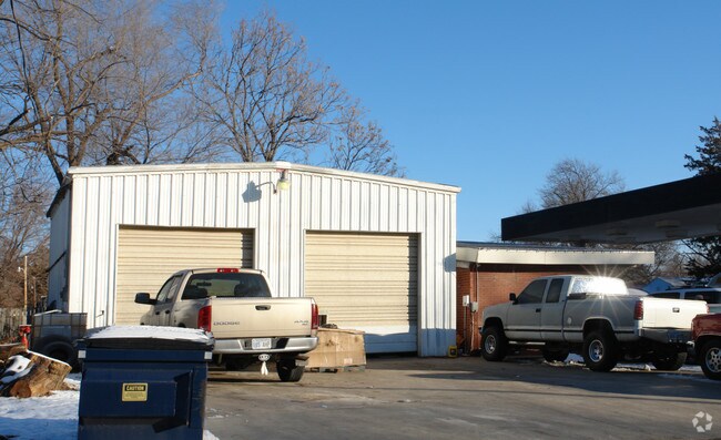
Property Record
501 N 2Nd Ave, Mulvane, KS 67110

NEARBY LISTINGS FOR SALE OR LEASE
Property Detail
501 N 2Nd Ave
239-31-0-41-06-021.00
BEG SE COR NE1/4 SE1/4 TH N 90 FT W 134 FT S 90 FT E TO BEG EXC E 42 FT DED TO CITY SEC 31-29-2E
Warehouse
Sedgwick
X
Kansas
20173C0676G
0.20 AC
2024
Derby/Haysville/Mulvane
2025
Wichita
009902
Wichita, KS
1,317 SF
DEMOGRAPHICS near 501 N 2Nd Ave
1 Mile
3 Mile
5 Mile
2024 Total Population
4,341
7,131
17,721
2029 Population
4,381
7,158
17,735
Pop Growth 2024-2029
+ 0.92%
+ 0.38%
+ 0.08%
Average Age
39
40
40
2024 Total Households
1,653
2,690
6,609
HH Growth 2024-2029
+ 0.97%
+ 0.45%
+ 0.09%
Median Household Inc
$57,845
$63,453
$73,395
Avg Household Size
2.60
2.60
2.60
2024 Avg HH Vehicles
2.00
2.00
2.00
Median Home Value
$146,197
$154,087
$179,270
Median Year Built
1975
1981
1981
Nearby Places
Map Layers
Map Styles
 Street
 Aerial
- Restaurants
- Banks
- Shops
- Fitness
- Groceries
PUBLIC TRANSPORTATION
AIRPORT
Wichita Dwight D Eisenhower Ntl
DRIVE
WALK
Distance
Wichita Dwight D Eisenhower Ntl
35 min
22.2 mi
Freight Ports
Tulsa Port Of Catoosa
DRIVE
WALK
Distance
Tulsa Port Of Catoosa
197 min
182.5 mi
SALE & LEASE HISTORY
LISTING DATE
SALE/LEASE

Nov 21, 2016
For Sale
Nearby Properties
Address
Land Use
TOTAL SIZE
Lot Size
Zoning
Address
Land Use
TOTAL SIZE
Lot Size
Zoning
138,281 SF
60.34 AC
Address
Land Use
TOTAL SIZE
Lot Size
Zoning
189,092 SF
35.98 AC
Address
Land Use
TOTAL SIZE
Lot Size
Zoning
127,266 SF
20.04 AC
Address
Land Use
TOTAL SIZE
Lot Size
Zoning
39,304 SF
2.80 AC
Address
Land Use
TOTAL SIZE
Lot Size
Zoning
14,026 SF
1.61 AC
Address
Land Use
TOTAL SIZE
Lot Size
Zoning
178,675 SF
Address
Land Use
TOTAL SIZE
Lot Size
Zoning
30,610 SF
3.46 AC
Address
Land Use
TOTAL SIZE
Lot Size
Zoning
28,000 SF
5.50 AC
Address
Land Use
TOTAL SIZE
Lot Size
Zoning
9,567 SF
4.01 AC
Address
Land Use
TOTAL SIZE
Lot Size
Zoning
17,548 SF
Address
Land Use
TOTAL SIZE
Lot Size
Zoning
17,047 SF
1.30 AC
Address
Land Use
TOTAL SIZE
Lot Size
Zoning
10,600 SF
4.90 AC
RR
Address
Land Use
TOTAL SIZE
Lot Size
Zoning
600 SF
Address
Land Use
TOTAL SIZE
Lot Size
Zoning
3,464 SF
1.90 AC
Address
Land Use
TOTAL SIZE
Lot Size
Zoning
14,095 SF
0.67 AC
Address
Land Use
TOTAL SIZE
Lot Size
Zoning
11,498 SF
1 AC
Address
Land Use
TOTAL SIZE
Lot Size
Zoning
4,290 SF
4.80 AC
Address
Land Use
TOTAL SIZE
Lot Size
Zoning
11,877 SF
4.39 AC
RR
Address
Land Use
TOTAL SIZE
Lot Size
Zoning
15,580 SF
4.91 AC
Address
Land Use
TOTAL SIZE
Lot Size
Zoning
3,750 SF
91.40 AC
Address
Land Use
TOTAL SIZE
Lot Size
Zoning
5,160 SF
3.86 AC
Address
Land Use
TOTAL SIZE
Lot Size
Zoning
21,692 SF
5.64 AC
Address
Land Use
TOTAL SIZE
Lot Size
Zoning
9,600 SF
9.16 AC
Address
Land Use
TOTAL SIZE
Lot Size
Zoning
5,964 SF
1.05 AC
Address
Land Use
TOTAL SIZE
Lot Size
Zoning
5,580 SF
1.40 AC
Address
Land Use
TOTAL SIZE
Lot Size
Zoning
960 SF
22.29 AC
Address
Land Use
TOTAL SIZE
Lot Size
Zoning
8,436 SF
0.43 AC
Address
Land Use
TOTAL SIZE
Lot Size
Zoning
5,720 SF
3.10 AC
Address
Land Use
TOTAL SIZE
Lot Size
Zoning
8,687 SF
0.71 AC
Address
Land Use
TOTAL SIZE
Lot Size
Zoning
4,793 SF
0.91 AC
The World's #1 Commercial Real Estate Marketplace
Connect with us
© 2025 CoStar Group
The information above has been obtained from sources believed reliable. While we do not doubt its accuracy we have not verified it and make no guarantee, warranty or representation about it. It is your responsibility to independently confirm its accuracy and completeness. Any projections, opinions, assumptions, or estimates used are for example only and do not represent the current or future performance of the property. The value of this transaction to you depends on tax and other factors which should be evaluated by your tax, financial, and legal advisors. You and your advisors should conduct a careful, independent investigation of the property to determine to your satisfaction the suitability of the property for your needs.