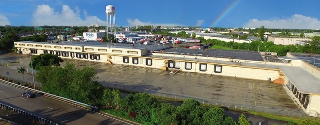
Property Record
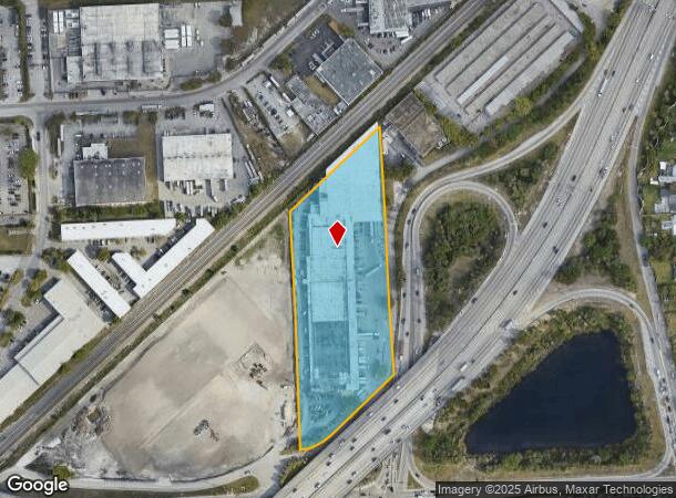
501 Ne 183Rd St, Miami, FL 33179

Current Lease Availabilities
NEARBY LISTINGS FOR SALE OR LEASE
Property Detail
501 Ne 183Rd St
30-2206-000-0101
Acreage
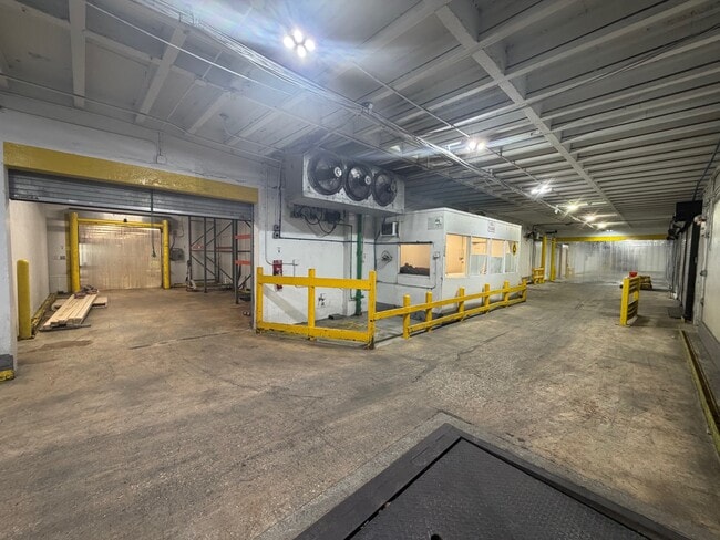
Foodprocessing
6-7 52 42 5.585 AC E300FT M/L OF E1/2 OF SE1/4 OF SE1/4 OF SW1/4 SE OF SAL RR SEC 6 &E300FT M/L OF E1/2 OF NE1/4 OF NE1/4 OF NW1/4 NW SR 9 SEC 7 LOT SIZE 243282 SQUARE FEET OR 14998-1148 0491 5
X
Miami/Dade
12086C0129L
Florida
2024
5.59 AC
2025
North Miami Beach
000213
South Florida
137,314 SF
Miami-Miami Beach-Kendall, FL
DEMOGRAPHICS near 501 Ne 183Rd St
1 Mile
3 Mile
5 Mile
2024 Total Population
23,480
200,537
553,586
2029 Population
23,099
197,762
551,742
Pop Growth 2024-2029
(1.62%)
(1.38%)
(0.33%)
Average Age
40
40
41
2024 Total Households
8,357
68,991
201,288
HH Growth 2024-2029
(1.74%)
(1.52%)
(0.20%)
Median Household Inc
$53,812
$51,229
$53,128
Avg Household Size
2.70
2.80
2.60
2024 Avg HH Vehicles
2.00
2.00
2.00
Median Home Value
$331,389
$289,964
$313,789
Median Year Built
1970
1970
1972
Nearby Places
Map Layers
Map Styles
 Street
 Aerial
- Restaurants
- Banks
- Shops
- Fitness
- Groceries
PUBLIC TRANSPORTATION
COMMUTER RAIL
Golden Glades (Tri-County Commuter - South Florida Regional Transportation Authority (Tri-Rail))
DRIVE
WALK
Distance
Golden Glades (Tri-County Commuter - South Florida Regional Transportation Authority (Tri-Rail))
6 min
2.9 mi
DRIVE
WALK
Distance
9 min
4.3 mi
AIRPORT
Fort Lauderdale/Hollywood International
DRIVE
WALK
Distance
Fort Lauderdale/Hollywood International
19 min
11.5 mi
Miami International
DRIVE
WALK
Distance
Miami International
34 min
18.5 mi
Nearby Properties
Address
Land Use
TOTAL SIZE
Lot Size
Zoning
Address
Land Use
TOTAL SIZE
Lot Size
Zoning
655,617 SF
16.35 AC
6574
Address
Land Use
TOTAL SIZE
Lot Size
Zoning
387,151 SF
7 AC
6400
Address
Land Use
TOTAL SIZE
Lot Size
Zoning
879,433 SF
1.78 AC
6405
Address
Land Use
TOTAL SIZE
Lot Size
Zoning
594,393 SF
12.30 AC
6000
Address
Land Use
TOTAL SIZE
Lot Size
Zoning
560,111 SF
2.57 AC
6400
Address
Land Use
TOTAL SIZE
Lot Size
Zoning
635,906 SF
19.70 AC
3800
Address
Land Use
TOTAL SIZE
Lot Size
Zoning
528,954 SF
3.85 AC
7703
Address
Land Use
TOTAL SIZE
Lot Size
Zoning
798,937 SF
15.25 AC
7100
Address
Land Use
TOTAL SIZE
Lot Size
Zoning
438,041 SF
17.43 AC
3800
Address
Land Use
TOTAL SIZE
Lot Size
Zoning
591,581 SF
4.22 AC
8000
Address
Land Use
TOTAL SIZE
Lot Size
Zoning
445,250 SF
1.77 AC
6572
Address
Land Use
TOTAL SIZE
Lot Size
Zoning
473,019 SF
24.10 AC
3800
Address
Land Use
TOTAL SIZE
Lot Size
Zoning
286,476 SF
24.21 AC
6800
Address
Land Use
TOTAL SIZE
Lot Size
Zoning
751,901 SF
16.65 AC
4100
Address
Land Use
TOTAL SIZE
Lot Size
Zoning
270,687 SF
7.06 AC
4100
Address
Land Use
TOTAL SIZE
Lot Size
Zoning
260,501 SF
20 AC
6110
Address
Land Use
TOTAL SIZE
Lot Size
Zoning
766,777 SF
31.65 AC
7300
Address
Land Use
TOTAL SIZE
Lot Size
Zoning
12,397 SF
10.79 AC
8600
Address
Land Use
TOTAL SIZE
Lot Size
Zoning
131,501 SF
9.97 AC
6000
Address
Land Use
TOTAL SIZE
Lot Size
Zoning
211,897 SF
18.22 AC
0100
Address
Land Use
TOTAL SIZE
Lot Size
Zoning
272,392 SF
2.69 AC
6000
Address
Land Use
TOTAL SIZE
Lot Size
Zoning
406,125 SF
2.29 AC
6000
Address
Land Use
TOTAL SIZE
Lot Size
Zoning
200,345 SF
11.08 AC
7300
Address
Land Use
TOTAL SIZE
Lot Size
Zoning
108,506 SF
6.71 AC
6000
Address
Land Use
TOTAL SIZE
Lot Size
Zoning
14.09 AC
8600
Address
Land Use
TOTAL SIZE
Lot Size
Zoning
299,305 SF
75 AC
9300
Address
Land Use
TOTAL SIZE
Lot Size
Zoning
191,138 SF
8 AC
4600
Address
Land Use
TOTAL SIZE
Lot Size
Zoning
369,472 SF
12 AC
3800
Address
Land Use
TOTAL SIZE
Lot Size
Zoning
310,293 SF
17.73 AC
9400
Address
Land Use
TOTAL SIZE
Lot Size
Zoning
236,332 SF
8.97 AC
7300
The World's #1 Commercial Real Estate Marketplace
Connect with us
© 2026 CoStar Group
The information above has been obtained from sources believed reliable. While we do not doubt its accuracy we have not verified it and make no guarantee, warranty or representation about it. It is your responsibility to independently confirm its accuracy and completeness. Any projections, opinions, assumptions, or estimates used are for example only and do not represent the current or future performance of the property. The value of this transaction to you depends on tax and other factors which should be evaluated by your tax, financial, and legal advisors. You and your advisors should conduct a careful, independent investigation of the property to determine to your satisfaction the suitability of the property for your needs.