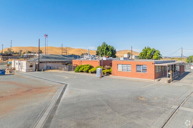
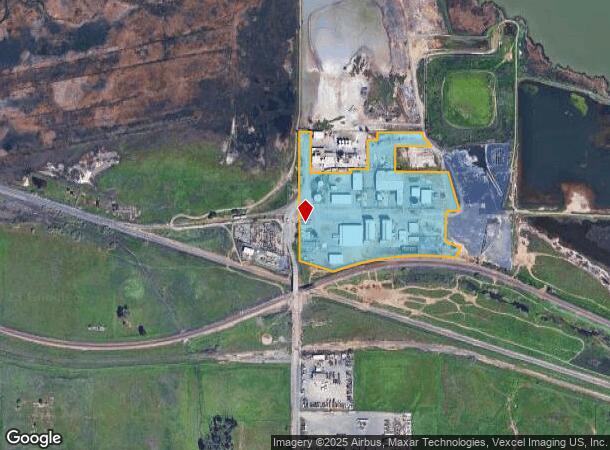
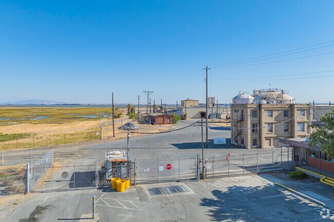
Property Record
501 Nichols Rd, Bay Point, CA 94565
NEARBY LISTINGS FOR SALE OR LEASE
Property Detail
501 Nichols Rd
Oakland-Fremont-Berkeley, CA
Parcel Map Subdivision Ms 04-0023
099-030-031-1
T193PM27 POR PCL A
Heavyindustrial
Contra Costa
AE
California
06095C0690F
13.61 AC
2025
Antioch/Pittsburg
2025
East Bay/Oakland
314200
DEMOGRAPHICS near 501 Nichols Rd
1 Mile
3 Mile
5 Mile
2024 Total Population
1,560
29,913
78,387
2029 Population
1,519
30,050
78,189
Pop Growth 2024-2029
(2.63%)
+ 0.46%
(0.25%)
Average Age
36
36
38
2024 Total Households
411
8,641
24,180
HH Growth 2024-2029
(2.68%)
+ 0.37%
(0.35%)
Median Household Inc
$84,589
$89,702
$100,240
Avg Household Size
3.60
3.30
3.10
2024 Avg HH Vehicles
3.00
2.00
2.00
Median Home Value
$545,833
$601,652
$606,209
Median Year Built
1966
1987
1976
Nearby Places
Map Layers
Map Styles
 Street
 Aerial
- Restaurants
- Banks
- Shops
- Fitness
- Groceries
PUBLIC TRANSPORTATION
AIRPORT
Metro Oakland International
DRIVE
WALK
Distance
Metro Oakland International
52 min
36.4 mi
Freight Ports
Port of Richmond
DRIVE
WALK
Distance
Port of Richmond
49 min
33.0 mi
Nearby Properties
Address
Land Use
TOTAL SIZE
Lot Size
Zoning
Address
Land Use
TOTAL SIZE
Lot Size
Zoning
516,154 SF
25.09 AC
Address
Land Use
TOTAL SIZE
Lot Size
Zoning
32,729 SF
7.61 AC
Address
Land Use
TOTAL SIZE
Lot Size
Zoning
270.45 AC
A2
Address
Land Use
TOTAL SIZE
Lot Size
Zoning
443.48 AC
Address
Land Use
TOTAL SIZE
Lot Size
Zoning
9,215 SF
14.73 AC
P1
Address
Land Use
TOTAL SIZE
Lot Size
Zoning
15,000 SF
8.33 AC
P1
Address
Land Use
TOTAL SIZE
Lot Size
Zoning
25.11 AC
P1
Address
Land Use
TOTAL SIZE
Lot Size
Zoning
98,377 SF
6.93 AC
LI
Address
Land Use
TOTAL SIZE
Lot Size
Zoning
83,769 SF
6.31 AC
Address
Land Use
TOTAL SIZE
Lot Size
Zoning
6,650 SF
11.70 AC
M29
Address
Land Use
TOTAL SIZE
Lot Size
Zoning
11,588 SF
3.65 AC
P1
Address
Land Use
TOTAL SIZE
Lot Size
Zoning
4,992 SF
15.14 AC
T1
Address
Land Use
TOTAL SIZE
Lot Size
Zoning
44,700 SF
32.28 AC
P1
Address
Land Use
TOTAL SIZE
Lot Size
Zoning
104,732 SF
5.99 AC
P1
Address
Land Use
TOTAL SIZE
Lot Size
Zoning
36,252 SF
3.94 AC
Address
Land Use
TOTAL SIZE
Lot Size
Zoning
56,146 SF
5 AC
Address
Land Use
TOTAL SIZE
Lot Size
Zoning
23,204 SF
1.11 AC
Address
Land Use
TOTAL SIZE
Lot Size
Zoning
60,426 SF
9.75 AC
Address
Land Use
TOTAL SIZE
Lot Size
Zoning
66,306 SF
7.74 AC
Address
Land Use
TOTAL SIZE
Lot Size
Zoning
15,168 SF
1.47 AC
P1
Address
Land Use
TOTAL SIZE
Lot Size
Zoning
1.99 AC
HI
Address
Land Use
TOTAL SIZE
Lot Size
Zoning
67,505 SF
5.68 AC
Address
Land Use
TOTAL SIZE
Lot Size
Zoning
55,247 SF
4.35 AC
Address
Land Use
TOTAL SIZE
Lot Size
Zoning
8.49 AC
LI
Address
Land Use
TOTAL SIZE
Lot Size
Zoning
44,246 SF
2.43 AC
Address
Land Use
TOTAL SIZE
Lot Size
Zoning
10,856 SF
2.91 AC
P1
Address
Land Use
TOTAL SIZE
Lot Size
Zoning
33,427 SF
2.18 AC
Address
Land Use
TOTAL SIZE
Lot Size
Zoning
1,999 SF
2.46 AC
Address
Land Use
TOTAL SIZE
Lot Size
Zoning
45.54 AC
A2
Address
Land Use
TOTAL SIZE
Lot Size
Zoning
14,070 SF
1.44 AC
The World's #1 Commercial Real Estate Marketplace
Connect with us
© 2026 CoStar Group
The information above has been obtained from sources believed reliable. While we do not doubt its accuracy we have not verified it and make no guarantee, warranty or representation about it. It is your responsibility to independently confirm its accuracy and completeness. Any projections, opinions, assumptions, or estimates used are for example only and do not represent the current or future performance of the property. The value of this transaction to you depends on tax and other factors which should be evaluated by your tax, financial, and legal advisors. You and your advisors should conduct a careful, independent investigation of the property to determine to your satisfaction the suitability of the property for your needs.