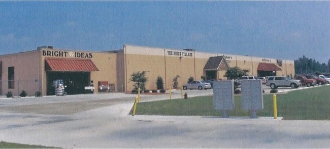
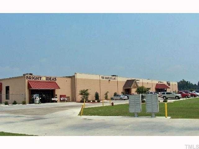
Property Record
501 Patetown Rd, Goldsboro, NC 27530

NEARBY LISTINGS FOR SALE OR LEASE
Property Detail
501 Patetown Rd
3600477436
Property Of Americal Corporation
Commercialnec
PATETOWN RD SR 1523
X
Wayne
3720360000K
North Carolina
2025
11.96 AC
2025
North Carolina Southeast Area
001200
Other Market Areas
64,740 SF
Goldsboro, NC
DEMOGRAPHICS near 501 Patetown Rd
1 Mile
3 Mile
5 Mile
2024 Total Population
1,969
24,114
48,777
2029 Population
1,981
24,452
49,012
Pop Growth 2024-2029
+ 0.61%
+ 1.40%
+ 0.48%
Average Age
42
41
40
2024 Total Households
933
10,176
19,996
HH Growth 2024-2029
+ 0.54%
+ 1.47%
+ 0.54%
Median Household Inc
$31,041
$36,076
$42,651
Avg Household Size
2.10
2.20
2.30
2024 Avg HH Vehicles
1.00
2.00
2.00
Median Home Value
$188,956
$184,168
$180,005
Median Year Built
1991
1973
1977
Nearby Places
Map Layers
Map Styles
 Street
 Aerial
- Restaurants
- Banks
- Shops
- Fitness
- Groceries
SALE & LEASE HISTORY
LISTING DATE
SALE/LEASE

Oct 10, 2016
For Sale
Nearby Properties
Address
Land Use
TOTAL SIZE
Lot Size
Zoning
Address
Land Use
TOTAL SIZE
Lot Size
Zoning
114.96 AC
Address
Land Use
TOTAL SIZE
Lot Size
Zoning
410,361 SF
186.26 AC
O&I
Address
Land Use
TOTAL SIZE
Lot Size
Zoning
200,000 SF
95.24 AC
O&I
Address
Land Use
TOTAL SIZE
Lot Size
Zoning
5,784 SF
18.48 AC
Address
Land Use
TOTAL SIZE
Lot Size
Zoning
88,715 SF
12.87 AC
Address
Land Use
TOTAL SIZE
Lot Size
Zoning
32,568 SF
2.90 AC
CBDH
Address
Land Use
TOTAL SIZE
Lot Size
Zoning
8,960 SF
13.22 AC
O&I
Address
Land Use
TOTAL SIZE
Lot Size
Zoning
21,152 SF
3.97 AC
Address
Land Use
TOTAL SIZE
Lot Size
Zoning
67,735 SF
42.36 AC
O&I
Address
Land Use
TOTAL SIZE
Lot Size
Zoning
57,824 SF
2.44 AC
Address
Land Use
TOTAL SIZE
Lot Size
Zoning
56,616 SF
2.38 AC
Address
Land Use
TOTAL SIZE
Lot Size
Zoning
59,680 SF
2.26 AC
Address
Land Use
TOTAL SIZE
Lot Size
Zoning
120,754 SF
8.32 AC
Address
Land Use
TOTAL SIZE
Lot Size
Zoning
8,100 SF
8.60 AC
Address
Land Use
TOTAL SIZE
Lot Size
Zoning
7,978 SF
2.24 AC
Address
Land Use
TOTAL SIZE
Lot Size
Zoning
94,776 SF
13.59 AC
O&I2
Address
Land Use
TOTAL SIZE
Lot Size
Zoning
49,557 SF
15 AC
Address
Land Use
TOTAL SIZE
Lot Size
Zoning
48,500 SF
0.12 AC
CBDH
Address
Land Use
TOTAL SIZE
Lot Size
Zoning
31,284 SF
3.97 AC
O&I
Address
Land Use
TOTAL SIZE
Lot Size
Zoning
51,688 SF
7.58 AC
GB
Address
Land Use
TOTAL SIZE
Lot Size
Zoning
53,125 SF
2 AC
HB
Address
Land Use
TOTAL SIZE
Lot Size
Zoning
10,000 SF
20.22 AC
Address
Land Use
TOTAL SIZE
Lot Size
Zoning
4,668 SF
15.72 AC
Address
Land Use
TOTAL SIZE
Lot Size
Zoning
82,655 SF
6.09 AC
SC
Address
Land Use
TOTAL SIZE
Lot Size
Zoning
54,407 SF
4 AC
I 5
Address
Land Use
TOTAL SIZE
Lot Size
Zoning
32,674 SF
7.97 AC
Address
Land Use
TOTAL SIZE
Lot Size
Zoning
7,912 SF
54.13 AC
I-2
Address
Land Use
TOTAL SIZE
Lot Size
Zoning
66,494 SF
4.15 AC
Address
Land Use
TOTAL SIZE
Lot Size
Zoning
29,260 SF
2.24 AC
GB
Address
Land Use
TOTAL SIZE
Lot Size
Zoning
65,966 SF
7.92 AC
GB
The World's #1 Commercial Real Estate Marketplace
Connect with us
© 2026 CoStar Group
The information above has been obtained from sources believed reliable. While we do not doubt its accuracy we have not verified it and make no guarantee, warranty or representation about it. It is your responsibility to independently confirm its accuracy and completeness. Any projections, opinions, assumptions, or estimates used are for example only and do not represent the current or future performance of the property. The value of this transaction to you depends on tax and other factors which should be evaluated by your tax, financial, and legal advisors. You and your advisors should conduct a careful, independent investigation of the property to determine to your satisfaction the suitability of the property for your needs.