Property Record
501 Pelham Dr, Columbia, SC 29209
NEARBY LISTINGS FOR SALE OR LEASE
-
-
View all Columbia listings for sale on LoopNet.com
Property Detail
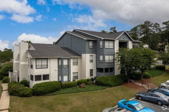
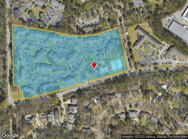
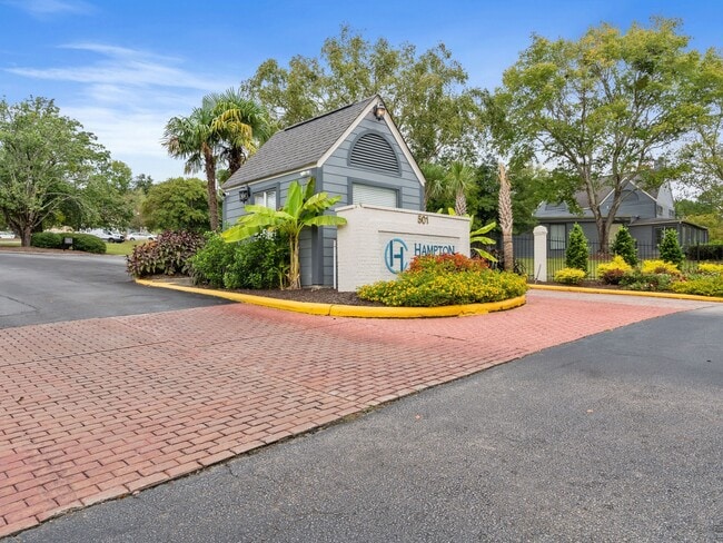
501 Pelham Dr
13715-01-01
Survey Of Hamtpn Courts Partments
Apartment
#SU HAMPTON COURT APARTMENTS #PR 54-9073 245-160
X
Richland
45079C0376L
South Carolina
0
15.66 AC
2024
Hopkins Suburban
011604
Columbia
216,180 SF
Columbia, SC
DEMOGRAPHICS near 501 Pelham Dr
1 Mile
3 Mile
5 Mile
2024 Total Population
7,936
67,491
139,589
2029 Population
8,017
68,593
142,733
Pop Growth 2024-2029
+ 1.02%
+ 1.63%
+ 2.25%
Average Age
38
36
36
2024 Total Households
3,978
28,303
56,365
HH Growth 2024-2029
+ 1.08%
+ 2.00%
+ 2.48%
Median Household Inc
$48,327
$57,264
$51,365
Avg Household Size
2.00
2.10
2.10
2024 Avg HH Vehicles
2.00
2.00
2.00
Median Home Value
$237,084
$273,727
$227,214
Median Year Built
1978
1973
1972
Nearby Places
Map Layers
Map Styles
 Street
 Aerial
- Restaurants
- Banks
- Shops
- Fitness
- Groceries
PUBLIC TRANSPORTATION
COMMUTER RAIL
Columbia Amtrak Station (Silver Star - Amtrak)
DRIVE
WALK
Distance
Columbia Amtrak Station (Silver Star - Amtrak)
14 min
5.7 mi
AIRPORT
Columbia Metro
DRIVE
WALK
Distance
Columbia Metro
29 min
16.6 mi
Freight Ports
North Charleston Terminal
DRIVE
WALK
Distance
North Charleston Terminal
123 min
108.0 mi
Nearby Properties
Address
Land Use
TOTAL SIZE
Lot Size
Zoning
Address
Land Use
TOTAL SIZE
Lot Size
Zoning
603,525 SF
26.45 AC
RM-HD
Address
Land Use
TOTAL SIZE
Lot Size
Zoning
604,350 SF
10.33 AC
EC
Address
Land Use
TOTAL SIZE
Lot Size
Zoning
316,116 SF
21.73 AC
RG-2
Address
Land Use
TOTAL SIZE
Lot Size
Zoning
241,878 SF
14.03 AC
C-3
Address
Land Use
TOTAL SIZE
Lot Size
Zoning
3,000 SF
52.49 AC
O-I
Address
Land Use
TOTAL SIZE
Lot Size
Zoning
300,636 SF
21.58 AC
LI
Address
Land Use
TOTAL SIZE
Lot Size
Zoning
13,028 SF
31.69 AC
RG-1
Address
Land Use
TOTAL SIZE
Lot Size
Zoning
95.26 AC
C-1
Address
Land Use
TOTAL SIZE
Lot Size
Zoning
486,050 SF
24.18 AC
RM-HD
Address
Land Use
TOTAL SIZE
Lot Size
Zoning
254,900 SF
14 AC
M-1
Address
Land Use
TOTAL SIZE
Lot Size
Zoning
230,053 SF
18.35 AC
C-3
Address
Land Use
TOTAL SIZE
Lot Size
Zoning
231,426 SF
10 AC
C-3
Address
Land Use
TOTAL SIZE
Lot Size
Zoning
32,640 SF
23.73 AC
RSF-2
Address
Land Use
TOTAL SIZE
Lot Size
Zoning
2,908 SF
87.03 AC
C-3
Address
Land Use
TOTAL SIZE
Lot Size
Zoning
212,787 SF
26.93 AC
C-3
Address
Land Use
TOTAL SIZE
Lot Size
Zoning
169,291 SF
18.97 AC
C-3
Address
Land Use
TOTAL SIZE
Lot Size
Zoning
239,827 SF
22.35 AC
HI
Address
Land Use
TOTAL SIZE
Lot Size
Zoning
174,424 SF
7.66 AC
LI
Address
Land Use
TOTAL SIZE
Lot Size
Zoning
9.66 AC
C-1
Address
Land Use
TOTAL SIZE
Lot Size
Zoning
129,721 SF
3.72 AC
C-3
Address
Land Use
TOTAL SIZE
Lot Size
Zoning
55,003 SF
4.26 AC
M-1
Address
Land Use
TOTAL SIZE
Lot Size
Zoning
281,304 SF
22.86 AC
RG-2
Address
Land Use
TOTAL SIZE
Lot Size
Zoning
285,760 SF
16.12 AC
RG-2
Address
Land Use
TOTAL SIZE
Lot Size
Zoning
90,984 SF
2.83 AC
C-1
Address
Land Use
TOTAL SIZE
Lot Size
Zoning
20 AC
C-3
Address
Land Use
TOTAL SIZE
Lot Size
Zoning
62,250 SF
8.15 AC
GC
Address
Land Use
TOTAL SIZE
Lot Size
Zoning
100 SF
16.95 AC
C-3
Address
Land Use
TOTAL SIZE
Lot Size
Zoning
199,263 SF
18.29 AC
C-3
Address
Land Use
TOTAL SIZE
Lot Size
Zoning
160,954 SF
24.03 AC
C-3
The World's #1 Commercial Real Estate Marketplace
Connect with us
© 2026 CoStar Group
The information above has been obtained from sources believed reliable. While we do not doubt its accuracy we have not verified it and make no guarantee, warranty or representation about it. It is your responsibility to independently confirm its accuracy and completeness. Any projections, opinions, assumptions, or estimates used are for example only and do not represent the current or future performance of the property. The value of this transaction to you depends on tax and other factors which should be evaluated by your tax, financial, and legal advisors. You and your advisors should conduct a careful, independent investigation of the property to determine to your satisfaction the suitability of the property for your needs.