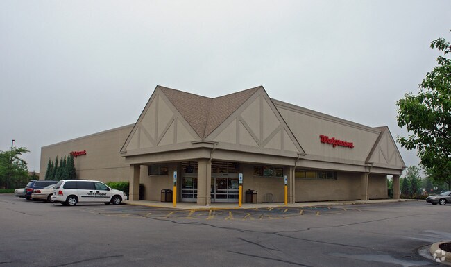
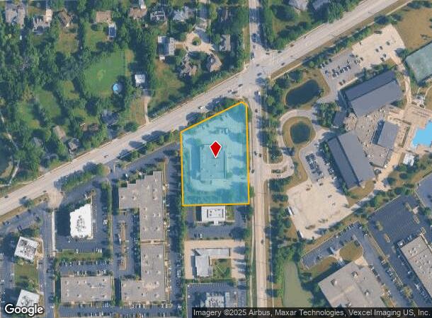
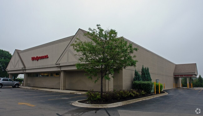
Property Record
501 Plainfield Rd, Willowbrook, IL 60527
NEARBY LISTINGS FOR SALE OR LEASE
Property Detail
501 Plainfield Rd
Chicago-Naperville-Elgin, IL-IN
Lamplighter Dev Sub
09-23-407-045
LAMPLIGHTER DEV SUB UNIT NO 1 /EX HWY DESC IN R87-111334/
Commercialnec
DuPage
X
Illinois
17043C0193J
1
2024
2.26 AC
2024
Eastern East/West Corr
845902
Chicago
13,777 SF
DEMOGRAPHICS near 501 Plainfield Rd
1 Mile
3 Mile
5 Mile
2024 Total Population
7,303
94,684
213,593
2029 Population
7,292
93,636
211,135
Pop Growth 2024-2029
(0.15%)
(1.11%)
(1.15%)
Average Age
48
43
43
2024 Total Households
2,918
37,216
82,401
HH Growth 2024-2029
(0.31%)
(1.26%)
(1.30%)
Median Household Inc
$116,885
$110,230
$108,611
Avg Household Size
2.40
2.50
2.50
2024 Avg HH Vehicles
2.00
2.00
2.00
Median Home Value
$422,815
$448,271
$444,166
Median Year Built
1978
1977
1975
Nearby Places
Map Layers
Map Styles
 Street
 Aerial
- Restaurants
- Banks
- Shops
- Fitness
- Groceries
PUBLIC TRANSPORTATION
COMMUTER RAIL
West Hinsdale Station (Burlington Northern-Santa Fe Railway Line - Northeast Illinois Regional Commuter Railroad (Metra))
DRIVE
WALK
Distance
West Hinsdale Station (Burlington Northern-Santa Fe Railway Line - Northeast Illinois Regional Commuter Railroad (Metra))
8 min
3.0 mi
Clarendon Hills Station (Burlington Northern-Santa Fe Railway Line - Northeast Illinois Regional Commuter Railroad (Metra))
DRIVE
WALK
Distance
Clarendon Hills Station (Burlington Northern-Santa Fe Railway Line - Northeast Illinois Regional Commuter Railroad (Metra))
8 min
3.7 mi
AIRPORT
Chicago Midway International
DRIVE
WALK
Distance
Chicago Midway International
18 min
10.5 mi
Chicago O'Hare International
DRIVE
WALK
Distance
Chicago O'Hare International
32 min
20.9 mi
Freight Ports
Port Milwaukee
DRIVE
WALK
Distance
Port Milwaukee
114 min
92.6 mi
Nearby Properties
Address
Land Use
TOTAL SIZE
Lot Size
Zoning
Address
Land Use
TOTAL SIZE
Lot Size
Zoning
439,070 SF
38.77 AC
C
Address
Land Use
TOTAL SIZE
Lot Size
Zoning
470,838 SF
17.13 AC
M
Address
Land Use
TOTAL SIZE
Lot Size
Zoning
183,080 SF
20.86 AC
C
Address
Land Use
TOTAL SIZE
Lot Size
Zoning
204,824 SF
15.05 AC
Address
Land Use
TOTAL SIZE
Lot Size
Zoning
368,233 SF
16.12 AC
Address
Land Use
TOTAL SIZE
Lot Size
Zoning
388,561 SF
12.77 AC
Address
Land Use
TOTAL SIZE
Lot Size
Zoning
274,406 SF
17.67 AC
M
Address
Land Use
TOTAL SIZE
Lot Size
Zoning
436,456 SF
59.11 AC
I
Address
Land Use
TOTAL SIZE
Lot Size
Zoning
182,295 SF
21.84 AC
C
Address
Land Use
TOTAL SIZE
Lot Size
Zoning
230,187 SF
15.38 AC
M
Address
Land Use
TOTAL SIZE
Lot Size
Zoning
202,562 SF
16.17 AC
M
Address
Land Use
TOTAL SIZE
Lot Size
Zoning
104,912 SF
6.91 AC
Address
Land Use
TOTAL SIZE
Lot Size
Zoning
108,021 SF
0.89 AC
Address
Land Use
TOTAL SIZE
Lot Size
Zoning
121,968 SF
2.07 AC
Address
Land Use
TOTAL SIZE
Lot Size
Zoning
94,064 SF
8.55 AC
Address
Land Use
TOTAL SIZE
Lot Size
Zoning
110,584 SF
5.57 AC
Address
Land Use
TOTAL SIZE
Lot Size
Zoning
23,043 SF
9.85 AC
M
Address
Land Use
TOTAL SIZE
Lot Size
Zoning
203,532 SF
6.85 AC
M
Address
Land Use
TOTAL SIZE
Lot Size
Zoning
146,856 SF
7.18 AC
A
Address
Land Use
TOTAL SIZE
Lot Size
Zoning
111,892 SF
8.69 AC
I
Address
Land Use
TOTAL SIZE
Lot Size
Zoning
22,770 SF
7.48 AC
M
Address
Land Use
TOTAL SIZE
Lot Size
Zoning
113,961 SF
6.94 AC
M
Address
Land Use
TOTAL SIZE
Lot Size
Zoning
8.91 AC
Address
Land Use
TOTAL SIZE
Lot Size
Zoning
195,000 SF
10.18 AC
Address
Land Use
TOTAL SIZE
Lot Size
Zoning
49,503 SF
1.47 AC
Address
Land Use
TOTAL SIZE
Lot Size
Zoning
215,631 SF
23.94 AC
I
Address
Land Use
TOTAL SIZE
Lot Size
Zoning
84,944 SF
6.82 AC
C
Address
Land Use
TOTAL SIZE
Lot Size
Zoning
73,004 SF
7.67 AC
Address
Land Use
TOTAL SIZE
Lot Size
Zoning
128,283 SF
6.89 AC
C
Address
Land Use
TOTAL SIZE
Lot Size
Zoning
52,887 SF
4.64 AC
C
The World's #1 Commercial Real Estate Marketplace
Connect with us
© 2026 CoStar Group
The information above has been obtained from sources believed reliable. While we do not doubt its accuracy we have not verified it and make no guarantee, warranty or representation about it. It is your responsibility to independently confirm its accuracy and completeness. Any projections, opinions, assumptions, or estimates used are for example only and do not represent the current or future performance of the property. The value of this transaction to you depends on tax and other factors which should be evaluated by your tax, financial, and legal advisors. You and your advisors should conduct a careful, independent investigation of the property to determine to your satisfaction the suitability of the property for your needs.