Property Record
501 Red Bud Dr, Azle, TX 76020


Save to a Folder
{{folder.Name}}
{{folder.ListingIds.length}} Properties
{{folder.ListingIds.length}} Property
Create a New Folder
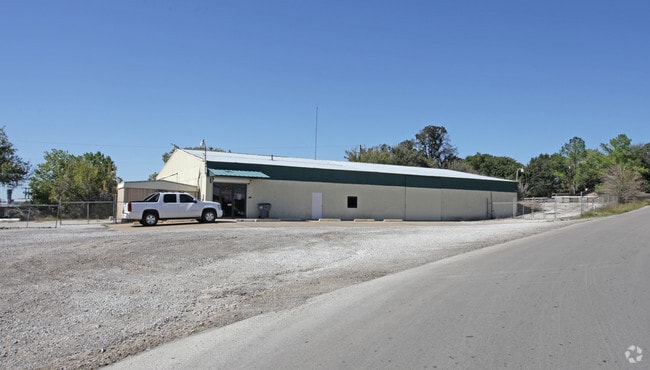
Property Detail
501 Red Bud Dr
Dallas-Fort Worth-Arlington, TX
ACRES: 2.300 LOT: 1 BLK: 1 SUBD: PIERCE ADDN
R000020964
Parker
Commercialnec
Texas
B and X Area of moderate flood hazard, usually the area between the limits of the 100-year and 500-year floods.
1
2024
2.30 AC
2025
Parker County
140412
Dallas/Ft Worth
10,380 SF
NEARBY LISTINGS FOR SALE OR LEASE
DEMOGRAPHICS near 501 Red Bud Dr
1 mile
3 mile
5 mile
2025 Total Population
5,274
25,266
44,973
2030 Population
5,850
28,007
50,236
Pop Growth 2025-2030
+ 10.92%
+ 10.85%
+ 11.70%
Average Age
38
40
41
2025 Total Households
1,977
9,459
16,654
HH Growth 2025-2030
+ 10.47%
+ 10.62%
+ 11.32%
Median Household Inc
$80,729
$79,028
$89,576
Avg Household Size
2.60
2.60
2.60
2025 Avg HH Vehicles
2.00
2.00
2.00
Median Home Value
$283,936
$317,039
$362,167
Median Year Built
1988
1990
1995
Nearby Places
Map Layers
Map Styles
 Street
 Aerial
Layers
 Traffic
 Biking
Places
Listings with unknown addresses are not visible on the map
- Restaurants
- Banks
- Shops
- Fitness
- Groceries
PUBLIC TRANSPORTATION
AIRPORT
Dallas-Fort Worth International
Drive
Walk
Distance
Dallas-Fort Worth International
51 min
38.9 mi
SALE & LEASE HISTORY
LISTING DATE
SALE/LEASE

Jul 23, 2024
For Sale
Nearby Properties
Address
Land Use
TOTAL SIZE
Lot Size
Zoning
Address
Land Use
TOTAL SIZE
Lot Size
Zoning
504.76 AC
Address
Land Use
TOTAL SIZE
Lot Size
Zoning
281,946 SF
16.01 AC
Address
Land Use
TOTAL SIZE
Lot Size
Zoning
228,201 SF
9.96 AC
Address
Land Use
TOTAL SIZE
Lot Size
Zoning
208,984 SF
14.42 AC
Address
Land Use
TOTAL SIZE
Lot Size
Zoning
262,793 SF
67.85 AC
Address
Land Use
TOTAL SIZE
Lot Size
Zoning
185,807 SF
14.03 AC
Address
Land Use
TOTAL SIZE
Lot Size
Zoning
43,610 SF
15.02 AC
Address
Land Use
TOTAL SIZE
Lot Size
Zoning
28,901 SF
14.03 AC
Address
Land Use
TOTAL SIZE
Lot Size
Zoning
62,068 SF
18.93 AC
Address
Land Use
TOTAL SIZE
Lot Size
Zoning
119.88 AC
Address
Land Use
TOTAL SIZE
Lot Size
Zoning
36,452 SF
10 AC
Address
Land Use
TOTAL SIZE
Lot Size
Zoning
221.50 AC
Address
Land Use
TOTAL SIZE
Lot Size
Zoning
105,385 SF
20 AC
Address
Land Use
TOTAL SIZE
Lot Size
Zoning
50,103 SF
11.48 AC
Address
Land Use
TOTAL SIZE
Lot Size
Zoning
62,536 SF
30.53 AC
Address
Land Use
TOTAL SIZE
Lot Size
Zoning
32,091 SF
117.44 AC
Address
Land Use
TOTAL SIZE
Lot Size
Zoning
1,728 SF
17.73 AC
Address
Land Use
TOTAL SIZE
Lot Size
Zoning
32,334 SF
3.52 AC
Address
Land Use
TOTAL SIZE
Lot Size
Zoning
69,227 SF
19.02 AC
Address
Land Use
TOTAL SIZE
Lot Size
Zoning
62,538 SF
9.19 AC
Address
Land Use
TOTAL SIZE
Lot Size
Zoning
Address
Land Use
TOTAL SIZE
Lot Size
Zoning
21,141 SF
4.14 AC
Address
Land Use
TOTAL SIZE
Lot Size
Zoning
90,949 SF
5.32 AC
Address
Land Use
TOTAL SIZE
Lot Size
Zoning
33,930 SF
18.70 AC
Address
Land Use
TOTAL SIZE
Lot Size
Zoning
71,740 SF
1.75 AC
Address
Land Use
TOTAL SIZE
Lot Size
Zoning
148.37 AC
Address
Land Use
TOTAL SIZE
Lot Size
Zoning
44,264 SF
2.57 AC
Address
Land Use
TOTAL SIZE
Lot Size
Zoning
41,371 SF
1.62 AC
Address
Land Use
TOTAL SIZE
Lot Size
Zoning
42,008 SF
4.13 AC
Address
Land Use
TOTAL SIZE
Lot Size
Zoning
56,296 SF
4.83 AC
The World's #1 Commercial Real Estate Marketplace
Connect with us
© 2026 CoStar Group
The information above has been obtained from sources believed reliable. While we do not doubt its accuracy we have not verified it and make no guarantee, warranty or representation about it. It is your responsibility to independently confirm its accuracy and completeness. Any projections, opinions, assumptions, or estimates used are for example only and do not represent the current or future performance of the property. The value of this transaction to you depends on tax and other factors which should be evaluated by your tax, financial, and legal advisors. You and your advisors should conduct a careful, independent investigation of the property to determine to your satisfaction the suitability of the property for your needs.