Property Record
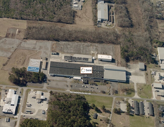
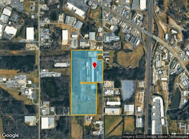
501 Richardson Rd Se, Calhoun, GA 30701
Current Lease Availabilities
NEARBY LISTINGS FOR SALE OR LEASE
Property Detail
501 Richardson Rd Se
C59-001
TAYSE
Industrialgeneral
Gordon
X
Georgia
13015C0050H
68.91 AC
2024
Georgia Northwest
2024
Other Market Areas
970602
Calhoun, GA
188,378 SF
DEMOGRAPHICS near 501 Richardson Rd Se
1 Mile
3 Mile
5 Mile
2024 Total Population
1,829
14,249
34,526
2029 Population
1,963
15,244
36,952
Pop Growth 2024-2029
+ 7.33%
+ 6.98%
+ 7.03%
Average Age
40
39
39
2024 Total Households
683
5,308
12,799
HH Growth 2024-2029
+ 7.03%
+ 6.74%
+ 6.82%
Median Household Inc
$44,721
$48,180
$48,284
Avg Household Size
2.60
2.60
2.60
2024 Avg HH Vehicles
2.00
2.00
2.00
Median Home Value
$175,297
$190,681
$179,773
Median Year Built
1980
1982
1988
Nearby Places
Map Layers
Map Styles
 Street
 Aerial
- Restaurants
- Banks
- Shops
- Fitness
- Groceries
Nearby Properties
Address
Land Use
TOTAL SIZE
Lot Size
Zoning
Address
Land Use
TOTAL SIZE
Lot Size
Zoning
740,998 SF
55.39 AC
IND-G
Address
Land Use
TOTAL SIZE
Lot Size
Zoning
215,296 SF
19.94 AC
R-2
Address
Land Use
TOTAL SIZE
Lot Size
Zoning
403,152 SF
8.33 AC
Address
Land Use
TOTAL SIZE
Lot Size
Zoning
740,750 SF
30.22 AC
IND-G
Address
Land Use
TOTAL SIZE
Lot Size
Zoning
474,912 SF
54.83 AC
IND-G
Address
Land Use
TOTAL SIZE
Lot Size
Zoning
408,600 SF
38.92 AC
I-2
Address
Land Use
TOTAL SIZE
Lot Size
Zoning
549,997 SF
138.47 AC
IND-G
Address
Land Use
TOTAL SIZE
Lot Size
Zoning
209,387 SF
42.22 AC
R-1
Address
Land Use
TOTAL SIZE
Lot Size
Zoning
454,680 SF
5.23 AC
IND-G
Address
Land Use
TOTAL SIZE
Lot Size
Zoning
192,578 SF
25.47 AC
C-N
Address
Land Use
TOTAL SIZE
Lot Size
Zoning
197,500 SF
14.55 AC
IND-G
Address
Land Use
TOTAL SIZE
Lot Size
Zoning
860,400 SF
19.85 AC
IND-G
Address
Land Use
TOTAL SIZE
Lot Size
Zoning
85,560 SF
3 AC
C-2
Address
Land Use
TOTAL SIZE
Lot Size
Zoning
96,647 SF
35.06 AC
I-2
Address
Land Use
TOTAL SIZE
Lot Size
Zoning
4,318 SF
19.26 AC
IND-G
Address
Land Use
TOTAL SIZE
Lot Size
Zoning
2,870 SF
11.02 AC
PRD
Address
Land Use
TOTAL SIZE
Lot Size
Zoning
26,922 SF
19.71 AC
C-4
Address
Land Use
TOTAL SIZE
Lot Size
Zoning
50,676 SF
19.74 AC
C-2
Address
Land Use
TOTAL SIZE
Lot Size
Zoning
2,899 SF
12 AC
Address
Land Use
TOTAL SIZE
Lot Size
Zoning
3,360 SF
25.27 AC
RC-1
Address
Land Use
TOTAL SIZE
Lot Size
Zoning
554,897 SF
42.41 AC
IND-G
Address
Land Use
TOTAL SIZE
Lot Size
Zoning
88,000 SF
8.87 AC
IND-G
Address
Land Use
TOTAL SIZE
Lot Size
Zoning
128,740 SF
42.95 AC
IND-G
Address
Land Use
TOTAL SIZE
Lot Size
Zoning
806,290 SF
74.96 AC
IND-G
Address
Land Use
TOTAL SIZE
Lot Size
Zoning
28,481 SF
24.41 AC
R-1B
Address
Land Use
TOTAL SIZE
Lot Size
Zoning
6,956 SF
7 AC
R-2
Address
Land Use
TOTAL SIZE
Lot Size
Zoning
281,810 SF
22.74 AC
IND-G
Address
Land Use
TOTAL SIZE
Lot Size
Zoning
96,533 SF
3.53 AC
R-2
Address
Land Use
TOTAL SIZE
Lot Size
Zoning
4,357 SF
34.97 AC
R-2
Address
Land Use
TOTAL SIZE
Lot Size
Zoning
207,900 SF
13.43 AC
IND-G
The World's #1 Commercial Real Estate Marketplace
Connect with us
© 2025 CoStar Group
The information above has been obtained from sources believed reliable. While we do not doubt its accuracy we have not verified it and make no guarantee, warranty or representation about it. It is your responsibility to independently confirm its accuracy and completeness. Any projections, opinions, assumptions, or estimates used are for example only and do not represent the current or future performance of the property. The value of this transaction to you depends on tax and other factors which should be evaluated by your tax, financial, and legal advisors. You and your advisors should conduct a careful, independent investigation of the property to determine to your satisfaction the suitability of the property for your needs.