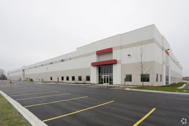
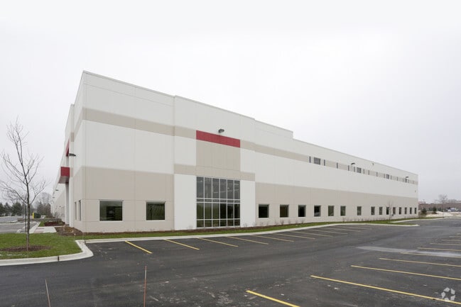
Property Record
501 S Gary Ave, Roselle, IL 60172


Property Detail
501 S Gary Ave
02-08-217-033
TURNBERRY LAKES SUB /EX HWY DESC 22-099799/
Industrialgeneral
DUPAGE
I
Illinois
B and X Area of moderate flood hazard, usually the area between the limits of the 100-year and 500-year floods.
10.67 AC
2024
North DuPage
2024
Chicago
841102
Chicago-Naperville-Elgin, IL-IN
154,126 SF
NEARBY LISTINGS FOR SALE OR LEASE
DEMOGRAPHICS near 501 S Gary Ave
1 mile
3 mile
5 mile
2025 Total Population
11,022
102,612
297,675
2030 Population
11,146
103,354
299,412
Pop Growth 2025-2030
+ 1.13%
+ 0.72%
+ 0.58%
Average Age
40
41
41
2025 Total Households
4,035
36,012
105,330
HH Growth 2025-2030
+ 0.97%
+ 0.62%
+ 0.47%
Median Household Inc
$112,873
$102,584
$102,070
Avg Household Size
2.70
2.80
2.70
2025 Avg HH Vehicles
2.00
2.00
2.00
Median Home Value
$315,911
$323,451
$319,141
Median Year Built
1979
1978
1978
Nearby Places
Map Layers
Map Styles
 Street
 Aerial
Layers
 Traffic
 Biking
Places
Listings with unknown addresses are not visible on the map
- Restaurants
- Banks
- Shops
- Fitness
- Groceries
PUBLIC TRANSPORTATION
COMMUTER RAIL
Hanover Park Station (Milwaukee District West Line - Northeast Illinois Regional Commuter Railroad (Metra))
Drive
Walk
Distance
Hanover Park Station (Milwaukee District West Line - Northeast Illinois Regional Commuter Railroad (Metra))
5 min
2.4 mi
Schaumburg Station (Milwaukee District West Line - Northeast Illinois Regional Commuter Railroad (Metra))
Drive
Walk
Distance
Schaumburg Station (Milwaukee District West Line - Northeast Illinois Regional Commuter Railroad (Metra))
7 min
3.1 mi
AIRPORT
Chicago O'Hare International
Drive
Walk
Distance
Chicago O'Hare International
31 min
18.7 mi
Chicago Midway International
Drive
Walk
Distance
Chicago Midway International
42 min
27.6 mi
Freight Ports
Port Milwaukee
Drive
Walk
Distance
Port Milwaukee
110 min
89.8 mi
Nearby Properties
Address
Land Use
TOTAL SIZE
Lot Size
Zoning
Address
Land Use
TOTAL SIZE
Lot Size
Zoning
345,600 SF
23.40 AC
M
Address
Land Use
TOTAL SIZE
Lot Size
Zoning
322,680 SF
19.07 AC
M
Address
Land Use
TOTAL SIZE
Lot Size
Zoning
236,871 SF
12.84 AC
M
Address
Land Use
TOTAL SIZE
Lot Size
Zoning
251,091 SF
32.67 AC
R-4
Address
Land Use
TOTAL SIZE
Lot Size
Zoning
226,069 SF
14.85 AC
Address
Land Use
TOTAL SIZE
Lot Size
Zoning
492,570 SF
22.46 AC
I
Address
Land Use
TOTAL SIZE
Lot Size
Zoning
306,870 SF
31.76 AC
I
Address
Land Use
TOTAL SIZE
Lot Size
Zoning
356,177 SF
18.27 AC
I
Address
Land Use
TOTAL SIZE
Lot Size
Zoning
320,504 SF
17.60 AC
I
Address
Land Use
TOTAL SIZE
Lot Size
Zoning
79,397 SF
13.98 AC
I
Address
Land Use
TOTAL SIZE
Lot Size
Zoning
361,130 SF
19.91 AC
I
Address
Land Use
TOTAL SIZE
Lot Size
Zoning
156,493 SF
13.35 AC
C
Address
Land Use
TOTAL SIZE
Lot Size
Zoning
320,430 SF
16.56 AC
I
Address
Land Use
TOTAL SIZE
Lot Size
Zoning
138,515 SF
5.28 AC
C
Address
Land Use
TOTAL SIZE
Lot Size
Zoning
288,366 SF
26.17 AC
I
Address
Land Use
TOTAL SIZE
Lot Size
Zoning
Address
Land Use
TOTAL SIZE
Lot Size
Zoning
221,126 SF
9.06 AC
I
Address
Land Use
TOTAL SIZE
Lot Size
Zoning
101,282 SF
2.34 AC
Address
Land Use
TOTAL SIZE
Lot Size
Zoning
24.08 AC
Address
Land Use
TOTAL SIZE
Lot Size
Zoning
357,241 SF
25.69 AC
Address
Land Use
TOTAL SIZE
Lot Size
Zoning
216,238 SF
13.52 AC
Address
Land Use
TOTAL SIZE
Lot Size
Zoning
271,680 SF
17.07 AC
I
Address
Land Use
TOTAL SIZE
Lot Size
Zoning
346,165 SF
3.15 AC
Address
Land Use
TOTAL SIZE
Lot Size
Zoning
130,923 SF
13.15 AC
Address
Land Use
TOTAL SIZE
Lot Size
Zoning
117,721 SF
13.95 AC
C
Address
Land Use
TOTAL SIZE
Lot Size
Zoning
229,759 SF
12.90 AC
I
Address
Land Use
TOTAL SIZE
Lot Size
Zoning
250,000 SF
12.44 AC
I
Address
Land Use
TOTAL SIZE
Lot Size
Zoning
244,888 SF
12.19 AC
I
Address
Land Use
TOTAL SIZE
Lot Size
Zoning
242,800 SF
16.43 AC
Address
Land Use
TOTAL SIZE
Lot Size
Zoning
176,005 SF
15.10 AC
C
The World's #1 Commercial Real Estate Marketplace
Connect with us
© 2026 CoStar Group
The information above has been obtained from sources believed reliable. While we do not doubt its accuracy we have not verified it and make no guarantee, warranty or representation about it. It is your responsibility to independently confirm its accuracy and completeness. Any projections, opinions, assumptions, or estimates used are for example only and do not represent the current or future performance of the property. The value of this transaction to you depends on tax and other factors which should be evaluated by your tax, financial, and legal advisors. You and your advisors should conduct a careful, independent investigation of the property to determine to your satisfaction the suitability of the property for your needs.