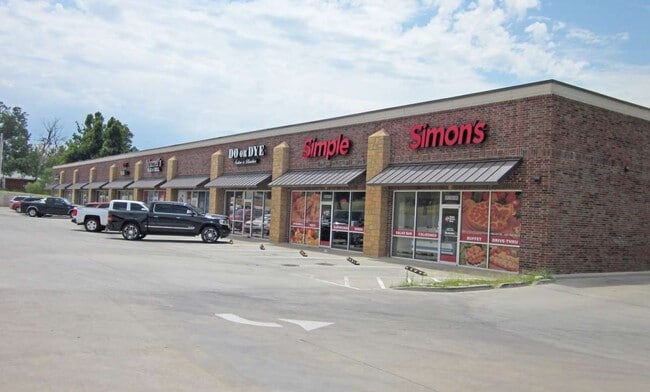
Property Record
501 S Harrah Rd, Harrah, OK 73045

Current Lease Availabilities
Property Detail
501 S Harrah Rd
Oklahoma City, OK
FALL CREEK SEC II PH I BLK 024 PT OF LOT 2 BEG 2274.97FT E & 881.36FT S & 1035FT W & 260.99FT S & 895.85FT SE & 225FT SW & 245.26FT SE & 454.32FT NE & 444.02FT NE & 114.69FT NE & 270.84FT NE & 580.82FT S & 25FT E & 570.26FT S OF NW/C NE4 SEC 2 11N 1E
210392235
OKLAHOMA
Regionalshoppingcenterormallwithanchorstore
Oklahoma
B and X Area of moderate flood hazard, usually the area between the limits of the 100-year and 500-year floods.
2
2024
1.59 AC
2025
East Oklahoma County
108708
Oklahoma City
15,624 SF
NEARBY LISTINGS FOR SALE OR LEASE
DEMOGRAPHICS near 501 S Harrah Rd
1 mile
3 mile
5 mile
2025 Total Population
1,936
10,457
20,844
2030 Population
2,007
10,789
21,348
Pop Growth 2025-2030
+ 3.67%
+ 3.17%
+ 2.42%
Average Age
38
40
41
2025 Total Households
750
3,692
7,401
HH Growth 2025-2030
+ 3.87%
+ 3.49%
+ 2.66%
Median Household Inc
$91,748
$80,935
$85,746
Avg Household Size
2.60
2.50
2.60
2025 Avg HH Vehicles
2.00
2.00
2.00
Median Home Value
$256,223
$264,072
$275,908
Median Year Built
2002
1990
1989
Nearby Places
Map Layers
Map Styles
 Street
 Aerial
Layers
 Traffic
 Biking
Places
Listings with unknown addresses are not visible on the map
- Restaurants
- Banks
- Shops
- Fitness
- Groceries
PUBLIC TRANSPORTATION
AIRPORT
Will Rogers World
Drive
Walk
Distance
Will Rogers World
50 min
33.7 mi
Nearby Properties
Address
Land Use
TOTAL SIZE
Lot Size
Zoning
Address
Land Use
TOTAL SIZE
Lot Size
Zoning
28,054 SF
2.01 AC
Address
Land Use
TOTAL SIZE
Lot Size
Zoning
52,620 SF
2.48 AC
Address
Land Use
TOTAL SIZE
Lot Size
Zoning
99,544 SF
7.91 AC
Address
Land Use
TOTAL SIZE
Lot Size
Zoning
54,140 SF
2 AC
Address
Land Use
TOTAL SIZE
Lot Size
Zoning
37,136 SF
6.76 AC
Address
Land Use
TOTAL SIZE
Lot Size
Zoning
42,340 SF
8.07 AC
Address
Land Use
TOTAL SIZE
Lot Size
Zoning
6,946 SF
42.63 AC
Address
Land Use
TOTAL SIZE
Lot Size
Zoning
15,180 SF
1.84 AC
Address
Land Use
TOTAL SIZE
Lot Size
Zoning
21,660 SF
2.70 AC
Address
Land Use
TOTAL SIZE
Lot Size
Zoning
77,668 SF
4.98 AC
Address
Land Use
TOTAL SIZE
Lot Size
Zoning
21,348 SF
1.34 AC
Address
Land Use
TOTAL SIZE
Lot Size
Zoning
28,800 SF
12.10 AC
Address
Land Use
TOTAL SIZE
Lot Size
Zoning
7,410 SF
1.10 AC
Address
Land Use
TOTAL SIZE
Lot Size
Zoning
21,918 SF
3.19 AC
Address
Land Use
TOTAL SIZE
Lot Size
Zoning
9,000 SF
0.64 AC
Address
Land Use
TOTAL SIZE
Lot Size
Zoning
1,344 SF
0.14 AC
Address
Land Use
TOTAL SIZE
Lot Size
Zoning
19,083 SF
6.03 AC
Address
Land Use
TOTAL SIZE
Lot Size
Zoning
10,140 SF
1.24 AC
Address
Land Use
TOTAL SIZE
Lot Size
Zoning
28,212 SF
7.61 AC
Address
Land Use
TOTAL SIZE
Lot Size
Zoning
Address
Land Use
TOTAL SIZE
Lot Size
Zoning
32,200 SF
13.45 AC
Address
Land Use
TOTAL SIZE
Lot Size
Zoning
9.44 AC
Address
Land Use
TOTAL SIZE
Lot Size
Zoning
19,286 SF
2.27 AC
Address
Land Use
TOTAL SIZE
Lot Size
Zoning
12,000 SF
10.02 AC
Address
Land Use
TOTAL SIZE
Lot Size
Zoning
14,080 SF
31.57 AC
Address
Land Use
TOTAL SIZE
Lot Size
Zoning
7,560 SF
0.65 AC
Address
Land Use
TOTAL SIZE
Lot Size
Zoning
1,898 SF
0.47 AC
Address
Land Use
TOTAL SIZE
Lot Size
Zoning
6,840 SF
1.11 AC
Address
Land Use
TOTAL SIZE
Lot Size
Zoning
3,492 SF
1.28 AC
The World's #1 Commercial Real Estate Marketplace
Connect with us
© 2026 CoStar Group
The information above has been obtained from sources believed reliable. While we do not doubt its accuracy we have not verified it and make no guarantee, warranty or representation about it. It is your responsibility to independently confirm its accuracy and completeness. Any projections, opinions, assumptions, or estimates used are for example only and do not represent the current or future performance of the property. The value of this transaction to you depends on tax and other factors which should be evaluated by your tax, financial, and legal advisors. You and your advisors should conduct a careful, independent investigation of the property to determine to your satisfaction the suitability of the property for your needs.