Property Record
501 W 7Th St, Plainfield, NJ 07060
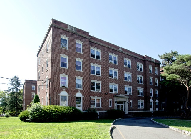


Property Detail
501 W 7Th St
12-00762-0000-00003
ADDITIONAL LOTS: 79184 SQ FT
Apartment
Union
R-4
New Jersey
B and X Area of moderate flood hazard, usually the area between the limits of the 100-year and 500-year floods.
3
2024
1.59 AC
2025
Western Union County
039600
Northern New Jersey
19,296 SF
Newark, NJ
NEARBY LISTINGS FOR SALE OR LEASE
DEMOGRAPHICS near 501 W 7Th St
1 mile
3 mile
5 mile
2025 Total Population
34,774
141,923
297,949
2030 Population
35,982
147,705
311,401
Pop Growth 2025-2030
+ 3.47%
+ 4.07%
+ 4.51%
Average Age
36
39
40
2025 Total Households
10,045
45,634
98,816
HH Growth 2025-2030
+ 3.58%
+ 4.23%
+ 4.69%
Median Household Inc
$73,554
$101,146
$126,309
Avg Household Size
3.30
3.00
2.90
2025 Avg HH Vehicles
1.00
2.00
2.00
Median Home Value
$426,255
$459,295
$577,629
Median Year Built
1949
1957
1964
Nearby Places
Map Layers
Map Styles
 Street
 Aerial
Layers
 Traffic
 Biking
Places
Listings with unknown addresses are not visible on the map
- Restaurants
- Banks
- Shops
- Fitness
- Groceries
PUBLIC TRANSPORTATION
TRANSIT/SUBWAY
Plainfield (Raritan Valley Line - NJ Transit Commuter Rail (NJ Transit))
Drive
Walk
Distance
Plainfield (Raritan Valley Line - NJ Transit Commuter Rail (NJ Transit))
3 min
16 min
0.8 mi
COMMUTER RAIL
Plainfield (Raritan Valley Line - NJ Transit Commuter Rail (NJ Transit))
Drive
Walk
Distance
Plainfield (Raritan Valley Line - NJ Transit Commuter Rail (NJ Transit))
2 min
16 min
0.8 mi
Netherwood (Raritan Valley Line - NJ Transit Commuter Rail (NJ Transit))
Drive
Walk
Distance
Netherwood (Raritan Valley Line - NJ Transit Commuter Rail (NJ Transit))
6 min
1.9 mi
AIRPORT
Newark Liberty International
Drive
Walk
Distance
Newark Liberty International
32 min
22.1 mi
Trenton Mercer
Drive
Walk
Distance
Trenton Mercer
61 min
41.0 mi
LaGuardia
Drive
Walk
Distance
LaGuardia
66 min
41.3 mi
Freight Ports
New York Container Terminal
Drive
Walk
Distance
New York Container Terminal
33 min
17.6 mi
SALE & LEASE HISTORY
LISTING DATE
SALE/LEASE

Feb 23, 2021
For Sale
Nearby Properties
Address
Land Use
TOTAL SIZE
Lot Size
Zoning
Address
Land Use
TOTAL SIZE
Lot Size
Zoning
17.01 AC
RM
Address
Land Use
TOTAL SIZE
Lot Size
Zoning
20.08 AC
RML1
Address
Land Use
TOTAL SIZE
Lot Size
Zoning
17.64 AC
R10A
Address
Land Use
TOTAL SIZE
Lot Size
Zoning
26.87 AC
H-D
Address
Land Use
TOTAL SIZE
Lot Size
Zoning
10.09 AC
Address
Land Use
TOTAL SIZE
Lot Size
Zoning
27.70 AC
Address
Land Use
TOTAL SIZE
Lot Size
Zoning
47.80 AC
H-D
Address
Land Use
TOTAL SIZE
Lot Size
Zoning
16.21 AC
RM
Address
Land Use
TOTAL SIZE
Lot Size
Zoning
233,217 SF
36.91 AC
LI5
Address
Land Use
TOTAL SIZE
Lot Size
Zoning
15.79 AC
H-D
Address
Land Use
TOTAL SIZE
Lot Size
Zoning
12.47 AC
H-D
Address
Land Use
TOTAL SIZE
Lot Size
Zoning
9.38 AC
RM
Address
Land Use
TOTAL SIZE
Lot Size
Zoning
19.84 AC
Address
Land Use
TOTAL SIZE
Lot Size
Zoning
9.85 AC
10A
Address
Land Use
TOTAL SIZE
Lot Size
Zoning
16.97 AC
Address
Land Use
TOTAL SIZE
Lot Size
Zoning
30.80 AC
R10
Address
Land Use
TOTAL SIZE
Lot Size
Zoning
4.74 AC
NC
Address
Land Use
TOTAL SIZE
Lot Size
Zoning
19.84 AC
H-D
Address
Land Use
TOTAL SIZE
Lot Size
Zoning
30.40 AC
PR
Address
Land Use
TOTAL SIZE
Lot Size
Zoning
19.19 AC
R-3
Address
Land Use
TOTAL SIZE
Lot Size
Zoning
21.53 AC
H-D
Address
Land Use
TOTAL SIZE
Lot Size
Zoning
80,262 SF
11.47 AC
ER
Address
Land Use
TOTAL SIZE
Lot Size
Zoning
122,820 SF
14.65 AC
H-D
Address
Land Use
TOTAL SIZE
Lot Size
Zoning
12.52 AC
H-D
Address
Land Use
TOTAL SIZE
Lot Size
Zoning
21.60 AC
M3
Address
Land Use
TOTAL SIZE
Lot Size
Zoning
11.20 AC
Address
Land Use
TOTAL SIZE
Lot Size
Zoning
0.39 AC
R5
Address
Land Use
TOTAL SIZE
Lot Size
Zoning
11.02 AC
Address
Land Use
TOTAL SIZE
Lot Size
Zoning
12.06 AC
Address
Land Use
TOTAL SIZE
Lot Size
Zoning
The World's #1 Commercial Real Estate Marketplace
Connect with us
© 2026 CoStar Group
The information above has been obtained from sources believed reliable. While we do not doubt its accuracy we have not verified it and make no guarantee, warranty or representation about it. It is your responsibility to independently confirm its accuracy and completeness. Any projections, opinions, assumptions, or estimates used are for example only and do not represent the current or future performance of the property. The value of this transaction to you depends on tax and other factors which should be evaluated by your tax, financial, and legal advisors. You and your advisors should conduct a careful, independent investigation of the property to determine to your satisfaction the suitability of the property for your needs.