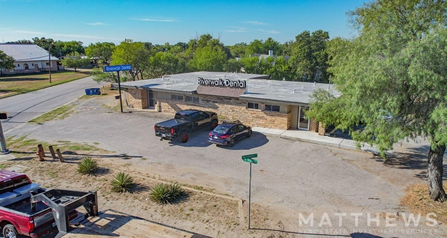
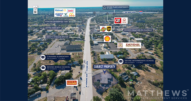
Property Record
501 W Hondo Ave, Devine, TX 78016

Save to a Folder
{{folder.Name}}
{{folder.ListingIds.length}} Properties
{{folder.ListingIds.length}} Property
Create a New Folder
Property Detail
501 W Hondo Ave
San Antonio-New Braunfels, TX
DEVINE BLOCK 77 LOT 4 EAST PART OF; ACRES .394
14903
Medina
Commercialnec
Texas
C and X Area of minimal flood hazard, usually depicted on FIRMs as above the 500-year flood level.
4
2025
0.39 AC
2025
Medina County
000801
San Antonio
3,363 SF
NEARBY LISTINGS FOR SALE OR LEASE
DEMOGRAPHICS near 501 W Hondo Ave
1 mile
3 mile
5 mile
2025 Total Population
3,659
7,381
11,117
2030 Population
3,935
7,916
11,864
Pop Growth 2025-2030
+ 7.54%
+ 7.25%
+ 6.72%
Average Age
39
40
40
2025 Total Households
1,274
2,585
3,858
HH Growth 2025-2030
+ 7.77%
+ 7.47%
+ 6.95%
Median Household Inc
$31,571
$49,499
$54,073
Avg Household Size
2.70
2.70
2.80
2025 Avg HH Vehicles
2.00
2.00
2.00
Median Home Value
$181,034
$194,359
$192,635
Median Year Built
1978
1980
1982
Nearby Places
Map Layers
Map Styles
 Street
 Aerial
Layers
 Traffic
 Biking
Places
Listings with unknown addresses are not visible on the map
- Restaurants
- Banks
- Shops
- Fitness
- Groceries
PUBLIC TRANSPORTATION
AIRPORT
San Antonio International
Drive
Walk
Distance
San Antonio International
51 min
41.8 mi
SALE & LEASE HISTORY
LISTING DATE
SALE/LEASE

Oct 29, 2024
For Sale
Nearby Properties
Address
Land Use
TOTAL SIZE
Lot Size
Zoning
Address
Land Use
TOTAL SIZE
Lot Size
Zoning
121,327 SF
14.30 AC
Address
Land Use
TOTAL SIZE
Lot Size
Zoning
299,203 SF
8.15 AC
Address
Land Use
TOTAL SIZE
Lot Size
Zoning
34,315 SF
3.37 AC
Address
Land Use
TOTAL SIZE
Lot Size
Zoning
363,024 SF
8 AC
Address
Land Use
TOTAL SIZE
Lot Size
Zoning
13,734 SF
6 AC
Address
Land Use
TOTAL SIZE
Lot Size
Zoning
39,472 SF
3.54 AC
Address
Land Use
TOTAL SIZE
Lot Size
Zoning
32,722 SF
2.85 AC
Address
Land Use
TOTAL SIZE
Lot Size
Zoning
7,472 SF
2.22 AC
Address
Land Use
TOTAL SIZE
Lot Size
Zoning
16,628 SF
2.16 AC
Address
Land Use
TOTAL SIZE
Lot Size
Zoning
5,966 SF
2.12 AC
Address
Land Use
TOTAL SIZE
Lot Size
Zoning
10,652 SF
1.10 AC
Address
Land Use
TOTAL SIZE
Lot Size
Zoning
4,800 SF
2.50 AC
Address
Land Use
TOTAL SIZE
Lot Size
Zoning
12,448 SF
1.96 AC
Address
Land Use
TOTAL SIZE
Lot Size
Zoning
13,096 SF
7.14 AC
Address
Land Use
TOTAL SIZE
Lot Size
Zoning
12,264 SF
1.94 AC
Address
Land Use
TOTAL SIZE
Lot Size
Zoning
8,352 SF
2.01 AC
Address
Land Use
TOTAL SIZE
Lot Size
Zoning
7,752 SF
0.98 AC
Address
Land Use
TOTAL SIZE
Lot Size
Zoning
17,210 SF
12.22 AC
Address
Land Use
TOTAL SIZE
Lot Size
Zoning
13,700 SF
6 AC
Address
Land Use
TOTAL SIZE
Lot Size
Zoning
14,056 SF
66.14 AC
Address
Land Use
TOTAL SIZE
Lot Size
Zoning
4,878 SF
1.49 AC
Address
Land Use
TOTAL SIZE
Lot Size
Zoning
11,938 SF
8.90 AC
Address
Land Use
TOTAL SIZE
Lot Size
Zoning
12,890 SF
5 AC
Address
Land Use
TOTAL SIZE
Lot Size
Zoning
185,627 SF
7.36 AC
Address
Land Use
TOTAL SIZE
Lot Size
Zoning
5,558 SF
1.23 AC
Address
Land Use
TOTAL SIZE
Lot Size
Zoning
11,360 SF
8.42 AC
Address
Land Use
TOTAL SIZE
Lot Size
Zoning
18,750 SF
0.93 AC
Address
Land Use
TOTAL SIZE
Lot Size
Zoning
14,134 SF
2.50 AC
Address
Land Use
TOTAL SIZE
Lot Size
Zoning
1,596 SF
1.55 AC
Address
Land Use
TOTAL SIZE
Lot Size
Zoning
99.80 AC
The World's #1 Commercial Real Estate Marketplace
Connect with us
© 2026 CoStar Group
The information above has been obtained from sources believed reliable. While we do not doubt its accuracy we have not verified it and make no guarantee, warranty or representation about it. It is your responsibility to independently confirm its accuracy and completeness. Any projections, opinions, assumptions, or estimates used are for example only and do not represent the current or future performance of the property. The value of this transaction to you depends on tax and other factors which should be evaluated by your tax, financial, and legal advisors. You and your advisors should conduct a careful, independent investigation of the property to determine to your satisfaction the suitability of the property for your needs.