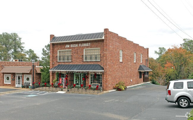
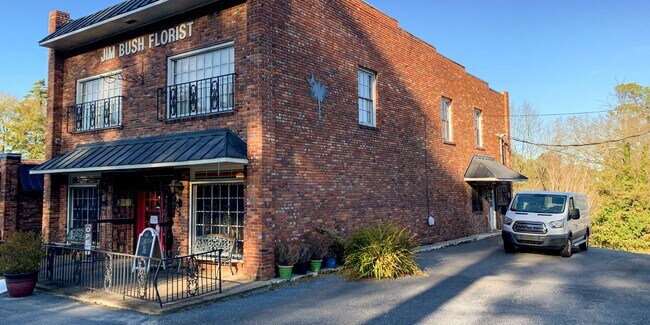
Property Record
501 W Martintown Rd, North Augusta, SC 29841
NEARBY LISTINGS FOR SALE OR LEASE
Property Detail
501 W Martintown Rd
Augusta-Richmond County, GA-SC
Ridge
006-18-01-008
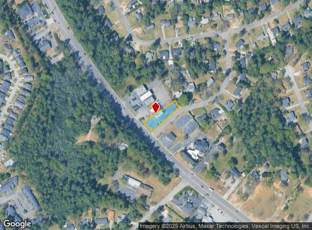
PARTRIDGE LANE & MARTINTOWN RD
Officebuilding
Aiken
X
South Carolina
13245C0040G
013
2025
0.37 AC
2025
North Augusta
020702
Augusta/Richmond County
4,966 SF
DEMOGRAPHICS near 501 W Martintown Rd
1 Mile
3 Mile
5 Mile
2024 Total Population
6,373
42,097
102,144
2029 Population
6,779
44,231
105,343
Pop Growth 2024-2029
+ 6.37%
+ 5.07%
+ 3.13%
Average Age
43
41
40
2024 Total Households
2,858
18,654
45,027
HH Growth 2024-2029
+ 6.30%
+ 4.74%
+ 2.83%
Median Household Inc
$66,541
$53,858
$51,772
Avg Household Size
2.20
2.20
2.20
2024 Avg HH Vehicles
2.00
2.00
2.00
Median Home Value
$195,920
$178,104
$180,430
Median Year Built
1969
1970
1972
Nearby Places
Map Layers
Map Styles
 Street
 Aerial
- Restaurants
- Banks
- Shops
- Fitness
- Groceries
PUBLIC TRANSPORTATION
AIRPORT
Augusta Regional at Bush Field
DRIVE
WALK
Distance
Augusta Regional at Bush Field
25 min
11.6 mi
Freight Ports
Georgia Ports - Savannah
DRIVE
WALK
Distance
Georgia Ports - Savannah
163 min
123.6 mi
SALE & LEASE HISTORY
LISTING DATE
SALE/LEASE

Jan 27, 2022
For Sale
Nearby Properties
Address
Land Use
TOTAL SIZE
Lot Size
Zoning
Address
Land Use
TOTAL SIZE
Lot Size
Zoning
954,084 SF
18.30 AC
B-2
Address
Land Use
TOTAL SIZE
Lot Size
Zoning
8,993 SF
351.84 AC
R-1_B-2
Address
Land Use
TOTAL SIZE
Lot Size
Zoning
52,025 SF
6.46 AC
Address
Land Use
TOTAL SIZE
Lot Size
Zoning
627,990 SF
20 AC
P-1
Address
Land Use
TOTAL SIZE
Lot Size
Zoning
197,726 SF
2.93 AC
B-2
Address
Land Use
TOTAL SIZE
Lot Size
Zoning
169,662 SF
3.09 AC
B-2
Address
Land Use
TOTAL SIZE
Lot Size
Zoning
4,214 SF
12.73 AC
LI_B-2
Address
Land Use
TOTAL SIZE
Lot Size
Zoning
6,694 SF
17.75 AC
R-3B
Address
Land Use
TOTAL SIZE
Lot Size
Zoning
179,743 SF
9.52 AC
007
Address
Land Use
TOTAL SIZE
Lot Size
Zoning
33,784 SF
22.27 AC
B-2
Address
Land Use
TOTAL SIZE
Lot Size
Zoning
6,516 SF
15.33 AC
R-3B
Address
Land Use
TOTAL SIZE
Lot Size
Zoning
179,779 SF
5.91 AC
B-2
Address
Land Use
TOTAL SIZE
Lot Size
Zoning
109,272 SF
16.16 AC
Address
Land Use
TOTAL SIZE
Lot Size
Zoning
Address
Land Use
TOTAL SIZE
Lot Size
Zoning
1,000 SF
4.45 AC
Address
Land Use
TOTAL SIZE
Lot Size
Zoning
3,447 SF
16.67 AC
R-3B
Address
Land Use
TOTAL SIZE
Lot Size
Zoning
267,960 SF
2.13 AC
B-2
Address
Land Use
TOTAL SIZE
Lot Size
Zoning
61,769 SF
12.06 AC
B-2
Address
Land Use
TOTAL SIZE
Lot Size
Zoning
152,352 SF
1.51 AC
Address
Land Use
TOTAL SIZE
Lot Size
Zoning
137,062 SF
4.45 AC
B-2
Address
Land Use
TOTAL SIZE
Lot Size
Zoning
127,728 SF
1.34 AC
B-2
Address
Land Use
TOTAL SIZE
Lot Size
Zoning
109,076 SF
4.23 AC
R-3C
Address
Land Use
TOTAL SIZE
Lot Size
Zoning
106,500 SF
1.41 AC
Address
Land Use
TOTAL SIZE
Lot Size
Zoning
25,504 SF
9.87 AC
B-2
Address
Land Use
TOTAL SIZE
Lot Size
Zoning
21,615 SF
207.78 AC
R-1
Address
Land Use
TOTAL SIZE
Lot Size
Zoning
225,546 SF
1.28 AC
B-2
Address
Land Use
TOTAL SIZE
Lot Size
Zoning
6,424 SF
15.16 AC
R-3C
Address
Land Use
TOTAL SIZE
Lot Size
Zoning
87,453 SF
8.90 AC
Address
Land Use
TOTAL SIZE
Lot Size
Zoning
431,971 SF
21.07 AC
007
Address
Land Use
TOTAL SIZE
Lot Size
Zoning
17,954 SF
6.61 AC
LI
The World's #1 Commercial Real Estate Marketplace
Connect with us
© 2025 CoStar Group
The information above has been obtained from sources believed reliable. While we do not doubt its accuracy we have not verified it and make no guarantee, warranty or representation about it. It is your responsibility to independently confirm its accuracy and completeness. Any projections, opinions, assumptions, or estimates used are for example only and do not represent the current or future performance of the property. The value of this transaction to you depends on tax and other factors which should be evaluated by your tax, financial, and legal advisors. You and your advisors should conduct a careful, independent investigation of the property to determine to your satisfaction the suitability of the property for your needs.