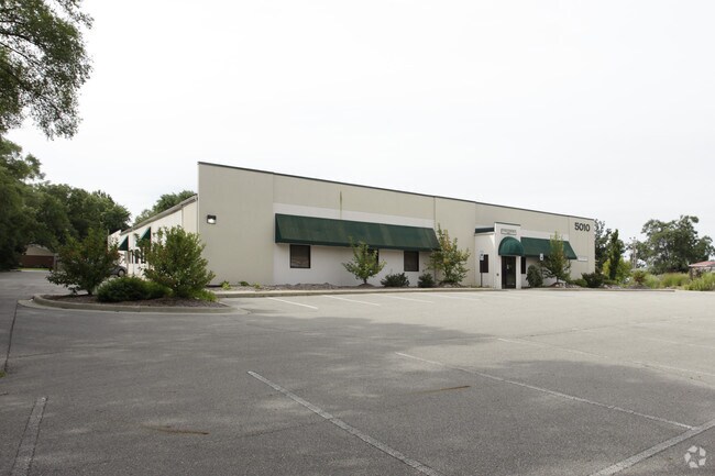
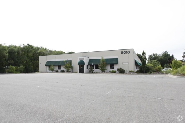
Property Record
5010 Gull Rd, Kalamazoo, MI 49048
Property Detail
5010 Gull Rd
07-06-355-037
UNIT A, GULL ROAD 5010 OFFICE CONDOMINIUM KALAMAZOO COUNTY SUBDIVISION PLAN 231
Officecondo
Kalamazoo
B-2
Michigan
B and X Area of moderate flood hazard, usually the area between the limits of the 100-year and 500-year floods.
2.11 AC
2025
NE Kalamazoo County
2025
West Michigan
002204
Kalamazoo-Portage, MI
5,964 SF
NEARBY LISTINGS FOR SALE OR LEASE
DEMOGRAPHICS near 5010 Gull Rd
1 mile
3 mile
5 mile
2025 Total Population
4,589
32,280
87,658
2030 Population
4,538
32,206
89,164
Pop Growth 2025-2030
(1.11%)
(0.23%)
+ 1.72%
Average Age
39
39
37
2025 Total Households
2,165
13,277
35,929
HH Growth 2025-2030
(1.25%)
(0.47%)
+ 1.94%
Median Household Inc
$52,350
$62,104
$58,868
Avg Household Size
2.10
2.30
2.30
2025 Avg HH Vehicles
1.00
2.00
2.00
Median Home Value
$159,459
$168,913
$179,700
Median Year Built
1973
1961
1959
Nearby Places
Map Layers
Map Styles
 Street
 Aerial
Layers
 Traffic
 Biking
Places
Listings with unknown addresses are not visible on the map
- Restaurants
- Banks
- Shops
- Fitness
- Groceries
PUBLIC TRANSPORTATION
COMMUTER RAIL
Kalamazoo (Blue Water - Amtrak, Wolverine - Amtrak)
Drive
Walk
Distance
Kalamazoo (Blue Water - Amtrak, Wolverine - Amtrak)
7 min
3.4 mi
AIRPORT
Kalamazoo/Battle Creek International
Drive
Walk
Distance
Kalamazoo/Battle Creek International
18 min
7.3 mi
Freight Ports
Port of Toledo
Drive
Walk
Distance
Port of Toledo
177 min
145.1 mi
Nearby Properties
Address
Land Use
TOTAL SIZE
Lot Size
Zoning
Address
Land Use
TOTAL SIZE
Lot Size
Zoning
877,422 SF
38.18 AC
M-2
Address
Land Use
TOTAL SIZE
Lot Size
Zoning
20.94 AC
Address
Land Use
TOTAL SIZE
Lot Size
Zoning
390,900 SF
14 AC
I-M IND
Address
Land Use
TOTAL SIZE
Lot Size
Zoning
185,107 SF
25.12 AC
RM
Address
Land Use
TOTAL SIZE
Lot Size
Zoning
196,221 SF
26.26 AC
RM
Address
Land Use
TOTAL SIZE
Lot Size
Zoning
185,092 SF
26.86 AC
RM
Address
Land Use
TOTAL SIZE
Lot Size
Zoning
12.58 AC
Address
Land Use
TOTAL SIZE
Lot Size
Zoning
274,412 SF
12.10 AC
RM-1
Address
Land Use
TOTAL SIZE
Lot Size
Zoning
226,051 SF
44.98 AC
B-2
Address
Land Use
TOTAL SIZE
Lot Size
Zoning
217,600 SF
21.30 AC
N/A
Address
Land Use
TOTAL SIZE
Lot Size
Zoning
133,600 SF
15.08 AC
B-1
Address
Land Use
TOTAL SIZE
Lot Size
Zoning
193,194 SF
23.96 AC
B-3
Address
Land Use
TOTAL SIZE
Lot Size
Zoning
99,017 SF
9.42 AC
RM
Address
Land Use
TOTAL SIZE
Lot Size
Zoning
185,528 SF
17.20 AC
R5
Address
Land Use
TOTAL SIZE
Lot Size
Zoning
98,360 SF
13.58 AC
R4
Address
Land Use
TOTAL SIZE
Lot Size
Zoning
143,760 SF
10.25 AC
M-2
Address
Land Use
TOTAL SIZE
Lot Size
Zoning
118,104 SF
10.40 AC
R4
Address
Land Use
TOTAL SIZE
Lot Size
Zoning
9.65 AC
RM-36
Address
Land Use
TOTAL SIZE
Lot Size
Zoning
49,216 SF
2.90 AC
RM-2
Address
Land Use
TOTAL SIZE
Lot Size
Zoning
673,310 SF
29.33 AC
A-H
Address
Land Use
TOTAL SIZE
Lot Size
Zoning
8,214 SF
2.39 AC
C-3 GEN
Address
Land Use
TOTAL SIZE
Lot Size
Zoning
155,756 SF
0.67 AC
RM-2
Address
Land Use
TOTAL SIZE
Lot Size
Zoning
236,922 SF
13.32 AC
M-2
Address
Land Use
TOTAL SIZE
Lot Size
Zoning
102,300 SF
10.12 AC
B-1
Address
Land Use
TOTAL SIZE
Lot Size
Zoning
84,360 SF
5.31 AC
R4
Address
Land Use
TOTAL SIZE
Lot Size
Zoning
53,003 SF
3.20 AC
RM-36
Address
Land Use
TOTAL SIZE
Lot Size
Zoning
112,736 SF
15.84 AC
R-1C
Address
Land Use
TOTAL SIZE
Lot Size
Zoning
109,892 SF
12.24 AC
RM-1
Address
Land Use
TOTAL SIZE
Lot Size
Zoning
2,164 SF
3.48 AC
B-2
Address
Land Use
TOTAL SIZE
Lot Size
Zoning
42,649 SF
3.22 AC
CN-1
The World's #1 Commercial Real Estate Marketplace
Connect with us
© 2026 CoStar Group
The information above has been obtained from sources believed reliable. While we do not doubt its accuracy we have not verified it and make no guarantee, warranty or representation about it. It is your responsibility to independently confirm its accuracy and completeness. Any projections, opinions, assumptions, or estimates used are for example only and do not represent the current or future performance of the property. The value of this transaction to you depends on tax and other factors which should be evaluated by your tax, financial, and legal advisors. You and your advisors should conduct a careful, independent investigation of the property to determine to your satisfaction the suitability of the property for your needs.