Property Record
5010 Manchester Rd, New Franklin, OH 44319
NEARBY LISTINGS FOR SALE OR LEASE
Property Detail
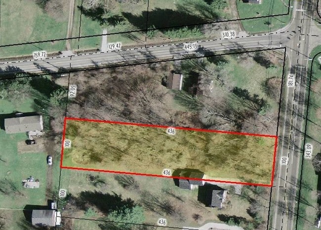
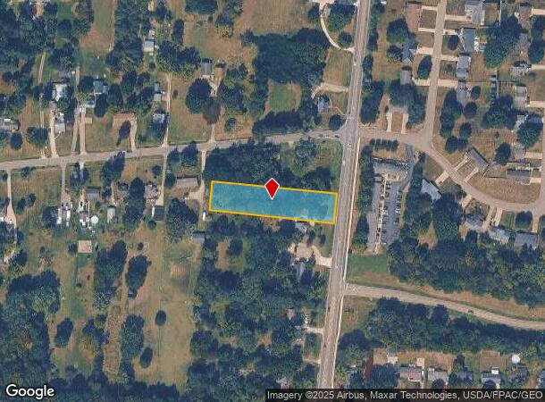
5010 Manchester Rd
Akron, OH
Mason Farm
23-02657
TR 14 LOT NW SUB 9 MASON FARM ACRES MANCHESTER RD 1.000A
Residentialacreage
Summit
X
Ohio
39153C0254E
nw
2023
0.93 AC
2025
Akron
531702
Cleveland
DEMOGRAPHICS near 5010 Manchester Rd
1 Mile
3 Mile
5 Mile
2024 Total Population
2,438
21,580
75,516
2029 Population
2,396
21,309
74,650
Pop Growth 2024-2029
(1.72%)
(1.26%)
(1.15%)
Average Age
45
45
43
2024 Total Households
989
9,261
32,434
HH Growth 2024-2029
(1.62%)
(1.23%)
(1.16%)
Median Household Inc
$69,745
$77,217
$60,489
Avg Household Size
2.40
2.30
2.30
2024 Avg HH Vehicles
2.00
2.00
2.00
Median Home Value
$172,385
$194,790
$160,387
Median Year Built
1962
1966
1961
Nearby Places
Map Layers
Map Styles
 Street
 Aerial
- Restaurants
- Banks
- Shops
- Fitness
- Groceries
PUBLIC TRANSPORTATION
COMMUTER RAIL
Akron Northside (National Park Scenic Railway - Cuyahoga Valley Scenic Railroad)
DRIVE
WALK
Distance
Akron Northside (National Park Scenic Railway - Cuyahoga Valley Scenic Railroad)
20 min
9.6 mi
AIRPORT
Akron-Canton Regional
DRIVE
WALK
Distance
Akron-Canton Regional
19 min
11.5 mi
Freight Ports
Port of Toledo
DRIVE
WALK
Distance
Port of Toledo
170 min
141.2 mi
Nearby Properties
Address
Land Use
TOTAL SIZE
Lot Size
Zoning
Address
Land Use
TOTAL SIZE
Lot Size
Zoning
Address
Land Use
TOTAL SIZE
Lot Size
Zoning
91,678 SF
5.24 AC
Address
Land Use
TOTAL SIZE
Lot Size
Zoning
1,049.17 AC
Address
Land Use
TOTAL SIZE
Lot Size
Zoning
Address
Land Use
TOTAL SIZE
Lot Size
Zoning
Address
Land Use
TOTAL SIZE
Lot Size
Zoning
Address
Land Use
TOTAL SIZE
Lot Size
Zoning
24,812 SF
29.15 AC
Address
Land Use
TOTAL SIZE
Lot Size
Zoning
Address
Land Use
TOTAL SIZE
Lot Size
Zoning
Address
Land Use
TOTAL SIZE
Lot Size
Zoning
136,491 SF
35.31 AC
Address
Land Use
TOTAL SIZE
Lot Size
Zoning
Address
Land Use
TOTAL SIZE
Lot Size
Zoning
Address
Land Use
TOTAL SIZE
Lot Size
Zoning
Address
Land Use
TOTAL SIZE
Lot Size
Zoning
4,800 SF
493 AC
Address
Land Use
TOTAL SIZE
Lot Size
Zoning
Address
Land Use
TOTAL SIZE
Lot Size
Zoning
70,783 SF
15.97 AC
Address
Land Use
TOTAL SIZE
Lot Size
Zoning
47,384 SF
30.16 AC
Address
Land Use
TOTAL SIZE
Lot Size
Zoning
62,000 SF
6.91 AC
Address
Land Use
TOTAL SIZE
Lot Size
Zoning
Address
Land Use
TOTAL SIZE
Lot Size
Zoning
Address
Land Use
TOTAL SIZE
Lot Size
Zoning
99,408 SF
7.63 AC
Address
Land Use
TOTAL SIZE
Lot Size
Zoning
Address
Land Use
TOTAL SIZE
Lot Size
Zoning
16,346 SF
12.13 AC
Address
Land Use
TOTAL SIZE
Lot Size
Zoning
38,078 SF
6.15 AC
Address
Land Use
TOTAL SIZE
Lot Size
Zoning
39,266 SF
21.17 AC
Address
Land Use
TOTAL SIZE
Lot Size
Zoning
106,300 SF
10.19 AC
Address
Land Use
TOTAL SIZE
Lot Size
Zoning
42,548 SF
2.29 AC
Address
Land Use
TOTAL SIZE
Lot Size
Zoning
Address
Land Use
TOTAL SIZE
Lot Size
Zoning
39,758 SF
5.01 AC
Address
Land Use
TOTAL SIZE
Lot Size
Zoning
78,543 SF
6.34 AC
The World's #1 Commercial Real Estate Marketplace
Connect with us
© 2025 CoStar Group
The information above has been obtained from sources believed reliable. While we do not doubt its accuracy we have not verified it and make no guarantee, warranty or representation about it. It is your responsibility to independently confirm its accuracy and completeness. Any projections, opinions, assumptions, or estimates used are for example only and do not represent the current or future performance of the property. The value of this transaction to you depends on tax and other factors which should be evaluated by your tax, financial, and legal advisors. You and your advisors should conduct a careful, independent investigation of the property to determine to your satisfaction the suitability of the property for your needs.