Property Record
5011 Navarre Ave, Oregon, OH 43616
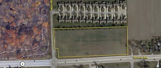
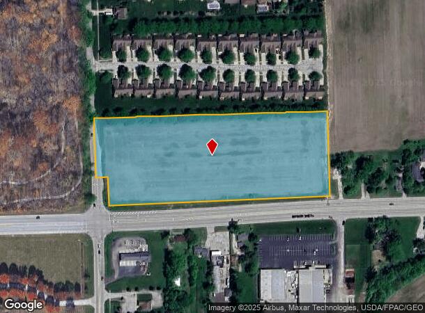
This Property Is For Sale
NEARBY LISTINGS FOR SALE OR LEASE
Property Detail
5011 Navarre Ave
Toledo, OH
Lucas
44-15857
Ohio
Sfr
8.10 AC
X
East Toledo/Oregon
39095C0120F
Toledo
DEMOGRAPHICS near 5011 Navarre Ave
1 Mile
3 Mile
5 Mile
2024 Total Population
1,595
15,359
56,688
2029 Population
1,574
15,045
56,297
Pop Growth 2024-2029
(1.32%)
(2.04%)
(0.69%)
Average Age
46
44
40
2024 Total Households
672
6,390
22,745
HH Growth 2024-2029
(1.19%)
(2.16%)
(0.76%)
Median Household Inc
$97,678
$73,709
$48,734
Avg Household Size
2.30
2.30
2.30
2024 Avg HH Vehicles
2.00
2.00
2.00
Median Home Value
$234,977
$192,819
$138,328
Median Year Built
1992
1974
1958
Nearby Places
Map Layers
Map Styles
 Street
 Aerial
- Restaurants
- Banks
- Shops
- Fitness
- Groceries
PUBLIC TRANSPORTATION
COMMUTER RAIL
Toledo (Capitol Limited - Amtrak, Lake Shore Limited - Amtrak)
DRIVE
WALK
Distance
Toledo (Capitol Limited - Amtrak, Lake Shore Limited - Amtrak)
11 min
6.6 mi
AIRPORT
Eugene F Kranz Toledo Express
DRIVE
WALK
Distance
Eugene F Kranz Toledo Express
42 min
24.7 mi
Freight Ports
Port of Toledo
DRIVE
WALK
Distance
Port of Toledo
15 min
6.2 mi
Nearby Properties
Address
Land Use
TOTAL SIZE
Lot Size
Zoning
Address
Land Use
TOTAL SIZE
Lot Size
Zoning
311,537 SF
35.14 AC
40-R1
Address
Land Use
TOTAL SIZE
Lot Size
Zoning
73,802 SF
22.50 AC
40-R1
Address
Land Use
TOTAL SIZE
Lot Size
Zoning
22.93 AC
40-R3
Address
Land Use
TOTAL SIZE
Lot Size
Zoning
214,312 SF
35.35 AC
40-C5
Address
Land Use
TOTAL SIZE
Lot Size
Zoning
27.41 AC
40-CI
Address
Land Use
TOTAL SIZE
Lot Size
Zoning
102,535 SF
20 AC
40-R2
Address
Land Use
TOTAL SIZE
Lot Size
Zoning
34 AC
40-C5
Address
Land Use
TOTAL SIZE
Lot Size
Zoning
150,000 SF
17.55 AC
40-CI
Address
Land Use
TOTAL SIZE
Lot Size
Zoning
181,347 SF
14.12 AC
40-R4
Address
Land Use
TOTAL SIZE
Lot Size
Zoning
187,988 SF
20 AC
40-M2
Address
Land Use
TOTAL SIZE
Lot Size
Zoning
29.92 AC
40-CI
Address
Land Use
TOTAL SIZE
Lot Size
Zoning
117,094 SF
28.04 AC
40-R2
Address
Land Use
TOTAL SIZE
Lot Size
Zoning
77,079 SF
3.87 AC
40-R3
Address
Land Use
TOTAL SIZE
Lot Size
Zoning
55,544 SF
13 AC
40-R2
Address
Land Use
TOTAL SIZE
Lot Size
Zoning
91,261 SF
5.47 AC
40-C2
Address
Land Use
TOTAL SIZE
Lot Size
Zoning
58,281 SF
2.60 AC
40-C2
Address
Land Use
TOTAL SIZE
Lot Size
Zoning
46,267 SF
3.22 AC
40-R3
Address
Land Use
TOTAL SIZE
Lot Size
Zoning
69,259 SF
13.65 AC
40-R2
Address
Land Use
TOTAL SIZE
Lot Size
Zoning
93,191 SF
11.13 AC
40-C4
Address
Land Use
TOTAL SIZE
Lot Size
Zoning
104,012 SF
7.14 AC
40-R3
Address
Land Use
TOTAL SIZE
Lot Size
Zoning
47,907 SF
10.24 AC
40-A1
Address
Land Use
TOTAL SIZE
Lot Size
Zoning
66,701 SF
4 AC
40-R3
Address
Land Use
TOTAL SIZE
Lot Size
Zoning
42,888 SF
3.99 AC
40-C5
Address
Land Use
TOTAL SIZE
Lot Size
Zoning
61,921 SF
48.79 AC
40-M2
Address
Land Use
TOTAL SIZE
Lot Size
Zoning
59,212 SF
3.02 AC
40-C2
Address
Land Use
TOTAL SIZE
Lot Size
Zoning
77,884 SF
6.22 AC
40-R3
Address
Land Use
TOTAL SIZE
Lot Size
Zoning
9 AC
40-R4
Address
Land Use
TOTAL SIZE
Lot Size
Zoning
3.02 AC
40-R2
Address
Land Use
TOTAL SIZE
Lot Size
Zoning
118,460 SF
7.75 AC
40-R4
Address
Land Use
TOTAL SIZE
Lot Size
Zoning
48,156 SF
1.30 AC
40-C4
The World's #1 Commercial Real Estate Marketplace
Connect with us
© 2026 CoStar Group
The information above has been obtained from sources believed reliable. While we do not doubt its accuracy we have not verified it and make no guarantee, warranty or representation about it. It is your responsibility to independently confirm its accuracy and completeness. Any projections, opinions, assumptions, or estimates used are for example only and do not represent the current or future performance of the property. The value of this transaction to you depends on tax and other factors which should be evaluated by your tax, financial, and legal advisors. You and your advisors should conduct a careful, independent investigation of the property to determine to your satisfaction the suitability of the property for your needs.