Property Record
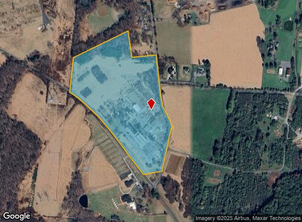
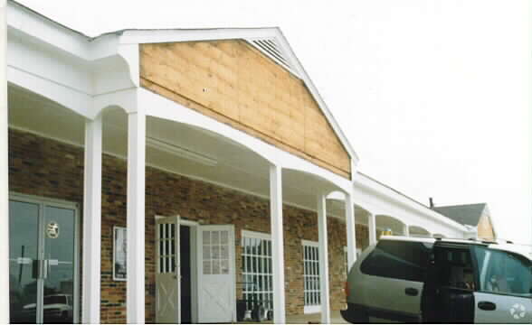
5011 Olney Laytonsville Rd, Olney, MD 20832


NEARBY LISTINGS FOR SALE OR LEASE
-
-
View all Olney listings for sale on LoopNet.com
Property Detail
5011 Olney Laytonsville Rd
08-00703485
Turkey Thicket Etc
Farms
SPRING GARDENS
X
Montgomery
24031C0215D
Maryland
2024
28.34 AC
2025
Outlying Montgmery Cnty E
701307
Washington, DC
3,111 SF
Washington-Arlington-Alexandria, DC-VA-MD-WV
DEMOGRAPHICS near 5011 Olney Laytonsville Rd
1 Mile
3 Mile
5 Mile
2024 Total Population
915
31,005
97,580
2029 Population
885
30,360
96,068
Pop Growth 2024-2029
(3.28%)
(2.08%)
(1.55%)
Average Age
41
42
41
2024 Total Households
294
10,291
32,008
HH Growth 2024-2029
(3.40%)
(2.29%)
(1.73%)
Median Household Inc
$176,415
$158,095
$134,479
Avg Household Size
3.00
2.90
3.00
2024 Avg HH Vehicles
2.00
2.00
2.00
Median Home Value
$733,750
$669,297
$583,492
Median Year Built
1994
1985
1984
Nearby Places
Map Layers
Map Styles
 Street
 Aerial
- Restaurants
- Banks
- Shops
- Fitness
- Groceries
PUBLIC TRANSPORTATION
COMMUTER RAIL
Washington Grove (BRUNSWICK - WASHINGTON - Maryland Area Regional Commuter Trains (The MARC), Brunswick Line - Maryland Area Regional Commuter Trains (The MARC))
DRIVE
WALK
Distance
Washington Grove (BRUNSWICK - WASHINGTON - Maryland Area Regional Commuter Trains (The MARC), Brunswick Line - Maryland Area Regional Commuter Trains (The MARC))
16 min
7.6 mi
Gaithersburg (Brunswick Line - Maryland Area Regional Commuter Trains (The MARC))
DRIVE
WALK
Distance
Gaithersburg (Brunswick Line - Maryland Area Regional Commuter Trains (The MARC))
17 min
8.4 mi
AIRPORT
Ronald Reagan Washington Ntl
DRIVE
WALK
Distance
Ronald Reagan Washington Ntl
50 min
26.5 mi
Baltimore/Washington International Thurgood Marshall
DRIVE
WALK
Distance
Baltimore/Washington International Thurgood Marshall
48 min
30.3 mi
Washington Dulles International
DRIVE
WALK
Distance
Washington Dulles International
63 min
37.8 mi
Freight Ports
Port of Baltimore
DRIVE
WALK
Distance
Port of Baltimore
52 min
33.1 mi
Nearby Properties
Address
Land Use
TOTAL SIZE
Lot Size
Zoning
Address
Land Use
TOTAL SIZE
Lot Size
Zoning
202,044 SF
17.69 AC
CRT2.
Address
Land Use
TOTAL SIZE
Lot Size
Zoning
96,941 SF
10.87 AC
CRT2.
Address
Land Use
TOTAL SIZE
Lot Size
Zoning
140,080 SF
6.48 AC
PD9
Address
Land Use
TOTAL SIZE
Lot Size
Zoning
161.53 AC
AR
Address
Land Use
TOTAL SIZE
Lot Size
Zoning
110,210 SF
3.92 AC
CRT2.
Address
Land Use
TOTAL SIZE
Lot Size
Zoning
118,980 SF
9.06 AC
IL1.0
Address
Land Use
TOTAL SIZE
Lot Size
Zoning
58,437 SF
3.55 AC
CRT2.
Address
Land Use
TOTAL SIZE
Lot Size
Zoning
35,885 SF
19.21 AC
RE1
Address
Land Use
TOTAL SIZE
Lot Size
Zoning
78,547 SF
29.77 AC
R90
Address
Land Use
TOTAL SIZE
Lot Size
Zoning
34,658 SF
2.99 AC
CRT2.
Address
Land Use
TOTAL SIZE
Lot Size
Zoning
65,000 SF
19.80 AC
RE1
Address
Land Use
TOTAL SIZE
Lot Size
Zoning
53,664 SF
17.63 AC
R90
Address
Land Use
TOTAL SIZE
Lot Size
Zoning
68,190 SF
3.29 AC
CRT2.
Address
Land Use
TOTAL SIZE
Lot Size
Zoning
47,870 SF
7.80 AC
R200
Address
Land Use
TOTAL SIZE
Lot Size
Zoning
84,948 SF
4.14 AC
IL1.0
Address
Land Use
TOTAL SIZE
Lot Size
Zoning
64,160 SF
1.39 AC
RE2
Address
Land Use
TOTAL SIZE
Lot Size
Zoning
90,759 SF
5.45 AC
RE2
Address
Land Use
TOTAL SIZE
Lot Size
Zoning
22.72 AC
RE1
Address
Land Use
TOTAL SIZE
Lot Size
Zoning
2,722 SF
35.21 AC
RE1
Address
Land Use
TOTAL SIZE
Lot Size
Zoning
89,400 SF
12.90 AC
RE1
Address
Land Use
TOTAL SIZE
Lot Size
Zoning
35,412 SF
4.64 AC
RE2
Address
Land Use
TOTAL SIZE
Lot Size
Zoning
39,787 SF
4.95 AC
CRT2.
Address
Land Use
TOTAL SIZE
Lot Size
Zoning
35.14 AC
AR
Address
Land Use
TOTAL SIZE
Lot Size
Zoning
45,840 SF
3.29 AC
IL1.0
Address
Land Use
TOTAL SIZE
Lot Size
Zoning
25,704 SF
3.83 AC
C1
Address
Land Use
TOTAL SIZE
Lot Size
Zoning
56,307 SF
2.89 AC
IM2.5
Address
Land Use
TOTAL SIZE
Lot Size
Zoning
36,000 SF
4.99 AC
IL1.0
Address
Land Use
TOTAL SIZE
Lot Size
Zoning
33,680 SF
2.05 AC
IL1.0
Address
Land Use
TOTAL SIZE
Lot Size
Zoning
26,764 SF
1.54 AC
CRT2.
Address
Land Use
TOTAL SIZE
Lot Size
Zoning
2.09 AC
CRT2.
The World's #1 Commercial Real Estate Marketplace
Connect with us
© 2026 CoStar Group
The information above has been obtained from sources believed reliable. While we do not doubt its accuracy we have not verified it and make no guarantee, warranty or representation about it. It is your responsibility to independently confirm its accuracy and completeness. Any projections, opinions, assumptions, or estimates used are for example only and do not represent the current or future performance of the property. The value of this transaction to you depends on tax and other factors which should be evaluated by your tax, financial, and legal advisors. You and your advisors should conduct a careful, independent investigation of the property to determine to your satisfaction the suitability of the property for your needs.