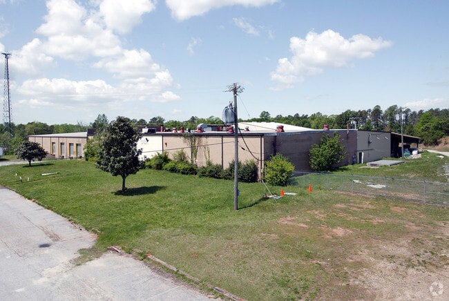
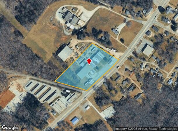
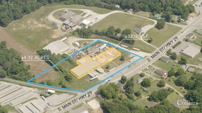
Property Record
5011 S Main St, Cowpens, SC 29330
NEARBY LISTINGS FOR SALE OR LEASE
Property Detail
5011 S Main St
3-14-00-315.01
Denero Textiles Llc
Commercialnec
TR A DENERO TEXTILES LLC SUR RD PB 59- 597 PB 94-468 PB 175-505-506
X
Spartanburg
45021C0150D
South Carolina
2024
4.32 AC
2025
Lower Spartanburg Cty
970102
Greenville/Spartanburg
32,165 SF
Spartanburg, SC
DEMOGRAPHICS near 5011 S Main St
1 Mile
3 Mile
5 Mile
2024 Total Population
1,803
8,560
23,457
2029 Population
2,017
9,516
26,067
Pop Growth 2024-2029
+ 11.87%
+ 11.17%
+ 11.13%
Average Age
41
41
42
2024 Total Households
753
3,475
9,776
HH Growth 2024-2029
+ 12.22%
+ 11.54%
+ 11.57%
Median Household Inc
$43,982
$56,232
$59,217
Avg Household Size
2.40
2.40
2.30
2024 Avg HH Vehicles
2.00
2.00
2.00
Median Home Value
$150,000
$157,982
$176,815
Median Year Built
1969
1976
1978
Nearby Places
Map Layers
Map Styles
 Street
 Aerial
- Restaurants
- Banks
- Shops
- Fitness
- Groceries
PUBLIC TRANSPORTATION
COMMUTER RAIL
Spartanburg Amtrak Station (Crescent - Amtrak)
DRIVE
WALK
Distance
Spartanburg Amtrak Station (Crescent - Amtrak)
16 min
8.6 mi
AIRPORT
Greenville Spartanburg International
DRIVE
WALK
Distance
Greenville Spartanburg International
42 min
30.9 mi
Freight Ports
North Charleston Terminal
DRIVE
WALK
Distance
North Charleston Terminal
236 min
202.2 mi
SALE & LEASE HISTORY
LISTING DATE
SALE/LEASE

Aug 25, 2020
For Sale
Nearby Properties
Address
Land Use
TOTAL SIZE
Lot Size
Zoning
Address
Land Use
TOTAL SIZE
Lot Size
Zoning
155,031 SF
12.58 AC
Address
Land Use
TOTAL SIZE
Lot Size
Zoning
17,150 SF
5 AC
Address
Land Use
TOTAL SIZE
Lot Size
Zoning
30.70 AC
Address
Land Use
TOTAL SIZE
Lot Size
Zoning
3,554 SF
5.38 AC
Address
Land Use
TOTAL SIZE
Lot Size
Zoning
3,300 SF
11.44 AC
Address
Land Use
TOTAL SIZE
Lot Size
Zoning
319,564 SF
39.43 AC
Address
Land Use
TOTAL SIZE
Lot Size
Zoning
2,748 SF
1.10 AC
Address
Land Use
TOTAL SIZE
Lot Size
Zoning
1,240 SF
4.10 AC
Address
Land Use
TOTAL SIZE
Lot Size
Zoning
6,513 SF
1.76 AC
Address
Land Use
TOTAL SIZE
Lot Size
Zoning
100,000 SF
7.45 AC
Address
Land Use
TOTAL SIZE
Lot Size
Zoning
2,283 SF
0.43 AC
Address
Land Use
TOTAL SIZE
Lot Size
Zoning
3,436 SF
0.62 AC
Address
Land Use
TOTAL SIZE
Lot Size
Zoning
3,688 SF
0.88 AC
Address
Land Use
TOTAL SIZE
Lot Size
Zoning
2,196 SF
0.99 AC
Address
Land Use
TOTAL SIZE
Lot Size
Zoning
2,400 SF
Address
Land Use
TOTAL SIZE
Lot Size
Zoning
21.54 AC
Address
Land Use
TOTAL SIZE
Lot Size
Zoning
1,767 SF
0.27 AC
Address
Land Use
TOTAL SIZE
Lot Size
Zoning
2,024 SF
3.66 AC
Address
Land Use
TOTAL SIZE
Lot Size
Zoning
1,912 SF
0.52 AC
Address
Land Use
TOTAL SIZE
Lot Size
Zoning
1,912 SF
0.32 AC
Address
Land Use
TOTAL SIZE
Lot Size
Zoning
5,130 SF
0.65 AC
Address
Land Use
TOTAL SIZE
Lot Size
Zoning
1,122 SF
0.63 AC
Address
Land Use
TOTAL SIZE
Lot Size
Zoning
1,764 SF
0.62 AC
Address
Land Use
TOTAL SIZE
Lot Size
Zoning
71.31 AC
Address
Land Use
TOTAL SIZE
Lot Size
Zoning
2,752 SF
2.95 AC
Address
Land Use
TOTAL SIZE
Lot Size
Zoning
2,310 SF
0.76 AC
Address
Land Use
TOTAL SIZE
Lot Size
Zoning
2,541 SF
0.59 AC
Address
Land Use
TOTAL SIZE
Lot Size
Zoning
11,154 SF
2.17 AC
Address
Land Use
TOTAL SIZE
Lot Size
Zoning
2,932 SF
1.75 AC
Address
Land Use
TOTAL SIZE
Lot Size
Zoning
1,650 SF
0.52 AC
The World's #1 Commercial Real Estate Marketplace
Connect with us
© 2025 CoStar Group
The information above has been obtained from sources believed reliable. While we do not doubt its accuracy we have not verified it and make no guarantee, warranty or representation about it. It is your responsibility to independently confirm its accuracy and completeness. Any projections, opinions, assumptions, or estimates used are for example only and do not represent the current or future performance of the property. The value of this transaction to you depends on tax and other factors which should be evaluated by your tax, financial, and legal advisors. You and your advisors should conduct a careful, independent investigation of the property to determine to your satisfaction the suitability of the property for your needs.