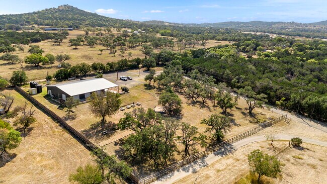
Property Record
50140 Interstate 10, Boerne, TX 78006
Property Detail
50140 Interstate 10
301907
A10470 - SURVEY 21 J P SMITH 3.082 ACRES
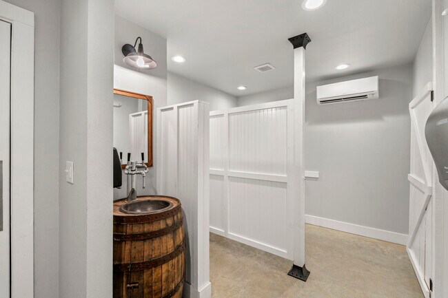
Commercialbuilding
KENDALL
B and X Area of moderate flood hazard, usually the area between the limits of the 100-year and 500-year floods.
Texas
2024
3.08 AC
2025
Kendall County
970100
San Antonio
4,220 SF
San Antonio-New Braunfels, TX
NEARBY LISTINGS FOR SALE OR LEASE
-
-
View all Boerne listings for lease on LoopNet.com
DEMOGRAPHICS near 50140 Interstate 10
1 mile
3 mile
5 mile
2025 Total Population
214
1,727
4,157
2030 Population
229
1,882
4,509
Pop Growth 2025-2030
+ 7.01%
+ 8.98%
+ 8.47%
Average Age
47
45
44
2025 Total Households
87
686
1,609
HH Growth 2025-2030
+ 6.90%
+ 8.89%
+ 8.58%
Median Household Inc
$74,463
$70,593
$73,002
Avg Household Size
2.40
2.40
2.50
2025 Avg HH Vehicles
2.00
2.00
2.00
Median Home Value
$671,428
$434,615
$369,303
Median Year Built
1977
1979
1987
Nearby Places
Map Layers
Map Styles
 Street
 Aerial
Layers
 Traffic
 Biking
Places
Listings with unknown addresses are not visible on the map
- Restaurants
- Banks
- Shops
- Fitness
- Groceries
PUBLIC TRANSPORTATION
AIRPORT
San Antonio International
Drive
Walk
Distance
San Antonio International
50 min
42.4 mi
SALE & LEASE HISTORY
LISTING DATE
SALE/LEASE

Oct 16, 2024
For Lease
Nearby Properties
Address
Land Use
TOTAL SIZE
Lot Size
Zoning
Address
Land Use
TOTAL SIZE
Lot Size
Zoning
15,156 SF
11.40 AC
Address
Land Use
TOTAL SIZE
Lot Size
Zoning
21,564 SF
6.02 AC
Address
Land Use
TOTAL SIZE
Lot Size
Zoning
16,662 SF
16.73 AC
Address
Land Use
TOTAL SIZE
Lot Size
Zoning
3,200 SF
3 AC
Address
Land Use
TOTAL SIZE
Lot Size
Zoning
15,834 SF
3 AC
Address
Land Use
TOTAL SIZE
Lot Size
Zoning
76,226 SF
7.17 AC
Address
Land Use
TOTAL SIZE
Lot Size
Zoning
10,987 SF
97.26 AC
Address
Land Use
TOTAL SIZE
Lot Size
Zoning
15,755 SF
10 AC
Address
Land Use
TOTAL SIZE
Lot Size
Zoning
20,616 SF
2 AC
Address
Land Use
TOTAL SIZE
Lot Size
Zoning
3,351 SF
97.67 AC
Address
Land Use
TOTAL SIZE
Lot Size
Zoning
5,813 SF
14.99 AC
Address
Land Use
TOTAL SIZE
Lot Size
Zoning
5,698 SF
2 AC
Address
Land Use
TOTAL SIZE
Lot Size
Zoning
5,799 SF
11.79 AC
Address
Land Use
TOTAL SIZE
Lot Size
Zoning
11,474 SF
5.04 AC
Address
Land Use
TOTAL SIZE
Lot Size
Zoning
5,246 SF
1.05 AC
Address
Land Use
TOTAL SIZE
Lot Size
Zoning
5,141 SF
7 AC
Address
Land Use
TOTAL SIZE
Lot Size
Zoning
3,133 SF
58.36 AC
Address
Land Use
TOTAL SIZE
Lot Size
Zoning
2,820 SF
1.63 AC
Address
Land Use
TOTAL SIZE
Lot Size
Zoning
8,472 SF
1.45 AC
Address
Land Use
TOTAL SIZE
Lot Size
Zoning
64.23 AC
Address
Land Use
TOTAL SIZE
Lot Size
Zoning
2,301 SF
7.44 AC
Address
Land Use
TOTAL SIZE
Lot Size
Zoning
19,868 SF
11.85 AC
Address
Land Use
TOTAL SIZE
Lot Size
Zoning
20,000 SF
41 AC
Address
Land Use
TOTAL SIZE
Lot Size
Zoning
1,746 SF
0.18 AC
Address
Land Use
TOTAL SIZE
Lot Size
Zoning
24.78 AC
Address
Land Use
TOTAL SIZE
Lot Size
Zoning
4,578 SF
0.36 AC
Address
Land Use
TOTAL SIZE
Lot Size
Zoning
6,303 SF
1.45 AC
Address
Land Use
TOTAL SIZE
Lot Size
Zoning
1,691 SF
0.44 AC
Address
Land Use
TOTAL SIZE
Lot Size
Zoning
4,500 SF
10 AC
Address
Land Use
TOTAL SIZE
Lot Size
Zoning
3,040 SF
5.06 AC
The World's #1 Commercial Real Estate Marketplace
Connect with us
© 2026 CoStar Group
The information above has been obtained from sources believed reliable. While we do not doubt its accuracy we have not verified it and make no guarantee, warranty or representation about it. It is your responsibility to independently confirm its accuracy and completeness. Any projections, opinions, assumptions, or estimates used are for example only and do not represent the current or future performance of the property. The value of this transaction to you depends on tax and other factors which should be evaluated by your tax, financial, and legal advisors. You and your advisors should conduct a careful, independent investigation of the property to determine to your satisfaction the suitability of the property for your needs.