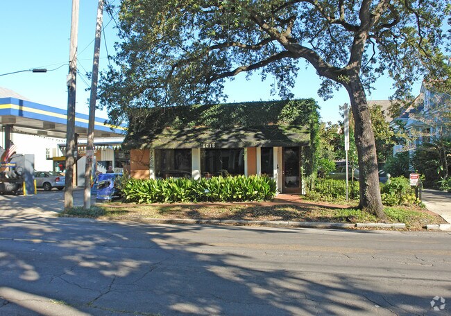
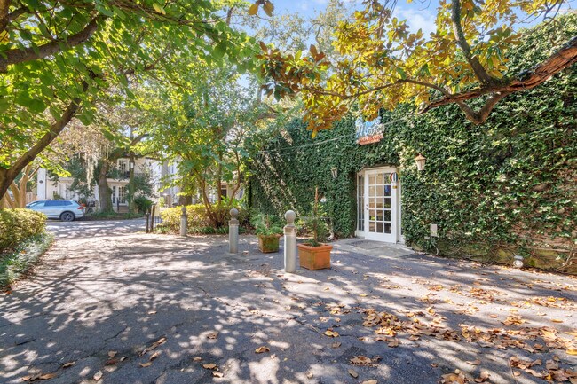
Property Record
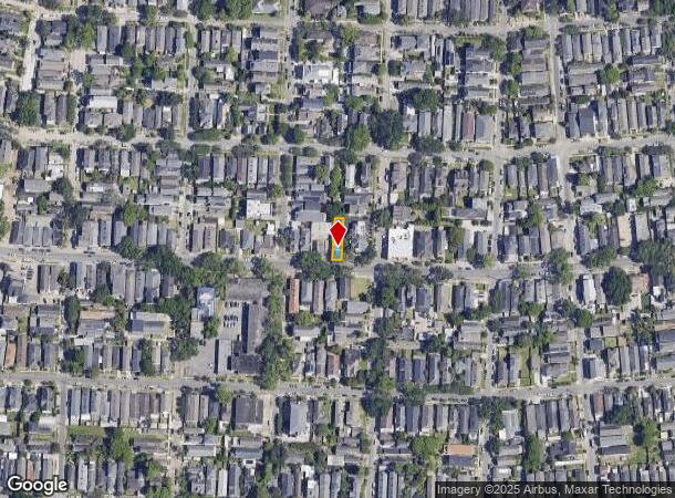
5015 Magazine St, New Orleans, LA 70115
NEARBY LISTINGS FOR SALE OR LEASE
Property Detail
5015 Magazine St
6-14-2-020-17
SQ 239 LOT 5 32 X 127 MAGAZINE CON BLOCK BLDG FILE #83728 3/02
Restaurantbuilding
Orleans
X
Louisiana
22051C0215F
5
2025
0.09 AC
2025
Uptown/Garden District
010800
New Orleans/Metairie/Kenner
1,380 SF
New Orleans-Metairie, LA
DEMOGRAPHICS near 5015 Magazine St
1 Mile
3 Mile
5 Mile
2024 Total Population
19,109
138,301
306,328
2029 Population
18,349
133,714
296,533
Pop Growth 2024-2029
(3.98%)
(3.32%)
(3.20%)
Average Age
43
40
41
2024 Total Households
9,159
60,848
136,223
HH Growth 2024-2029
(4.24%)
(3.41%)
(3.19%)
Median Household Inc
$97,203
$57,129
$52,459
Avg Household Size
2.00
2.10
2.10
2024 Avg HH Vehicles
2.00
1.00
1.00
Median Home Value
$700,000
$341,433
$278,147
Median Year Built
1946
1949
1955
Nearby Places
Map Layers
Map Styles
 Street
 Aerial
- Restaurants
- Banks
- Shops
- Fitness
- Groceries
PUBLIC TRANSPORTATION
TRANSIT/SUBWAY
St Charles and Robert (St. Charles Streetcar - New Orleans Regional Transit Authority Streetcars (New Orleans Streetcars))
DRIVE
WALK
Distance
St Charles and Robert (St. Charles Streetcar - New Orleans Regional Transit Authority Streetcars (New Orleans Streetcars))
2 min
9 min
0.5 mi
St Charles and Duffosat (St. Charles Streetcar - New Orleans Regional Transit Authority Streetcars (New Orleans Streetcars))
DRIVE
WALK
Distance
St Charles and Duffosat (St. Charles Streetcar - New Orleans Regional Transit Authority Streetcars (New Orleans Streetcars))
2 min
11 min
0.6 mi
St Charles and Bordeaux (St. Charles Streetcar - New Orleans Regional Transit Authority Streetcars (New Orleans Streetcars))
DRIVE
WALK
Distance
St Charles and Bordeaux (St. Charles Streetcar - New Orleans Regional Transit Authority Streetcars (New Orleans Streetcars))
2 min
11 min
0.6 mi
St Charles and Valmont (St. Charles Streetcar - New Orleans Regional Transit Authority Streetcars (New Orleans Streetcars))
DRIVE
WALK
Distance
St Charles and Valmont (St. Charles Streetcar - New Orleans Regional Transit Authority Streetcars (New Orleans Streetcars))
2 min
12 min
0.6 mi
St Charles and Cadiz (St. Charles Streetcar - New Orleans Regional Transit Authority Streetcars (New Orleans Streetcars))
DRIVE
WALK
Distance
St Charles and Cadiz (St. Charles Streetcar - New Orleans Regional Transit Authority Streetcars (New Orleans Streetcars))
3 min
14 min
0.7 mi
COMMUTER RAIL
DRIVE
WALK
Distance
9 min
3.6 mi
AIRPORT
Louis Armstrong New Orleans International
DRIVE
WALK
Distance
Louis Armstrong New Orleans International
28 min
17.3 mi
Freight Ports
Port of New Orleans
DRIVE
WALK
Distance
Port of New Orleans
12 min
3.7 mi
SALE & LEASE HISTORY
LISTING DATE
SALE/LEASE

Dec 30, 2024
For Lease
Nearby Properties
Address
Land Use
TOTAL SIZE
Lot Size
Zoning
Address
Land Use
TOTAL SIZE
Lot Size
Zoning
80.92 AC
EC
Address
Land Use
TOTAL SIZE
Lot Size
Zoning
66.23 AC
CBD-4
Address
Land Use
TOTAL SIZE
Lot Size
Zoning
468,704 SF
7.58 AC
MC
Address
Land Use
TOTAL SIZE
Lot Size
Zoning
3.66 AC
MC
Address
Land Use
TOTAL SIZE
Lot Size
Zoning
197,182 SF
0.01 AC
OS-R
Address
Land Use
TOTAL SIZE
Lot Size
Zoning
Address
Land Use
TOTAL SIZE
Lot Size
Zoning
609,449 SF
2 AC
EC
Address
Land Use
TOTAL SIZE
Lot Size
Zoning
10.42 AC
Address
Land Use
TOTAL SIZE
Lot Size
Zoning
0.67 AC
CBD-3
Address
Land Use
TOTAL SIZE
Lot Size
Zoning
3.36 AC
EC
Address
Land Use
TOTAL SIZE
Lot Size
Zoning
4.12 AC
Address
Land Use
TOTAL SIZE
Lot Size
Zoning
315,570 SF
4.42 AC
HU-RM2
Address
Land Use
TOTAL SIZE
Lot Size
Zoning
1.26 AC
CBD-1
Address
Land Use
TOTAL SIZE
Lot Size
Zoning
246,930 SF
9.40 AC
CBD-4
Address
Land Use
TOTAL SIZE
Lot Size
Zoning
0.08 AC
Address
Land Use
TOTAL SIZE
Lot Size
Zoning
66.97 AC
LI
Address
Land Use
TOTAL SIZE
Lot Size
Zoning
11.29 AC
HU-RD1
Address
Land Use
TOTAL SIZE
Lot Size
Zoning
559,437 SF
2.03 AC
CBD-4
Address
Land Use
TOTAL SIZE
Lot Size
Zoning
80,931 SF
6.54 AC
CBD-4
Address
Land Use
TOTAL SIZE
Lot Size
Zoning
736,350 SF
0.69 AC
CBD-1
Address
Land Use
TOTAL SIZE
Lot Size
Zoning
20.13 AC
EC
Address
Land Use
TOTAL SIZE
Lot Size
Zoning
121,349 SF
0.85 AC
CBD-3
Address
Land Use
TOTAL SIZE
Lot Size
Zoning
151,320 SF
27.55 AC
Address
Land Use
TOTAL SIZE
Lot Size
Zoning
0.30 AC
CBD-5
Address
Land Use
TOTAL SIZE
Lot Size
Zoning
Address
Land Use
TOTAL SIZE
Lot Size
Zoning
222,425 SF
1.11 AC
CBD-6
Address
Land Use
TOTAL SIZE
Lot Size
Zoning
25,744 SF
14.18 AC
LI
Address
Land Use
TOTAL SIZE
Lot Size
Zoning
0.63 AC
CBD-1
Address
Land Use
TOTAL SIZE
Lot Size
Zoning
458,640 SF
1.16 AC
CBD-4
Address
Land Use
TOTAL SIZE
Lot Size
Zoning
21.99 AC
CBD-4
The World's #1 Commercial Real Estate Marketplace
Connect with us
© 2025 CoStar Group
The information above has been obtained from sources believed reliable. While we do not doubt its accuracy we have not verified it and make no guarantee, warranty or representation about it. It is your responsibility to independently confirm its accuracy and completeness. Any projections, opinions, assumptions, or estimates used are for example only and do not represent the current or future performance of the property. The value of this transaction to you depends on tax and other factors which should be evaluated by your tax, financial, and legal advisors. You and your advisors should conduct a careful, independent investigation of the property to determine to your satisfaction the suitability of the property for your needs.